Drumheller Channels National Natural Landmark facts for kids
Quick facts for kids Drumheller Channels |
|
|---|---|

Drumheller Channels
|
|
| Lua error in Module:Location_map at line 420: attempt to index field 'wikibase' (a nil value). | |
| Location | south central Washington (state) |
| Designated | 1986 |
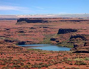
The Drumheller Channels National Natural Landmark is a special place in south central Washington state. It shows us amazing examples of what are called Channeled Scablands. These are landscapes that were carved out by huge floods long ago.
This area is full of hundreds of hills called buttes. They are surrounded by a network of channels, like a braided river. Most of these channels are dry today. The Drumheller Channels are a perfect example of how incredibly powerful the ancient Missoula Floods were. These floods reshaped the land during the last Ice Age.
In 1986, the U.S. National Park Service recognized the importance of Drumheller Channels. They named it a National Natural Landmark. A geologist named J Harlen Bretz was the first to study these floods. He described Drumheller Channels as "the most spectacular" area of its kind. He called it "an almost unbelievable labyrinth" of channels and basins.
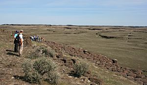
The Drumheller Channels connect the Quincy Basin in the north to the Othello Basin in the south. You can easily get there from Othello, Washington. It's about 8 kilometers (5 miles) northwest on McManamon Road. Then, turn north onto Morgan Lake Road. This road goes right through the heart of the channels and follows Crab Creek. You can take hikes there, including a special trail. This trail leads from the wetlands along Crab Creek to great views from a hill. This helps you understand how unique this landscape is. You can also see the Drumheller Channels from State Route 262. This road runs north of the area, along the top of the Potholes Reservoir dam.
Contents
How the Ancient Columbia River Changed Course
During the Ice Age, a huge sheet of ice called the Cordilleran Glacier moved south. A part of this glacier, called the Okanogan lobe, moved into the Okanogan River valley. It blocked the old path of the Columbia River. This blockage caused a large lake to form, known as Lake Spokane.
At first, water from Lake Spokane flowed out through Grand Coulee. It then went down through Foster Coulee to rejoin the Columbia River. But as the glacier moved further south, it blocked Foster Coulee. So, the Columbia River found a new path through Moses Coulee. This coulee runs south, a bit east of the river's current path.
As the Okanogan lobe grew even bigger, it blocked Moses Coulee too. The Columbia River then found the next lowest path. This path was carved out to become the modern Grand Coulee. The Ice Age Columbia River flowed through the Grand Coulee and Dry Falls areas. Then it entered the Quincy Basin and joined Crab Creek. It followed Crab Creek south past the Frenchman Hills. Finally, it turned west to flow along the north side of the Saddle Mountains. It rejoined its old and current path just before Sentinel Gap.
How the Drumheller Channels Were Formed
The powerful Missoula Floods were responsible for shaping the Drumheller Channels. These floods poured into Lake Spokane and then rushed through the Grand Coulee. This made the Grand Coulee much bigger. The water then flowed over Dry Falls and collected in the Quincy Basin. The basin was completely covered by water, forming a huge temporary lake. The floods also created a large deposit of rocks and pebbles called the Ephrata Fan.
The amount of water was so huge that it overflowed Lake Spokane in many places. Water also reached the Quincy Basin from the east through the Telford-Crab Creek scablands and Lind Coulee. When the floodwaters hit the Frenchman Hills, they were very high. Most of the water went through the Crab Creek area. But some water also spilled west over lower parts of Evergreen and Babcock ridges. This water reached the Columbia River channel at Frenchman Coulee, Potholes Coulee, and Crater Coulee. However, the main part of the floodwaters took the easiest route. This was straight south through the Drumheller Channels part of Crab Creek.
The water dropped more than 50 meters (160 feet) as it rushed through the Drumheller Channels. This happened over a distance of about 20 kilometers (12 miles). The slope of the land was very steep in some places. This steepness, combined with the water being 60 to 120 meters (200 to 400 feet) deep, gave the floods incredible power. The water could move as fast as 30 meters per second (65 mph)! This speed eroded the topsoil and the rock below. It carved out the complex network of channels, basins, potholes, and hills we see today. You can still find features like large potholes carved by swirling water, which show how powerful these floods were.
The Drumheller Channels are unique. Unlike other Channeled Scabland areas, there isn't one main channel or huge waterfalls. Instead, the floodwaters spread out in a wide cascade. This cascade was 13 to 20 kilometers (8 to 12 miles) wide. Geologist J Harlen Bretz counted 150 different channels and over 180 rock basins here. Many low areas, like Upper Goose Lake, are now filled with water. This water seeps in through cracks in the rock. It is connected to the Potholes Reservoir to the north.
Changes from Early Settlement
When people first settled in the area, there were big changes. In the 1860s, too much grazing by animals removed most of the natural grasses. Government surveys in the 1880s described much of the area as "badlands" because of this.
The Columbia Basin Project and Water
In 1934, the U.S. Bureau of Reclamation started building the Grand Coulee Dam. This dam is on the Columbia River, about 100 miles (160 km) north of the Drumheller Channels. The Grand Coulee Dam was part of a much bigger plan called the Columbia Basin Project. This project included many reservoirs, pumping stations, and thousands of miles of canals. The goal was to bring water to irrigate the region.
Irrigation began in 1951. This caused the water underground, called the water table, to rise. By 1980, when the project was finished, the amount of wetlands in the Columbia Basin had grown a lot. It was at least 20 times larger than before. This happened because of water seeping from the canals and the higher water table. Many migrating birds were attracted to the area. They found water and plenty of food from the nearby farms.
Columbia National Wildlife Refuge
The Columbia National Wildlife Refuge is located within the Drumheller Channels area. Nearby areas are also part of the Seep Lakes Wildlife Area. This region is home to more than 200 different kinds of mammals and birds. They live in the cliffs, marshes, grasslands, lakes, and other watery areas.
 | Emma Amos |
 | Edward Mitchell Bannister |
 | Larry D. Alexander |
 | Ernie Barnes |


