Dry Falls facts for kids
Quick facts for kids Dry Falls |
|
|---|---|
 |
|
| Lua error in Module:Location_map at line 420: attempt to index field 'wikibase' (a nil value). | |
| Lua error in Module:Infobox_mapframe at line 185: attempt to index field 'wikibase' (a nil value). | |
| Location | Grant County, Washington, United States |
| Type | Block |
| Elevation | 1510 feet (460 m) |
| Total height | 400 feet (121 m) |
| Total width | 3.5 miles (5.63 km) |
| Average flow rate |
None |
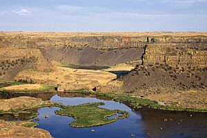
Dry Falls is a huge cliff in central Washington. It is about 3.5 miles (5.6 kilometers) long. This amazing place used to be the biggest waterfall known on Earth!
Today, Dry Falls is completely dry. But long ago, giant floods created it. These floods were so powerful they carved out the land. Imagine a waterfall five times wider than Niagara Falls! It had ten times more water than all the rivers in the world today, combined.
Contents
How Dry Falls Was Formed
About 20,000 years ago, a huge sheet of ice covered much of North America. This ice sheet was like a giant glacier. It moved south and blocked rivers.
Glacial Lakes and Ice Dams
One part of the ice sheet blocked the Clark Fork River in Idaho. This created a massive lake called Lake Missoula. At the same time, another lake formed. This was Glacial Lake Columbia. It formed when the ice blocked the Columbia River.
The Columbia River had to find a new path. It flowed through areas like Moses Coulee. As the ice dam grew, it later flowed through the Grand Coulee.
The Great Floods
Eventually, the water in Lake Missoula got so high. It lifted the ice dam. Then, the dam broke! A huge amount of water rushed out. This water poured into Glacial Lake Columbia. From there, it flowed down the Grand Coulee.
Scientists believe this happened many times. The ice dam would form, Lake Missoula would fill up, and then the dam would break. Each time, a massive flood would happen.
The Power of the Water
These floods were incredibly powerful. Water rushed through the Grand Coulee at 65 miles per hour (105 kilometers per hour). This fast-moving water carved out the huge cliff we now call Dry Falls. The floods also created deep holes at the bottom of the falls. These are called plunge pools.
Parts of Idaho, Washington, and Oregon were covered in hundreds of feet of water. This happened in just a few days! These amazing floods made the Grand Coulee and Dry Falls much bigger.
Dry Falls Today
After the last Ice Age, the giant ice sheet melted. The Columbia River went back to its original path. This left the Grand Coulee and Dry Falls completely dry.
Today, you can visit this incredible place. The Dry Falls Interpretive Center is part of Sun Lakes-Dry Falls State Park. It's located on Route 17. This is near the town of Coulee City. You can see the massive cliff from the center. There is no admission fee to enter the center. However, you need a Discover Pass to park your car.
See also
 In Spanish: Dry Falls para niños
 | Calvin Brent |
 | Walter T. Bailey |
 | Martha Cassell Thompson |
 | Alberta Jeannette Cassell |

