Grant County, Washington facts for kids
Quick facts for kids
Grant County
|
||
|---|---|---|

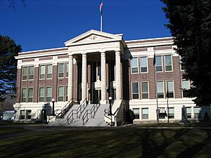
Grant County Courthouse
|
||
|
||

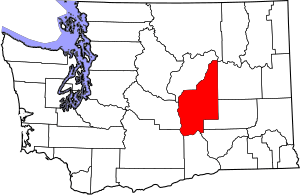
Location within the U.S. state of Washington
|
||
 Washington's location within the U.S. |
||
| Country | ||
| State | ||
| Founded | February 24, 1909 | |
| Named for | Ulysses S. Grant | |
| Seat | Ephrata | |
| Largest city | Moses Lake | |
| Area | ||
| • Total | 2,791 sq mi (7,230 km2) | |
| • Land | 2,680 sq mi (6,900 km2) | |
| • Water | 112 sq mi (290 km2) 4.0%% | |
| Population
(2020)
|
||
| • Total | 99,123 | |
| • Estimate
(2023)
|
102,678 |
|
| • Density | 35/sq mi (14/km2) | |
| Time zone | UTC−8 (Pacific) | |
| • Summer (DST) | UTC−7 (PDT) | |
| Congressional district | 4th | |
Grant County is a county in the state of Washington. In 2020, about 99,123 people lived here. The main town, called the county seat, is Ephrata. The biggest city in the county is Moses Lake.
Grant County was created in February 1909. It was named after Ulysses S. Grant, who was the 18th U.S. President. The area around Moses Lake is an important economic hub for the county.
Contents
History of Grant County
Early Settlers and Farming
Long ago, Native American groups like the Interior Salish, Wenatchi, and Okanagan lived in this area. In the mid-to-late 1800s, the first white settlers arrived. They mostly came to raise livestock like cattle.
At first, the land was seen as empty and not very promising. But when railroads came, more people moved in. The economy started to change from ranching to dryland farming. This type of farming needs a lot of water, so irrigation became very important. The first big attempts to bring water to the farms began in 1898.
Growth and the Columbia Basin Project
With more dryland farming, Grant County soon had access to three major railway lines. These were the Great Northern, Northern Pacific, and Chicago, Milwaukee & St. Paul Railroads. Also, the Columbia River nearby could be used by boats. This made it easy to transport crops out of the area. Towns like Wilson Creek, Quincy, and Ephrata began to grow and do well.
The Washington State Legislature officially created Grant County on February 24, 1909. They named it after Ulysses S. Grant, who was a hero in the American Civil War. Ephrata became the county seat. About 8,700 people lived in the county at that time.
A huge project called the Columbia Basin Project began in the 1930s. This project built the Grand Coulee Dam. The dam helped bring water for irrigation and also produced electricity. This big project changed the entire region forever.
Geography of Grant County
Grant County covers about 2,791 square miles. Most of this is land (2,680 square miles), and about 112 square miles (4%) is water. It is the fourth-largest county in Washington state.
The weather in Grant County has hot summers and cold winters. The Cascade mountains block rain from reaching eastern Washington, including Grant County. This is called a "rainshadow" effect. It makes the climate drier than western Washington.
A sign on Interstate Highway I-90 welcomes visitors to Grant County. It proudly states that the county is "The nation's leading potato producing county."
Important Geographic Features
- Columbia River
- Grand Coulee
- Moses Lake
- Potholes Reservoir
- Soap Lake
- Ulysses S. Peak (a high point in the county)
Major Roads
Neighboring Counties
- Douglas County - to the north
- Okanogan County - to the northeast
- Adams County - to the east
- Lincoln County - to the east
- Franklin County - to the southeast
- Benton County - to the south
- Yakima County - to the southwest
- Kittitas County - to the west
Protected Natural Areas
- Columbia National Wildlife Refuge (part)
- Hanford Reach National Monument (part)
- Lake Roosevelt National Recreation Area (part)
- Saddle Mountain National Wildlife Refuge (part)
People of Grant County
| Historical population | |||
|---|---|---|---|
| Census | Pop. | %± | |
| 1910 | 8,698 | — | |
| 1920 | 7,771 | −10.7% | |
| 1930 | 5,666 | −27.1% | |
| 1940 | 14,668 | 158.9% | |
| 1950 | 24,346 | 66.0% | |
| 1960 | 46,477 | 90.9% | |
| 1970 | 41,881 | −9.9% | |
| 1980 | 48,522 | 15.9% | |
| 1990 | 54,758 | 12.9% | |
| 2000 | 74,698 | 36.4% | |
| 2010 | 89,120 | 19.3% | |
| 2020 | 99,123 | 11.2% | |
| 2023 (est.) | 102,678 | 15.2% | |
| U.S. Decennial Census 1790–1960 1900–1990 1990–2000 2010–2020 |
|||
Population in 2020
In 2020, Grant County had 99,123 people living in 32,803 homes. The county had about 37 people per square mile. Most people (90.8%) were White. About 43.6% of the population was of Hispanic or Latino background.
About 28.3% of the people were under 18 years old. About 7.1% were under 5 years old. People over 65 made up 14.7% of the population. The number of males and females was almost equal. About 48.9% were female and 51.1% were male.
The average income for a household was $63,566 per year. The income per person was $27,466. About 11.7% of the people lived below the poverty line.
Population in 2010
In 2010, there were 89,120 people in Grant County. There were 30,041 households. About 40.6% of homes had children under 18. Most homes (54.7%) were married couples.
The average age of people in the county was 32.1 years. The average household had 2.93 people. The average family had 3.40 people.
The average income for a household was $42,572. For families, it was $50,065. About 20.4% of the population lived below the poverty line. This included 28.4% of those under 18.
Communities in Grant County
Cities
- Electric City
- Ephrata (the county seat)
- George
- Grand Coulee
- Mattawa
- Moses Lake
- Quincy
- Royal City
- Soap Lake
- Warden
Towns
- Coulee City
- Coulee Dam (partly in Grant County)
- Hartline
- Krupp (also known as Marlin)
- Wilson Creek
Census-Designated Places
These are areas that are not officially cities or towns, but are recognized for census purposes.
- Banks Lake South
- Beverly
- Cascade Valley
- Crescent Bar
- Desert Aire
- Lakeview
- Marine View
- Moses Lake North
- Schwana
- Sunland Estates
- Wheeler
Other Small Communities
These are other small places that are not officially incorporated.
Education in Grant County
There are many school districts in Grant County. They help educate the children and teens living there.
- Almira School District
- Coulee-Hartline School District
- Ephrata School District
- Grand Coulee Dam School District
- Moses Lake School District
- Odessa School District
- Othello School District
- Quincy School District
- Royal School District
- Soap Lake School District
- Wahluke School District
- Warden School District
- Wilson Creek School District
Economy of Grant County
Grant County is very important for farming. It is the number one crop-producing county in Washington State. A large amount of the state's hay harvest comes from Grant County.
See also
 In Spanish: Condado de Grant (Washington) para niños
 | John T. Biggers |
 | Thomas Blackshear |
 | Mark Bradford |
 | Beverly Buchanan |


