Beverly, Washington facts for kids
Quick facts for kids
Beverly, Washington
|
|
|---|---|

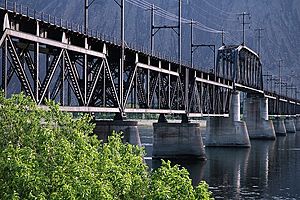
Beverly Railroad Bridge over the Columbia River at Beverly
|
|
| Country | United States |
| State | Washington |
| County | Grant |
| Elevation | 550 ft (170 m) |
| Time zone | UTC-8 (Pacific (PST)) |
| • Summer (DST) | UTC-7 (PDT) |
| ZIP code |
99321
|
| Area code(s) | 509 |
| GNIS feature ID | 2807177 |
Beverly, Washington is a small town in the United States. It's located right next to the Columbia River in central Washington state. Beverly is an unincorporated community, meaning it doesn't have its own city government.
Only a few hundred people live here. In 2020, the population was 266. Beverly is a short distance downstream from the Wanapum Dam. It sits at the bottom of Sentinel Gap, which is a natural opening in the Saddle Mountains. This gap was there long before the Columbia River.
Contents
The Story of Beverly: A Look Back
How Beverly Got Its Name
Beverly was named around 1905. A person named H.R. Williams chose the name. He named it after a town called Beverly, Massachusetts.
Railroad Days in Beverly
From 1905 to the 1920s, Beverly was a busy place. Hundreds of workers lived there. They were building the Milwaukee Railroad. This railroad was a big project.
Building the Big Bridge
The Milwaukee Railroad built a huge bridge near Beverly. It crossed the Columbia River. This bridge cost a million dollars, which was a lot of money back then! It was finished in 1909. Supplies for the bridge came by steamboat and other train lines. The bridge took almost two years to build.
Why Beverly Was Important for Trains
Beverly's early success was partly because of the railroad's steep hills. Trains needed extra locomotives, called "helper locomotives," to get up these hills. Companies even printed colorful brochures. They told people back east about Beverly's good weather. They also talked about its long growing season and safe location.
Changes for the Railroad and Beverly
In 1977, the Milwaukee Road company went bankrupt. In the early 1980s, Washington State removed the train tracks. They took them from east of Beverly to a place near Royal City. But the old black iron bridge, which is over 100 years old, still stands today. It still crosses the river.
Beverly's Role in World War II
During World War II and up to the 1980s, many train cars passed through Beverly. They were going to the nearby Hanford facility. Hanford was a very important site for the war effort. The train station in Beverly was updated during this time. It was made better and bigger. The station is no longer there. It was torn down sometime between the late 1990s and early 2000s.
Beverly Today: Life in the Community
Beverly's Post Office
Beverly is still an unincorporated community. But it does have its own ZIP code. The old post office building burned down in 2003. This was due to arson, which means someone purposely set it on fire. It was the only post office arson in Washington State in 50 years.
Today, Beverly has a temporary post office. This building was made to help communities during emergencies. For example, it could be used during forest fires. This mobile building has been serving the 99321 ZIP code for the last six years.
Keeping the Post Office
People who live in Beverly want to keep their post office. But residents in the nearby town of Mattawa have a different idea. They have suggested that Beverly's post office combine with Mattawa's.
Beverly's Weather
Understanding Beverly's Climate
Beverly has a semi-arid climate. This means it's usually dry. On climate maps, this type of weather is shown as "BSk." This is based on the Köppen Climate Classification system.
See also
 In Spanish: Beverly (Washington) para niños
 | Janet Taylor Pickett |
 | Synthia Saint James |
 | Howardena Pindell |
 | Faith Ringgold |


