
Wanapum Dam facts for kids
Quick facts for kids Wanapum Dam |
|
|---|---|

Dam viewed from downstream on the west bank
|
|
| Official name | Wanapum Dam |
| Location | Grant / Kittitas counties, Washington |
| Coordinates | 46°52′31″N 119°58′16″W / 46.875213°N 119.971004°W |
| Construction began | 1959 |
| Opening date | 1963 |
| Construction cost | US$93,277,690 |
| Dam and spillways | |
| Impounds | Columbia River |
| Height | 185 feet (56 m) |
| Length | 8,320 feet (2,540 m) |
| Reservoir | |
| Creates | Lake Wanapum |
| Total capacity | 796,000 acre-feet (982,000,000 m3) |
| Power station | |
| Commission date | 1963 |
| Turbines | 10 x 104 MW Kaplan-type |
| Installed capacity | 1,185 megawatts (1,589,000 hp) |

The Wanapum Dam is a large hydroelectric project. It is built on the Columbia River in Washington state. The dam is located south of Vantage, Washington. This is where Interstate 90 crosses the Columbia River.
The dam and its lake, Lake Wanapum, are named after the Wanapum Native American people. The dam can produce 1,185 megawatts of power. It generates over 4 million megawatt-hours of electricity each year. This is enough to power many homes and businesses. The Grant County Public Utility District owns and operates the dam.
Contents
Building the Wanapum Dam
The Wanapum Dam was first approved in 1955. Its construction began in 1959. The dam started working and producing power in 1963. The first approval for the dam lasted for 50 years.
Keeping the Dam Running
After 50 years, the dam needed a new approval to keep operating. This new approval was given on April 17, 2008. It allows the Wanapum Dam and the nearby Priest Rapids Dam to operate for another 44 years.
This new approval came with important goals:
- Make the dam's power generation better and more modern.
- Check the water quality to keep it clean.
- Improve places where wildlife lives.
- Protect nearly 700 important cultural sites of the Wanapum Tribe.
- Add new campsites, picnic areas, and trails for people to enjoy.
What Happened with the Spillway Crack?
On February 27, 2014, something unexpected happened. Divers inspecting the dam found a crack. It was about 2-inch (5 cm) wide. The crack was on one of the large concrete sections of the spillway. These sections are about 65 feet (20 m) tall.
To fix this, the water level behind the dam was lowered. It went down by 26 feet (8 m) over several days. This helped reduce pressure on the crack. During the repairs, all beaches and water access above the dam were closed. This was to protect important cultural sites and keep people safe. Public access returned in the spring of 2015.
After a long inspection, engineers found the main reason for the crack. It was due to a math error made when the dam was first designed. Repairs were made in 2014 and 2015. The fix cost $61 million. It involved using steel cables and rods to connect the dam to the bedrock below. This made the dam strong and safe again.
Images for kids
-
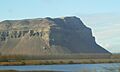
Basalt bluff over the Columbia River near Wanapum Dam
-
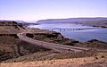
Vantage Bridge crossing Wanapum Lake


