Saddle Mountains facts for kids
Quick facts for kids Saddle Mountains |
|
|---|---|

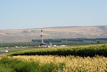
The Saddle Mountains as seen from the south in the summer of 2006. Note gas drilling rig in the foreground.
|
|
| Highest point | |
| Peak | Wahatis Peak |
| Elevation | 2,634 ft (803 m) |
| Geography | |
| Country | United States |
| State | Washington |
| County | Grant County |
| Range coordinates | 46°48′24″N 119°33′28″W / 46.80667°N 119.55778°W |
The Saddle Mountains are a long, low mountain range in central Washington state. They are mostly made of a type of volcanic rock called basalt. This rock formed from ancient lava flows.
The mountains reach about 2,700 feet (823 meters) high. To the east, they end near Othello, Washington, close to the Drumheller Channels National Natural Landmark. To the west, the mountains are split by a narrow pass called Sentinel Gap. The Columbia River flows right through this gap. The range then continues into the foothills of the Cascade Mountains.
How the Saddle Mountains Formed
The Saddle Mountains are like a giant wrinkle in the Earth's surface. Geologists call this a "folded ridge" or anticline. It formed when layers of volcanic rock, called Columbia River Basalt, were pushed up.
The top layers of rock you can see are part of the Saddle Mountain Basalt. These layers are very thick, from 400 to 800 feet (120 to 240 meters). Between these hard basalt layers, there are softer layers of dirt and ancient sediments. These layers tell us about the different lava flows that happened millions of years ago. For example, some flows like the Asotin Member happened about 13 million years ago, and the Elephant Mountain Member about 10.5 million years ago.
How Ice Shaped the Mountains
About 15,000 years ago, during the last Ice Age, a huge sheet of ice called the Cordilleran Glacier covered much of North America. This ice sheet was so big it changed the path of the Columbia River.
The ice blocked the river, creating a large lake called Lake Spokane. As the ice grew, the Columbia River was forced to flow in a new direction. It carved out a huge channel called the Grand Coulee. The river then flowed into the Quincy Basin near Quincy, Washington. It joined Crab Creek near Moses Lake.
The river then turned west and flowed along the northern side of the Saddle Mountains. This powerful flow of water eroded, or wore away, the northern face of the mountains. This erosion helped create features like the Corfu Slide. Eventually, the river rejoined its old path just before Sentinel Gap, where it flows today.
Exploring Saddle Mountains Geography
The Saddle Mountains stretch across Grant County. Here are some key spots along the range:
- The eastern part of the mountains is where Lower Crab Creek meets the area known as the Corfu Slide.
- The Red Rock Coulee area is another interesting spot within the mountains.
- Sentinel Gap is a famous landmark. It's the narrow opening where the mighty Columbia River cuts right through the mountains.
 | Roy Wilkins |
 | John Lewis |
 | Linda Carol Brown |


