Okanogan County, Washington facts for kids
Quick facts for kids
Okanogan County
|
||
|---|---|---|

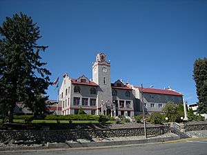
Okanogan County Courthouse in Okanogan
|
||
|
||

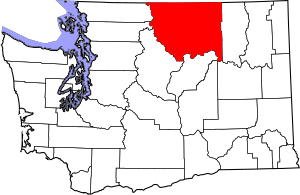
Location within the U.S. state of Washington
|
||
 Washington's location within the U.S. |
||
| Country | ||
| State | ||
| Founded | February 2, 1888 | |
| Named for | Fort Okanogan | |
| Seat | Okanogan | |
| Largest city | Omak | |
| Area | ||
| • Total | 5,312.7 sq mi (13,760 km2) | |
| • Land | 5,266.2 sq mi (13,639 km2) | |
| • Water | 46.5 sq mi (120 km2) 0.9%% | |
| Population
(2020)
|
||
| • Total | 42,104 | |
| • Estimate
(2023)
|
43,712 |
|
| • Density | 8.3/sq mi (3.2/km2) | |
| Time zone | UTC−8 (Pacific) | |
| • Summer (DST) | UTC−7 (PDT) | |
| Congressional district | 4th | |
Okanogan County is a county in the state of Washington. It is located right next to the border with Canada. In 2020, about 42,104 people lived there.
The main town, or county seat, is Okanogan. The biggest city in the county is Omak. Okanogan County is the largest county in Washington state by land area.
A large part of the county's people live in the Omak area. The county is also part of a bigger region called Okanogan Country. The very first county seat was a place called Ruby. Today, Ruby is a ghost town, meaning no one lives there anymore.
Okanogan County was created in February 1888. It was formed from parts of Stevens County. The name "Okanogan" comes from the ukʷnaqín language, spoken by the Okanagan people. The name Okanogan also refers to a part of southern British Columbia in Canada.
Contents
History of Okanogan County
Before Europeans arrived, many indigenous peoples lived in the Okanogan County area. These groups included the Northern Okanogans (also called Sinkaietk), Tokoratums, Kartars, and Konkonelps. They spoke different types of Interior Salish languages.
The Okanogan people enjoyed a good climate. They would camp in different places depending on the season. In winter, they stayed in camps. In spring, they hunted bears. During summer, they caught fish, and in fall, they hunted deer. Their homes were like teepees, made from animal hides and tree bark. Women gathered nuts and berries for food. A popular spot for fishing was Kettle Falls, where the Columbia River dropped about 20 feet.
Okanogan County was one of the last areas in Washington to be settled by Europeans. This was because it was very far away from other towns. Early on, it was a path for prospectors looking for gold and other valuable minerals. They used the area to reach places like British Columbia.
By the 21st century, the county became known for farming, logging (forestry), and tourism. A large electric power plant, the Grand Coulee Dam, was built nearby. It was constructed between 1933 and 1942. The dam is located where Okanogan and Grant counties meet.
In July 2014, a very large wildfire called the Carlton Complex fire happened in Okanogan County. It burned over 250,000 acres (about 390 square miles) of land. The fire destroyed more than 300 homes, including 100 homes in and around Pateros.
Geography of Okanogan County

Okanogan County covers a total area of about 5,312.7 square miles. Most of this is land (5,266.2 square miles), and a small part is water (46.5 square miles). It is the largest county in Washington state. In fact, it is bigger than three entire U.S. states!
Important Geographic Features
- Cascade Mountains
- Columbia River
- Okanogan River
- North Gardner Mountain (the highest point in the county)
- Beaner Lake
Main Roads in Okanogan County
Neighboring Counties and Districts
- Fraser Valley Regional District, British Columbia (northwest)
- Okanagan-Similkameen Regional District, British Columbia (north)
- Kootenay Boundary Regional District, British Columbia (northeast)
- Ferry County (east)
- Lincoln County (southeast)
- Grant County (south)
- Douglas County (south)
- Chelan County (southwest)
- Skagit County (west)
- Whatcom County (west)
Protected Natural Areas
- Pacific Northwest National Scenic Trail (part of it)
- Nez Perce National Historical Park (part of it)
- Okanogan–Wenatchee National Forest
- Pasayten Wilderness
Population of Okanogan County
| Historical population | |||
|---|---|---|---|
| Census | Pop. | %± | |
| 1890 | 1,467 | — | |
| 1900 | 4,689 | 219.6% | |
| 1910 | 12,887 | 174.8% | |
| 1920 | 17,094 | 32.6% | |
| 1930 | 18,519 | 8.3% | |
| 1940 | 24,546 | 32.5% | |
| 1950 | 29,131 | 18.7% | |
| 1960 | 25,520 | −12.4% | |
| 1970 | 25,867 | 1.4% | |
| 1980 | 30,639 | 18.4% | |
| 1990 | 33,350 | 8.8% | |
| 2000 | 39,564 | 18.6% | |
| 2010 | 41,120 | 3.9% | |
| 2020 | 42,104 | 2.4% | |
| 2023 (est.) | 43,712 | 6.3% | |
| U.S. Decennial Census 1790–1960 1900–1990 1990–2000 2010–2020 |
|||
Population in 2020
In 2020, the county had 42,104 people living there. There were about 16,942 households. The population density was about 8 people per square mile.
Most of the people in the county were White (65.6%). About 11.6% were Native American. People of Hispanic or Latino origin made up 19.5% of the population.
About 21.7% of the people were under 18 years old. Also, 23.8% of the people were 65 years old or older.
Population in 2010
In 2010, there were 41,120 people living in Okanogan County. The population density was about 7.8 people per square mile.
About 73.9% of the people were white. About 11.4% were American Indian. People of Hispanic or Latino origin made up 17.6% of the population.
The average age of people in the county was 42.9 years old.
Towns and Cities in Okanogan County

Cities
Towns
- Conconully
- Coulee Dam (part of this town is in Okanogan County)
- Elmer City
- Nespelem
- Riverside
- Twisp
- Winthrop
Census-Designated Places (CDPs)
These are areas that are like towns but are not officially incorporated as cities or towns.
Other Small Communities
Ghost Towns
These are places where people used to live, but now no one does.
See also
 In Spanish: Condado de Okanogan para niños
 | John T. Biggers |
 | Thomas Blackshear |
 | Mark Bradford |
 | Beverly Buchanan |


