Okanogan, Washington facts for kids
Quick facts for kids
Okanogan
|
||
|---|---|---|
| City of Okanogan | ||

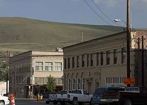
Skyline of downtown Okanogan
|
||
|
||
| Motto(s):
100 Years of Community Pride
|
||

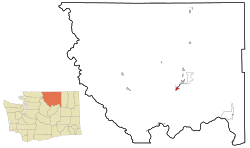
Location of Okanogan in
Okanogan County, Washington |
||
| Country | United States | |
| State | Washington | |
| County | Okanogan | |
| Established | 1888 | |
| Incorporated | October 29, 1907 | |
| Government | ||
| • Type | Mayor–council | |
| Area | ||
| • City | 2.12 sq mi (5.48 km2) | |
| • Land | 2.01 sq mi (5.20 km2) | |
| • Water | 0.11 sq mi (0.28 km2) | |
| • Urban | 4.736 sq mi (12.267 km2) | |
| Elevation | 840 ft (256 m) | |
| Population
(2020)
|
||
| • City | 2,379 | |
| • Density | 1,122.2/sq mi (434.1/km2) | |
| Time zone | UTC-8 (PST) | |
| • Summer (DST) | UTC-7 (PDT) | |
| ZIP code |
98840
|
|
| Area code(s) | 509 | |
| FIPS code | 53-50920 | |
| GNIS feature ID | 1531489 | |
Okanogan is a city in Okanogan County, Washington, United States. The name "Okanogan" comes from the Syilx'tsn word for "rendezvous" or "meeting place."
In 2020, about 2,379 people lived here. This city is also the main town for Okanogan County. It has a small airport called Okanogan Legion Airport for smaller planes.
Contents
History of Okanogan City
Okanogan became an official city on October 29, 1907. This means it got its own local government.
In 2022, something cool was found during a building renovation. Two very old murals, about 115 years old and 60 feet long, were discovered. They were hidden inside a building that used to be a theater.
People first thought a famous photographer, Frank S. Matsura, might have painted them. He used to play music on stage in that very building. Later, the Okanogan County Historical Society found an old newspaper from 1915. It said that a local artist from Wenatchee, W.J. McConnon, had painted them.
The building owners plan to carefully remove and fix these murals. After they are restored, they will be shown as a special part of a historical exhibit.
Geography and Location
Okanogan is located in Washington state, near the Okanogan River. The city covers about 2 square miles (5.2 square kilometers). Most of this area is land, with a small part being water.
Climate in Okanogan
Okanogan has a semi-arid climate. This means it's usually dry, but not a desert. It gets some rain, but not a lot. The weather station that records the climate for Okanogan is in a nearby town called Omak.
| Climate data for Omak (1909–2013) | |||||||||||||
|---|---|---|---|---|---|---|---|---|---|---|---|---|---|
| Month | Jan | Feb | Mar | Apr | May | Jun | Jul | Aug | Sep | Oct | Nov | Dec | Year |
| Record high °F (°C) | 60 (16) |
63 (17) |
79 (26) |
96 (36) |
101 (38) |
117 (47) |
114 (46) |
107 (42) |
102 (39) |
90 (32) |
77 (25) |
67 (19) |
117 (47) |
| Mean daily maximum °F (°C) | 30.2 (−1.0) |
38.3 (3.5) |
51.9 (11.1) |
64.1 (17.8) |
73.5 (23.1) |
80.6 (27.0) |
88.8 (31.6) |
87.1 (30.6) |
77.1 (25.1) |
62.2 (16.8) |
43.6 (6.4) |
33.0 (0.6) |
60.9 (16.1) |
| Daily mean °F (°C) | 23.4 (−4.8) |
29.9 (−1.2) |
40.4 (4.7) |
50.1 (10.1) |
58.4 (14.7) |
65.4 (18.6) |
72.2 (22.3) |
70.5 (21.4) |
61.2 (16.2) |
48.8 (9.3) |
35.5 (1.9) |
26.9 (−2.8) |
48.6 (9.2) |
| Mean daily minimum °F (°C) | 16.6 (−8.6) |
21.5 (−5.8) |
29.0 (−1.7) |
36.1 (2.3) |
43.3 (6.3) |
50.2 (10.1) |
55.6 (13.1) |
53.9 (12.2) |
45.3 (7.4) |
35.5 (1.9) |
27.5 (−2.5) |
20.8 (−6.2) |
36.3 (2.4) |
| Record low °F (°C) | −22 (−30) |
−26 (−32) |
−7 (−22) |
15 (−9) |
19 (−7) |
30 (−1) |
35 (2) |
31 (−1) |
20 (−7) |
8 (−13) |
−6 (−21) |
−21 (−29) |
−26 (−32) |
| Average precipitation inches (mm) | 1.32 (34) |
1.08 (27) |
0.83 (21) |
0.87 (22) |
0.98 (25) |
1.13 (29) |
0.61 (15) |
0.49 (12) |
0.56 (14) |
0.89 (23) |
1.44 (37) |
1.66 (42) |
11.86 (301) |
| Average snowfall inches (cm) | 7.3 (19) |
4.0 (10) |
0.7 (1.8) |
0 (0) |
0 (0) |
0 (0) |
0 (0) |
0 (0) |
0 (0) |
0 (0) |
2.5 (6.4) |
7.7 (20) |
22.3 (57) |
| Average precipitation days (≥ 0.01 in) | 8 | 6 | 5 | 5 | 5 | 6 | 3 | 3 | 4 | 5 | 8 | 9 | 68 |
| Source: Western Regional Climate Center, The Weather Channel | |||||||||||||
Population of Okanogan
| Historical population | |||
|---|---|---|---|
| Census | Pop. | %± | |
| 1910 | 611 | — | |
| 1920 | 1,015 | 66.1% | |
| 1930 | 1,519 | 49.7% | |
| 1940 | 1,735 | 14.2% | |
| 1950 | 2,013 | 16.0% | |
| 1960 | 2,001 | −0.6% | |
| 1970 | 2,015 | 0.7% | |
| 1980 | 2,326 | 15.4% | |
| 1990 | 2,370 | 1.9% | |
| 2000 | 2,484 | 4.8% | |
| 2010 | 2,552 | 2.7% | |
| 2020 | 2,379 | −6.8% | |
| U.S. Decennial Census 2020 Census |
|||
The population of Okanogan has changed over the years. In 2010, there were 2,552 people living in the city. By 2020, the population was 2,379.
Most people living in Okanogan are White. There are also groups of Native American, African American, and Asian residents. About 14% of the population is Hispanic or Latino.
The average age in Okanogan is about 37.7 years old. Many families live here, with about one-third of households having children under 18.
Sister City Connection
Okanogan has a special connection with another city, called a Sister City. This helps build friendships and understanding between different places.
See also
 In Spanish: Okanogan (Washington) para niños
 | Victor J. Glover |
 | Yvonne Cagle |
 | Jeanette Epps |
 | Bernard A. Harris Jr. |


