Keremeos facts for kids
Quick facts for kids
Keremeos
K Town
|
|
|---|---|
|
Village
|
|
| The Corporation of the Village of Keremeos | |

Village of Keremeos
|
|
| Motto(s):
Healthy Living, Naturally
|
|
| Country | Canada |
| Province | British Columbia |
| Region | Similkameen Country |
| Regional district | Okanagan-Similkameen |
| Incorporated | 1956 |
| Founded | 1909 |
| Area | |
| • Total | 2.09 km2 (0.81 sq mi) |
| Elevation | 365 m (1,198 ft) |
| Population
(2016)
|
|
| • Total | 1,502 |
| • Density | 717.5/km2 (1,858/sq mi) |
| Time zone | UTC-8 (PST) |
| Postal code |
V0X 1N0
|
| Area code(s) | 250 / 778 / 236 |
| Highways | |
| Waterways | Similkameen River |
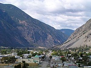
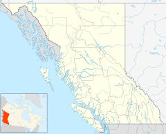
Keremeos is a small village located in the southern part of British Columbia, Canada. It's a place known for its beautiful natural surroundings. The name "Keremeos" comes from an old local language called Okanagan. It means "creek which cuts its way through the flats," describing Keremeos Creek that flows into the Similkameen River near the village.
Contents
History of Keremeos
Keremeos has a history that feels a bit like the "Wild West." It started to grow in 1909. A man named George Kirby bought land by the Similkameen River. He expected a railway, the V.V. & E. Railway, to pass through the area.
Soon after, the Great Northern Railway built a line from the US up to Hedley. This brought more businesses to the area. Keremeos officially became a village in 1956.
Geography and Landscape
The area around Keremeos has many different types of landscapes. Along the river, you can find cottonwood trees. There are also many fruit orchards and farms.
As you move away from the river, the land becomes more like a desert. This is especially true near the mountains. Higher up, you'll find alpine peaks and flat areas called plateaux.
Population and Demographics
In 2021, a count of the population called a census showed that 1,608 people lived in Keremeos. This was a small increase from 1,502 people in 2016. The village covers an area of about 2.09 square kilometers.
Economy and Industries
Keremeos has several important industries. These include growing fruits and vegetables (called horticulture and agriculture), ranching, and wine making.
The village is also famous for its many fruit stands. This is why it's known as the "fruit stand capital of Canada." Many different kinds of soft fruits, like apples, cherries, and peaches, grow here. Vegetables also thrive in the warm, dry climate of the South Similkameen valley. More and more vineyards and wineries are opening as the area becomes known for its wine.
Local Attractions
One popular place to visit in Keremeos is the Keremeos Grist Mill. It's an old mill that shows how things were done in the past.
Climate in Keremeos
Keremeos has a semi-arid climate. This means it has cool, short winters and hot, dry summers. It doesn't get a lot of rain or snow, with about 323 millimeters of precipitation each year. This precipitation is spread out fairly evenly throughout the year.
| Climate data for Keremeos | |||||||||||||
|---|---|---|---|---|---|---|---|---|---|---|---|---|---|
| Month | Jan | Feb | Mar | Apr | May | Jun | Jul | Aug | Sep | Oct | Nov | Dec | Year |
| Record high °C (°F) | 13.0 (55.4) |
16.5 (61.7) |
26.0 (78.8) |
31.0 (87.8) |
36.5 (97.7) |
38.0 (100.4) |
39.5 (103.1) |
37.5 (99.5) |
36.0 (96.8) |
28.5 (83.3) |
18.0 (64.4) |
13.0 (55.4) |
39.5 (103.1) |
| Mean daily maximum °C (°F) | 1.1 (34.0) |
5.3 (41.5) |
12.0 (53.6) |
17.0 (62.6) |
21.2 (70.2) |
24.8 (76.6) |
28.2 (82.8) |
28.6 (83.5) |
23.7 (74.7) |
15.2 (59.4) |
6.1 (43.0) |
0.2 (32.4) |
15.3 (59.5) |
| Daily mean °C (°F) | −2.0 (28.4) |
1.0 (33.8) |
6.1 (43.0) |
10.3 (50.5) |
14.4 (57.9) |
18.0 (64.4) |
20.9 (69.6) |
20.9 (69.6) |
16.2 (61.2) |
9.3 (48.7) |
2.5 (36.5) |
−2.8 (27.0) |
9.6 (49.3) |
| Mean daily minimum °C (°F) | −5.1 (22.8) |
−3.4 (25.9) |
0.2 (32.4) |
3.5 (38.3) |
7.5 (45.5) |
11.1 (52.0) |
13.5 (56.3) |
13.1 (55.6) |
8.6 (47.5) |
3.4 (38.1) |
−1.2 (29.8) |
−5.7 (21.7) |
3.8 (38.8) |
| Record low °C (°F) | −25.0 (−13.0) |
−22.0 (−7.6) |
−14.5 (5.9) |
−4.5 (23.9) |
−2.0 (28.4) |
2.0 (35.6) |
5.0 (41.0) |
4.0 (39.2) |
−2.5 (27.5) |
−14.0 (6.8) |
−24.5 (−12.1) |
−26.0 (−14.8) |
−26.0 (−14.8) |
| Average precipitation mm (inches) | 31.8 (1.25) |
22.8 (0.90) |
19.5 (0.77) |
21.8 (0.86) |
33.8 (1.33) |
39.5 (1.56) |
29.7 (1.17) |
24.8 (0.98) |
14.6 (0.57) |
19.0 (0.75) |
31.8 (1.25) |
36.5 (1.44) |
325.4 (12.81) |
| Average rainfall mm (inches) | 10.5 (0.41) |
13.0 (0.51) |
18.2 (0.72) |
21.8 (0.86) |
33.8 (1.33) |
39.5 (1.56) |
29.7 (1.17) |
24.8 (0.98) |
14.6 (0.57) |
18.6 (0.73) |
22.5 (0.89) |
9.6 (0.38) |
256.6 (10.10) |
| Average snowfall cm (inches) | 21.3 (8.4) |
9.8 (3.9) |
1.3 (0.5) |
0.0 (0.0) |
0.0 (0.0) |
0.0 (0.0) |
0.0 (0.0) |
0.0 (0.0) |
0.0 (0.0) |
0.3 (0.1) |
9.3 (3.7) |
26.9 (10.6) |
68.9 (27.1) |
| Average precipitation days (≥ 0.2 mm) | 9.3 | 8.5 | 8.8 | 8.6 | 10.3 | 10.5 | 8.3 | 7.3 | 5.7 | 7.7 | 11.1 | 10.8 | 106.7 |
| Average rainy days (≥ 0.2 mm) | 4.5 | 6.2 | 8.3 | 8.6 | 10.3 | 10.5 | 8.3 | 7.3 | 5.7 | 7.6 | 9.2 | 3.9 | 90.4 |
| Average snowy days (≥ 0.2 cm) | 5.2 | 2.5 | 0.9 | 0.0 | 0.0 | 0.0 | 0.0 | 0.0 | 0.0 | 0.2 | 2.6 | 7.6 | 18.9 |
| Source: Environment Canada | |||||||||||||
Transportation and Infrastructure
Keremeos has public transportation services. Route 50 of the South Okanagan-Similkameen Transit System runs three times a week all year. These buses connect Keremeos to places like Coalmont in the west and Penticton in the east. From Penticton, you can connect to other BC Transit buses that go to Kelowna and Osoyoos.
After Greyhound stopped its bus services in 2019, this public transit is the main way for residents to travel between cities. The closest airport with regular flights is the Penticton Regional Airport, about 41 kilometers north. For international flights, the nearest major airport is Kelowna International Airport. Keremeos used to have a train station, but the train tracks are no longer in the Similkameen Valley.
Education in Keremeos
Students in the Keremeos area attend several schools. These include Cawston primary school and Similkameen Elementary Secondary School right in the area. Other nearby schools are Penticton Secondary School, Princess Margaret Secondary School, Osoyoos, and Princeton.
 | May Edward Chinn |
 | Rebecca Cole |
 | Alexa Canady |
 | Dorothy Lavinia Brown |


