Similkameen River facts for kids
Quick facts for kids Similkameen River |
|
|---|---|

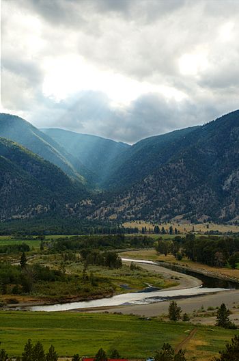
The Similkameen River near Keremeos
|
|
| Country | Canada, United States |
| State | Washington |
| Province | British Columbia |
| Physical characteristics | |
| Length | 197 km (122 mi) |
| Basin features | |
| Basin size | 7,600 km2 (2,900 sq mi) |
The Similkameen River flows through southern British Columbia, Canada. It eventually joins the Okanagan River near Oroville, Washington, in the United States. The river's name comes from an Indigenous group called Similkameigh. This name means "treacherous waters."
The river has a dam called the Enloe Dam. This dam stops fish from swimming upstream into the Canadian parts of the river.
Contents
History of the Similkameen River
The Similkameen River was first written about by a European explorer named Alexander Ross. He was a fur trader who traveled along the "Similkameigh River."
Later, Sir George Simpson used the name Similkameigh for one of the groups in the Okanagan Nation. The name changed from Similkameigh to Similkameen possibly because it sounded like the Tulameen River. The original name Similkameigh comes from an old language called Nicola-Similkameen. It is thought to mean "Salmon river."
Geography of the Similkameen River
Where the Similkameen River Flows
The Similkameen River starts at Nordheim Peak. This peak is on the east side of Manning Park. It's about 10.3 km (6.4 mi) north of Allison Pass.
The river flows past several towns. These include East Gate, Princeton, Hedley, Keremeos, and Cawston. Highway 3, also known as the Crowsnest Highway, follows the river closely.
About 25 km (16 mi) upstream from Princeton, the river goes over Similkameen Falls. You can see great views of the river from the highway. A popular spot is Bromley Rock. Here, you can swim in the river from a sandy beach. In the summer, the water is warm and perfect for swimming.
The Similkameen River provides 75% of the water flow for the Okanogan River. It crosses the border into the United States at Nighthawk, Washington.
How Much Water Flows in the Similkameen River
The United States Geological Survey measures the river's flow. They have a special station about 15.8 mi (25.4 km) upstream from the Oroville–Tonasket Irrigation District canal.
On average, the river's flow is about 2,283 cubic feet per second (64.6 m3/s). The highest flow ever recorded was 45,800 cu ft/s (1,300 m3/s). The lowest flow was 65 cu ft/s (1.8 m3/s).
The Enloe Dam and Fish Passage
The Enloe Dam was finished in 1920. It is located just before the Similkameen River joins another river. After flowing over the dam, the river drops over what remains of Coyote Falls.
The Enloe Dam does not have "fish ladders." Fish ladders are special steps that help fish swim past dams. Because there are no fish ladders, the dam completely blocks fish like salmon from swimming upstream. This means these fish cannot reach the upper parts of the Similkameen River in Canada.
International Water Agreements

The Similkameen River is part of international agreements about water sharing. These agreements are managed by the International Joint Commission. This commission helps Canada and the United States work together on water issues in the Columbia Basin.
A group called the International Osoyoos Lake Board of Control oversees these agreements. This board includes people from Environment Canada, the BC Ministry of Water, Land Air Protection, the US Army Corps of Engineers, and the US Geological Survey.
Major Rivers Joining the Similkameen
- Pasayten River: This river joins the Similkameen just above Similkameen Falls.
- Tulameen River: This river meets the Similkameen at Princeton.
- Ashnola River: This river joins the Similkameen about 11 km (6.8 mi) west of Keremeos.
See also
 In Spanish: Río Similkameen para niños
 | Stephanie Wilson |
 | Charles Bolden |
 | Ronald McNair |
 | Frederick D. Gregory |

