Allison Pass facts for kids
Quick facts for kids Allison Pass |
|
|---|---|

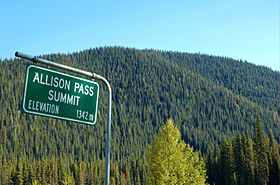
At the summit of Allison Pass
|
|
| Elevation | 1,342 m (4,403 ft) |
| Traversed by | Crowsnest Highway |
| Location | British Columbia, Canada |
| Range | Canadian Cascades |
| Coordinates | 49°7′N 120°52′W / 49.117°N 120.867°W |
Allison Pass is a high point along the Crowsnest Highway in British Columbia, Canada. It is like the top of a big hill or mountain that the highway goes over. This pass is the highest spot on the highway between the towns of Hope and Princeton.
It sits at an elevation of 1,342 m or 4,403 ft above sea level. Allison Pass is located right in the middle of a beautiful place called Manning Park. It also marks a natural boundary between two important river systems: the Skagit River and the Similkameen River. The Skagit River actually starts at the pass, while the Similkameen River begins just north of it.
Where is Allison Pass Located?
Allison Pass is found in the southern part of British Columbia. It is about 12 km (7 mi) west of the Manning Resort. It is also about 54 km (34 mi) away from the town of Hope. The pass also marks the border between two regional districts: the Fraser Valley and Okanagan-Similkameen.
Why is Allison Pass a Challenge?
Driving or cycling over Allison Pass can be quite difficult. The roads leading up to the pass are very steep. For example, on the way from Hope, you have to climb hills with a 7% grade. This means for every 100 feet you travel forward, you go up 7 feet.
These steep climbs and the high altitude make it tough for vehicles. Many large trucks often have to pull over to the side of the road. They wait for their engines to cool down before they can continue their journey.
History of the Pass
Allison Pass was named after a man named John Fall Allison. He was a rancher who lived in the nearby town of Princeton.
 | Madam C. J. Walker |
 | Janet Emerson Bashen |
 | Annie Turnbo Malone |
 | Maggie L. Walker |

