Fraser Valley Regional District facts for kids
Quick facts for kids
Fraser Valley
|
||
|---|---|---|
|
Regional district
|
||
| Fraser Valley Regional District | ||

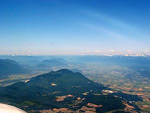
View departing Abbotsford Airport
|
||
|
||

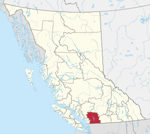
Location in British Columbia
|
||
| Country | Canada | |
| Province | British Columbia | |
| Administrative office location | Chilliwack | |
| Government | ||
| • Type | Regional district | |
| • Body | Board of Directors | |
| Area | ||
| • Land | 13,335.28 km2 (5,148.78 sq mi) | |
| Population
(2016)
|
||
| • Total | 295,934 | |
| • Density | 22.2/km2 (57/sq mi) | |
| Website | fvrd.bc.ca | |
The Fraser Valley Regional District (FVRD) is a special area in British Columbia, Canada. It's like a big county that helps manage services for many towns and rural areas. Its main office is in Chilliwack. The FVRD is huge, covering about 13,361 square kilometers (5,159 square miles)!
It was created in 1995 by joining a few smaller districts. The FVRD is the third most populated regional district in British Columbia. It covers the eastern part of the Lower Mainland area. It borders Whatcom County, Washington to the south and Metro Vancouver to the west.
Contents
Population and People
The FVRD is home to many people. In 2016, about 295,934 people lived here. This number grew by eight percent from 2011. The FVRD includes six main towns and eight "electoral areas." These electoral areas are places that are not part of a town.
Population Growth in the Fraser Valley
Here's how the population has changed in the main towns and electoral areas:
| Area | Population (2006) | Population (2011) | Population (2016) |
|---|---|---|---|
| City of Abbotsford | 123,864 | 133,497 | 141,397 |
| City of Chilliwack | 69,217 | 77,936 | 83,788 |
| District of Mission | 34,505 | 36,426 | 38,833 |
| District of Hope | 6,185 | 5,969 | 6,181 |
| District of Kent | 4,738 | 5,664 | 6,067 |
| Village of Harrison Hot Springs | 1,573 | 1,468 | 1,468 |
| Electoral Area "A" | 478 | 442 | 405 |
| Electoral Area "B" | 796 | 721 | 915 |
| Electoral Area "C" | 952 | 973 | 1,023 |
| Electoral Area "D" | 1,296 | 1,346 | 1,529 |
| Electoral Area "E" | 3,481 | 3,358 | 1,540 |
| Electoral Area "F" | 1,339 | 1,303 | 1,293 |
| Electoral Area "G" | 1,914 | 1,764 | 1,776 |
| Electoral Area "H" | 394 | N/A (dissolved) | 1,847 |
| Indian Reservations | 7,872 |
Languages Spoken in the Fraser Valley
The Fraser Valley is a diverse place with many languages spoken. Most people speak English at home. However, many other languages are also common.
Punjabi is the second most common language. Other languages include German, Dutch, and French. This shows the rich mix of cultures in the area.
| Mother tongue | Population (2011) | Percentage |
|---|---|---|
| English | 209,130 | 76.47% |
| Punjabi | 27,390 | 10.02% |
| German | 9,540 | 3.49% |
| Dutch | 3,790 | 1.39% |
| French | 2,915 | 1.07% |
| Korean | 1,880 | 0.69% |
| Spanish | 1,810 | 0.66% |
| Tagalog (Filipino) | 950 | 0.35% |
| Chinese, n.o.s. | 890 | 0.33% |
| Vietnamese | 820 | 0.30% |
Community Services
While cities and towns handle their own local services, the FVRD acts as the local government for the "electoral areas." These are rural places not part of any city. The FVRD helps provide many important services to these areas.
Some of these services include:
- Water pipes and storm drains
- Street lighting
- Garbage collection
- Fire protection
- Emergency services (like 911)
- Park maintenance
- Building inspections
- Planning for new developments
Not every area gets all these services. People in each electoral area pay property taxes based on the services they receive. The FVRD also has a plan for how the region will grow in the future.
How the Government Works
The FVRD government is made up of representatives from its member cities and electoral areas. It's like a team where each part of the region has a say.
- Cities and Towns: Each city or town appoints people (councillors) to the FVRD board. The number of people they send depends on how many residents live in their city.
- Electoral Areas: People living in the rural electoral areas directly elect one director for their area.
This system ensures that both city residents and rural residents have a voice in how the Fraser Valley Regional District is run.
Economy and Jobs
The Fraser Valley's economy has grown around natural resources. These include farming, logging, and gravel mining. A lot of the land in the Fraser Valley is protected for farming. This is called the Agricultural Land Reserve (ALR).
Tourism and recreation are also very important. Many people visit for campgrounds, RV parks, boating, and skiing. Most businesses and factories are located within the city limits. This helps keep the rural areas open for farming and homes.
Electoral Areas and Geography
"Electoral areas" are parts of the regional district that are not officially towns or cities. They are often more rural. The FVRD has eight of these areas, each with its own unique geography and communities.
Electoral Area "A"
This area includes the small towns of Boston Bar and North Bend. Each has about 200 people. Other residents live in small neighborhoods or on Indigenous reserves along the Fraser Canyon.
Electoral Area "B"
This area is connected by three major highways. Communities like Dogwood Valley, Emory Creek, and Choate are just north of Hope. Sunshine Valley is another community here. It was once a Japanese internment camp called Tashme.
Electoral Area "C"
Communities here include Lake Errock and Harrison Mills. There's also a resort town called Hemlock Valley, which is popular for skiing. Many people have vacation homes on islands in Harrison Lake.
Electoral Area "D"
The people in this area live in the villages of Popkum and Bridal Falls. Together, they have about 972 residents.
Electoral Area "E"
The Chilliwack River flows through this area. Most people live in the small space between the mountains and the river. This area is divided into places like Slesse Park and Baker Trails. Some residents also live near Cultus Lake or in the Columbia Valley.
Electoral Area "F"
Area F is located between several other regional districts and cities. Most of its 1,300 residents live in the southern, lower parts of the area. This lowland area is also known as Hatzic Valley. It includes places like McConnell Creek and Durieu.
Electoral Area "G"
This area is small but has about 1,800 people. It's mostly north of the Fraser River. It includes communities like Hatzic Island, Dewdney, Nicomen Island, and Deroche. Farming, forestry, and recreation are the main activities here.
Electoral Area "H"
This electoral area was re-established in 2014. It now includes Cultus Lake and Columbia Valley. Before 2008, it was a different area covering most of Sumas Mountain.
Geography of the Fraser Valley
- Pacific Ranges - These are the mountains that make up the northern half of the district.
- Fraser Valley - This is the river valley that forms the southern half of the district.
 | Audre Lorde |
 | John Berry Meachum |
 | Ferdinand Lee Barnett |

