Pacific Ranges facts for kids
Quick facts for kids Pacific Ranges |
|
|---|---|
| French: Chaînons du Pacifique | |

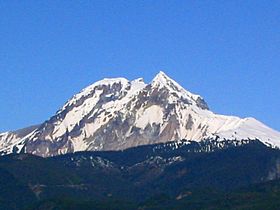
Mount Garibaldi massif as seen from Squamish
|
|
| Highest point | |
| Peak | Mount Waddington |
| Elevation | 4,019 m (13,186 ft) |
| Dimensions | |
| Area | 108,237 km2 (41,791 sq mi) |
| Geography | |
| Location | British Columbia, Canada |
| Parent range | Coast Mountains |
The Pacific Ranges are a huge group of mountains in British Columbia, Canada. They are the most southern part of the Coast Mountains, which are a big mountain chain along the Pacific Ocean. These ranges stretch from the Fraser River in the south all the way up to Bella Coola in the northwest. They sit between the Interior Plateau (a high, flat area) and the beautiful coastline of British Columbia.
The Pacific Ranges are home to four of the five largest coastal icecaps in the southern Coast Mountains. These are the biggest icecaps in the world found in places with mild temperatures. They feed many very large rivers. This area also includes Mount Waddington, which is the highest mountain completely within British Columbia. You can also find Hunlen Falls here, one of Canada's highest waterfalls, located in Tweedsmuir South Provincial Park.
Most of the land in the Pacific Ranges is wild and undeveloped. Some areas have logging, which is cutting down trees for wood. There are also hydroelectric projects that make electricity from water. A large ski resort is located at Whistler. In the past, mining was important in areas like Lillooet and Bridge River. Big paper mills also operated in places like Powell River. The largest power project is the Bridge River Power Project.
Contents
Understanding the Geology of the Pacific Ranges
The Pacific Ranges are part of a large rock formation called the Coast Plutonic Complex. Over the last 4 million years, these mountains have been pushed up very quickly. This fast uplift has also caused a lot of erosion, which is when rock and soil are worn away by wind and water.
Volcanoes in the Pacific Ranges
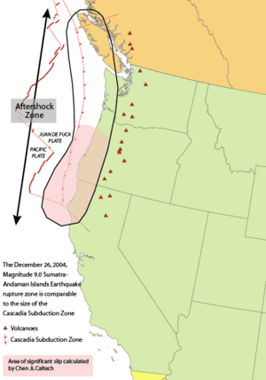
The Garibaldi Volcanic Belt is found within the Pacific Ranges. This belt is a chain of volcanoes formed by a process called subduction. This happens when one of Earth's large plates, the Juan de Fuca Plate, slides underneath another plate, the North American Plate. This sliding happens along the Cascadia subduction zone.
The Garibaldi Volcanic Belt is the northern part of the Cascade Volcanic Arc in the United States. This arc includes famous volcanoes like Mount St. Helens and Mount Baker. The volcanoes in the Garibaldi belt are some of the most explosive young volcanoes in Canada. They can erupt in different ways, from slow flows of lava to huge explosions. The lava can be thick or thin.
Because of many ice ages, the volcanic rocks in this area show how magma (melted rock) interacted with the land and changing ice. The biggest recent eruption in the Garibaldi Volcanic Belt happened about 2,350 years ago from the Mount Meager massif. This was Canada's most recent major volcanic eruption.
The Garibaldi Volcanic Belt also includes two other volcanic areas: the Franklin Glacier Complex and the Silverthrone Caldera. These are located northwest of the main volcanic belt.
The Cascadia Subduction Zone
The Cascadia subduction zone is a very long fault (a crack in the Earth's crust) that is about 1,094 kilometers (680 miles) long. It runs about 80 kilometers (50 miles) off the west coast of the Pacific Northwest, from northern California to Vancouver Island. The plates in this area move slowly, about 10 millimeters (0.4 inches) per year.
Unlike most subduction zones around the world, there isn't a deep oceanic trench along the coast in Cascadia. Instead, land pieces and built-up sediment have created a series of coastal mountains. A lot of sediment from major rivers like the Fraser River, Columbia River, and Klamath River also helps to hide any trench.
However, like other subduction zones, the outer edge of the land is slowly being squeezed, like a giant spring. When this stored energy is suddenly released, it can cause very large earthquakes. For example, the Cascadia subduction zone caused a massive earthquake in 1700, which was between 8.7 and 9.2 on the magnitude scale.
Major Mountain Ranges within the Pacific Ranges
The Pacific Ranges are made up of many smaller mountain groups. Here are some of the main ones:
- Niut Range
- Pantheon Range
- Waddington Range
- Whitemantle Range
- Chilcotin Ranges
- Bendor Range
- Lillooet Ranges
- Cayoosh Range
- Cantilever Range
- Douglas Ranges
- Garibaldi Ranges
- North Shore Mountains (Front Ranges)
- Tantalus Range
- Clendinning Range
Major Icefields of the Pacific Ranges
These are huge areas covered in ice and snow. Some are also considered mountain ranges themselves because of their unique features.
- Monarch Icefield
- Ha-Iltzuk Icefield (also known as Silverthrone Glacier)
- Waddington Range
- Homathko Icefield
- Lillooet Icecap (also called Lillooet Crown)
- Pemberton Icecap
Important Peaks in the Pacific Ranges
Here are some of the most notable mountains in the Pacific Ranges:
- Mount Waddington
- Monarch Mountain
- Mount Tiedemann
- Mount Munday
- Mount Queen Bess
- Mount Good Hope
- Mount Raleigh
- Monmouth Mountain
- Mount Tatlow
- Taseko Mountain
- Mount Silverthrone
- Mount Meager massif
- Mount Cayley massif
- Mount Garibaldi
- Wedge Mountain
- Mount Bute
Provincial Parks to Explore
Many beautiful provincial parks are located within the Pacific Ranges, offering chances to see nature and wildlife.
- Garibaldi Provincial Park
- Golden Ears Provincial Park
- Cypress Provincial Park
- Mount Seymour Provincial Park
- Sasquatch Provincial Park
- Stein Valley Nlaka'pamux Heritage Park
- Birkenhead Lake Provincial Park
- Big Creek Provincial Park
- Spruce Lake Protected Area
- Tsʼilʔos Provincial Park
- Tweedsmuir North Provincial Park and Protected Area
- Tweedsmuir South Provincial Park
Major Rivers Flowing Through the Pacific Ranges
These rivers are important for the region's environment and history.
- Fraser River
- Chilcotin River
- Bridge River
- Lillooet River
- Squamish River
- Homathko River
- Klinaklini River
- Bella Coola River
See also
 In Spanish: Montañas del Pacífico para niños
 | Madam C. J. Walker |
 | Janet Emerson Bashen |
 | Annie Turnbo Malone |
 | Maggie L. Walker |


