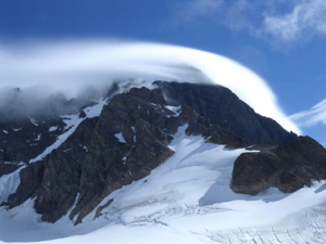
Monarch Mountain facts for kids
Quick facts for kids Monarch Mountain |
|
|---|---|
| Highest point | |
| Elevation | 3,555 m (11,663 ft) |
| Prominence | 2,930 m (9,610 ft) |
| Listing |
|
| Geography | |
| Location | British Columbia, Canada |
| Parent range | Pacific Ranges of the Coast Mountains |
| Topo map | NTS 92N/13 |
| Climbing | |
| First ascent | 1936 by Henry S. Hall Jr. and Hans Fuhrer |
| Easiest route | rock/ice climb |
Monarch Mountain is a very tall mountain in British Columbia, Canada. It's one of the main peaks in the Pacific Ranges, which are part of the larger Coast Mountains. This impressive mountain is located just east of a pass between two rivers: the Klinaklini River and the south branch of the Atnarko River. The Atnarko River flows into the Bella Coola River.
Around Monarch Mountain, you'll find the Monarch Icefield. This is the northernmost of the big icefields in the Pacific Ranges. Just south of it is the Ha-Iltzuk Icefield, which is actually the largest one. Monarch Mountain is also located in the southern part of Tweedsmuir South Provincial Park, a beautiful natural area.
Climate at Monarch Mountain
The very top of Monarch Mountain has an ice cap climate. This type of climate is also known as a Köppen EF climate. In an ice cap climate, the average temperature is always below freezing, even in the warmest months. This means the mountain summit is covered in ice and snow all year round.
The weather on Monarch Mountain is very cold and snowy.
- Temperatures are usually below freezing, even in summer.
- The coldest months are January and February, with average temperatures around -14°C.
- The warmest months are July and August, but the average temperature is still below -1°C.
- The mountain gets a lot of snow and rain, especially from October to January.
- November is often the wettest month, with over 500 mm of precipitation.
| Climate data for Monarch Mountain Peak 1981-2010 (51.899 -125.876) | |||||||||||||
|---|---|---|---|---|---|---|---|---|---|---|---|---|---|
| Month | Jan | Feb | Mar | Apr | May | Jun | Jul | Aug | Sep | Oct | Nov | Dec | Year |
| Mean daily maximum °C (°F) | −9.7 (14.5) |
−11.2 (11.8) |
−10.8 (12.6) |
−10.4 (13.3) |
−5.9 (21.4) |
−2.9 (26.8) |
−0.2 (31.6) |
0.0 (32.0) |
−2.9 (26.8) |
−6.4 (20.5) |
−9.4 (15.1) |
−10.1 (13.8) |
−6.7 (20.0) |
| Daily mean °C (°F) | −11.9 (10.6) |
−14.0 (6.8) |
−14.3 (6.3) |
−13.1 (8.4) |
−8.5 (16.7) |
−5.3 (22.5) |
−2.5 (27.5) |
−1.2 (29.8) |
−3.3 (26.1) |
−8.3 (17.1) |
−12.2 (10.0) |
−12.7 (9.1) |
−8.9 (15.9) |
| Mean daily minimum °C (°F) | −14.1 (6.6) |
−16.7 (1.9) |
−17.8 (0.0) |
−15.9 (3.4) |
−11.1 (12.0) |
−7.7 (18.1) |
−4.8 (23.4) |
−2.4 (27.7) |
−3.6 (25.5) |
−10.2 (13.6) |
−15.0 (5.0) |
−15.2 (4.6) |
−11.2 (11.8) |
| Average precipitation mm (inches) | 399 (15.7) |
284 (11.2) |
297 (11.7) |
239 (9.4) |
85 (3.3) |
91 (3.6) |
79 (3.1) |
113 (4.4) |
163 (6.4) |
390 (15.4) |
504 (19.8) |
340 (13.4) |
2,984 (117.4) |
| Source: http://www.climatewna.com/ClimateBC_Map.aspx | |||||||||||||
 | Stephanie Wilson |
 | Charles Bolden |
 | Ronald McNair |
 | Frederick D. Gregory |


