Coast Mountains facts for kids
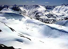
The Coast Mountains are a huge chain of mountains found along the western edge of North America. They stretch from southwestern Yukon through Alaska and almost all of the British Columbia Coast in Canada, down to the Fraser River. These mountains get their name because they are very close to the sea coast. People often call them the Coast Range.
This mountain range has both volcanic and non-volcanic peaks. It also includes huge areas covered in ice, called ice fields. The Coast Mountains are part of an even bigger mountain system. This system is known as the Pacific Coast Ranges. It includes other famous ranges like the Cascade Range and the Saint Elias Mountains. The Coast Mountains are also part of the American cordillera, which is a long, almost unbroken chain of mountains forming the western backbone of North and South America.
The Coast Mountains are about 1,600 kilometers (1,000 miles) long. They are also about 300 kilometers (190 miles) wide on average. To the south, they are bordered by the Fraser River and the Interior Plateau. In the far northwest, they end near the Kelsall River and Tatshenshini River.
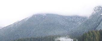
On their western side, the mountains are covered in thick, green temperate rainforests. They rise up to peaks that are heavily covered in glaciers. These glaciers form some of the largest ice fields in the world outside of the polar regions. On the eastern side, the mountains become drier. They lead into the Interior Plateau and the boreal forests of the Skeena Mountains.
The Coast Mountains are part of the Pacific Ring of Fire. This is a large circle of volcanoes and mountains around the Pacific Ocean. Some of British Columbia's tallest mountains are found here. Mount Waddington is the highest peak in the Coast Mountains. It is 4,019 meters (13,186 feet) tall. Mount Waddington is located entirely within British Columbia.
Contents
Exploring the Geography of the Coast Mountains
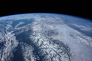
The Coast Mountains are divided into three main parts. These are the Pacific Ranges, the Kitimat Ranges, and the Boundary Ranges.
The Pacific Ranges: Southern Giants
The Pacific Ranges are the southernmost part of the Coast Mountains. They stretch from the Fraser River up to Bella Coola. This area has four of the five largest coastal icecaps in the southern Coast Mountains. These are the biggest temperate-latitude icecaps on Earth. They feed many large rivers. Besides some logging and a big ski resort in Whistler, most of this land is untouched. Mount Waddington, the highest mountain in the Coast Mountains, is found here.
The Kitimat Ranges: Central Wonders
Just north of the Pacific Ranges are the Kitimat Ranges. This central section goes from the Bella Coola River in the south to the Nass River in the north.
The Boundary Ranges: Northern Expanses
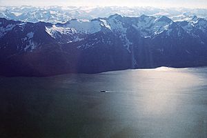
The Boundary Ranges are the northernmost and largest part of the Coast Mountains. They extend from the Nass River north into Yukon. They also cross the border into Alaska. This area includes huge ice fields. Examples are the Juneau Icefield and the Stikine Icecap.
How the Mountains Affect Weather
Because the Coast Mountains are right next to the Pacific Ocean, they greatly influence British Columbia's weather. Air full of moisture from the Pacific Ocean hits the mountains. This forces the air to rise. As it rises, it cools and drops heavy rain on the western slopes. This is why these slopes have lush, green forests. This area gets some of the most rainfall in North America. The eastern slopes are much drier and less steep. They protect the British Columbia Interior from the Pacific weather. This results in dry, warm summers and dry, cold winters.
East of the mountains is a large flat area called the Interior Plateau. This plateau covers a huge part of southern and central British Columbia. It includes layers of hardened lava flows from ancient volcanoes. North of this plateau are other mountain areas. These include the Skeena Mountains, Cassiar Mountains, and Hazelton Mountains.
How the Coast Mountains Were Formed
The Coast Mountains are made of old, changed rocks. These rocks came from different places around the world. The area is built from several pieces of Earth's crust, called terranes. Each terrane has a different age and origin.
In the southern part of the range, the oceanic crust under the Pacific Ocean is slowly sliding under the North American continent. This process is called subduction. It creates a line of volcanoes known as the Garibaldi Volcanic Belt. This belt is a northern part of the Cascade Volcanic Arc in the United States. It has some of Canada's most explosive young volcanoes. Further north, the Coast Mountains also have volcanoes formed by a large crack in the continent, called a rift. These volcanoes are part of the Northern Cordilleran Volcanic Province. This is the most volcanically active area in Canada.
Ancient Volcanic Islands and Collisions
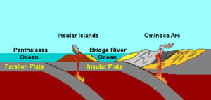
About 130 million years ago, a group of active volcanic islands moved closer to the coast of North America. These islands, called the Insular Islands, were on a tectonic plate known as the Insular Plate. This plate was moving east. There was an ancient ocean basin between these islands and North America, called the Bridge River Ocean.
As the Insular Plate moved closer, the Bridge River Ocean slowly closed. About 115 million years ago, this ocean completely disappeared. The Insular Islands then crashed into the old coast of North America. This collision pushed and folded the rocks along the coast. The islands then became a permanent part of the continent. This created a new, larger coastline. Huge amounts of molten rock, called magma, then cooled to form a massive block of granite. This granite block is the largest of its kind in North America.
The Coast Range Arc: A New Volcanic Era
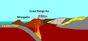
After the Insular Islands joined the continent, the Farallon Plate continued to slide under this new coastline. This started a new chain of volcanoes about 100 million years ago. This chain is called the Coast Range Arc. Magma from the Farallon Plate rose through the newly added land. It injected huge amounts of granite into older rocks. New volcanoes formed on the surface along the coast.
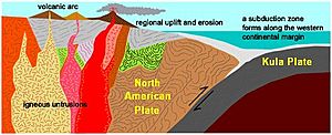
Around 85 million years ago, a part of the Farallon Plate broke off. This new piece was called the Kula Plate. This change had a big effect on the region. Volcanic activity in the Coast Range Arc increased again. Large parts of the arc were lifted up. This began a period of mountain building called the Laramide orogeny. During this time, huge amounts of molten granite pushed into old ocean rocks. These molten rocks heated and squeezed the old ocean sediments. This turned them into a shiny, layered rock called schist. Older granite rocks were also changed by heat and pressure. They became another layered rock called gneiss. In some places, the rocks were so hot and squeezed that they almost melted. This created unusual swirled patterns called migmatite.
Volcanic activity in the Coast Range Arc started to slow down about 60 million years ago. This was because the Kula Plate began to move more to the north. Instead of sliding under the Pacific Northwest, it started sliding under parts of Yukon and Alaska. By about 50 million years ago, all volcanic activity along the Coast Range Arc stopped. Many of the old volcanoes have since worn away due to erosion. What we see today as the Coast Mountains are mainly the granite rocks that cooled deep beneath those ancient volcanoes.
Tallest Peaks in the Coast Mountains
| Mountain/Peak | Height (metres) | Prominence (metres) | Height (feet) | Prominence (feet) | Location |
|---|---|---|---|---|---|
| Mount Waddington | 4019 | 3289 | 13,186 | 10,791 |
51°22.3′N 125°15.7′W / 51.3717°N 125.2617°W |
| Monarch Mountain | 3555 | 2930 | 11,663 | 9,613 |
51°54.0′N 125°52.6′W / 51.9000°N 125.8767°W |
| Skihist Mountain | 2968 | 2463 | 9,738 | 8,081 |
50°11.3′N 121°54.2′W / 50.1883°N 121.9033°W |
| Mount Ratz | 3090 | 2430 | 10,138 | 7,972 |
57°23.6′N 132°18.2′W / 57.3933°N 132.3033°W |
| Mount Queen Bess | 3298 | 2355 | 10,820 | 7,726 |
51°16.3′N 124°34.1′W / 51.2717°N 124.5683°W |
| Razorback Mountain | 3183 | 2253 | 10,295 | 7,392 |
51°35.4′N 124°41.5′W / 51.5900°N 124.6917°W |
| Wedge Mountain | 2892 | 2249 | 9,488 | 7,379 |
50°08.0′N 122°47.6′W / 50.1333°N 122.7933°W |
| Otter Mountain | 2692 | 2242 | 8,832 | 7,356 |
56°00.4′N 129°41.6′W / 56.0067°N 129.6933°W |
| Kwatna Peak | 2290 | 2225 | 7,513 | 7,300 |
52°04.2′N 126°57.6′W / 52.0700°N 126.9600°W |
| Scud Peak | 2987 | 2172 | 9,800 | 7,126 |
57°14.5′N 131°10.1′W / 57.2417°N 131.1683°W |
Mountain Ranges within the Coast Mountains
| Range Name | Parent | Region(s) | Country |
|---|---|---|---|
| Boundary Ranges | Coast Mountains | British Columbia, Yukon, Alaska | Canada, United States |
| Boundary Range | Boundary Ranges | British Columbia, Alaska | Canada, United States |
| Adam Mountains | Boundary Ranges | Alaska | United States |
| Ashington Range | Boundary Ranges | British Columbia | Canada |
| Burniston Range | Boundary Ranges | British Columbia | Canada |
| Dezadeash Range | Boundary Ranges | Yukon | Canada |
| Florence Range | Boundary Ranges | British Columbia | Canada |
| Halleck Range | Boundary Ranges | Alaska | United States |
| Juneau Icefield | Boundary Ranges | British Columbia, Alaska | Canada, United States |
| Sawtooth Range | Juneau Icefield | Alaska | United States |
| Kakuhan Range | Boundary Ranges | Alaska | United States |
| Lincoln Mountains | Boundary Ranges | Alaska | United States |
| Longview Range | Boundary Ranges | British Columbia | Canada |
| Peabody Mountains | Boundary Ranges | Alaska | United States |
| Rousseau Range | Boundary Ranges | Alaska | United States |
| Seward Mountains | Boundary Ranges | Alaska | United States |
| Snowslide Range | Boundary Ranges | British Columbia | Canada |
| Spectrum Range | Boundary Ranges | British Columbia | Canada |
| Stikine Icecap | Boundary Ranges | British Columbia, Alaska | Canada, United States |
| Chechidla Range | Stikine Icecap | British Columbia | Canada |
| Cheja Range | Stikine Icecap | British Columbia | Canada |
| Kitimat Ranges | Coast Mountains | British Columbia | Canada |
| Bare Top Range | Kitimat Ranges | British Columbia | Canada |
| Countess of Dufferin Range | Kitimat Ranges | British Columbia | Canada |
| Kitlope Range | Kitimat Ranges | British Columbia | Canada |
| North Coastal Archipelago | Kitimat Ranges | British Columbia | Canada |
| Bell Range | North Coastal Archipelago | British Columbia | Canada |
| Burnaby Range | North Coastal Archipelago | British Columbia | Canada |
| Cape Range | North Coastal Archipelago | British Columbia | Canada |
| Chismore Range | North Coastal Archipelago | British Columbia | Canada |
| Murphy Range | North Coastal Archipelago | British Columbia | Canada |
| Richardson Range | North Coastal Archipelago | British Columbia | Canada |
| Spiller Range | North Coastal Archipelago | British Columbia | Canada |
| Williams Range | North Coastal Archipelago | British Columbia | Canada |
| Wimbledon Range | North Coastal Archipelago | British Columbia | Canada |
| Tenaiko Range | Kitimat Ranges | British Columbia | Canada |
| Pacific Ranges | Coast Mountains | British Columbia | Canada |
| Ashlu-Elaho Divide | Pacific Ranges | British Columbia | Canada |
| Bazalgette Range | Pacific Ranges | British Columbia | Canada |
| Bendor Range | Pacific Ranges | British Columbia | Canada |
| Bridge-Lillooet Divide | Pacific Ranges | British Columbia | Canada |
| Broughton Archipelago | Pacific Ranges | British Columbia | Canada |
| Calliope Range | Broughton Archipelago | British Columbia | Canada |
| Georgina Range | Broughton Archipelago | British Columbia | Canada |
| Bunster Range | Pacific Ranges | British Columbia | Canada |
| Cadwallader Range | Pacific Ranges | British Columbia | Canada |
| Caren Range | Pacific Ranges | British Columbia | Canada |
| Charlotte Alplands | Pacific Ranges | British Columbia | Canada |
| Douglas Ranges | Pacific Ranges | British Columbia | Canada |
| Chilcotin Ranges | Pacific Ranges | British Columbia | Canada |
| Camelsfoot Range | Chilcotin Ranges | British Columbia | Canada |
| Dickson Range | Chilcotin Ranges | British Columbia | Canada |
| Leckie Range | Chilcotin Ranges | British Columbia | Canada |
| Pantheon Range | Chilcotin Ranges | British Columbia | Canada |
| Potato Range | Chilcotin Ranges | British Columbia | Canada |
| Shulaps Range | Chilcotin Ranges | British Columbia | Canada |
| Clendinning Range | Pacific Ranges | British Columbia | Canada |
| Colville Range | Pacific Ranges | British Columbia | Canada |
| Conical Range | Pacific Ranges | British Columbia | Canada |
| Earle Range | Pacific Ranges | British Columbia | Canada |
| Edwards Range | Pacific Ranges | British Columbia | Canada |
| Florence Range | Pacific Ranges | British Columbia | Canada |
| Franklyn Range | Pacific Ranges | British Columbia | Canada |
| Fraser Range | Pacific Ranges | British Columbia | Canada |
| Garibaldi Ranges | Pacific Ranges | British Columbia | Canada |
| Garibaldi Névé | Garibaldi Ranges | British Columbia | Canada |
| Fitzsimmons Range | Garibaldi Ranges | British Columbia | Canada |
| McBride Range | Garibaldi Ranges | British Columbia | Canada |
| Spearhead Range | Garibaldi Ranges | British Columbia | Canada |
| Golden Ears | Garibaldi Ranges | British Columbia | Canada |
| Misty Icefield | Garibaldi Ranges | British Columbia | Canada |
| Bastion Range | Garibaldi Ranges | British Columbia | Canada |
| Gastineau Range | Pacific Ranges | British Columbia | Canada |
| Ha-Iltzuk Icefield | Pacific Ranges | British Columbia | Canada |
| Homathko Icefield | Pacific Ranges | British Columbia | Canada |
| Koeye Range | Pacific Ranges | British Columbia | Canada |
| Lewis Range | Pacific Ranges | British Columbia | Canada |
| Lillooet Icecap | Pacific Ranges | British Columbia | Canada |
| Compton Névé | Lillooet Icefield | British Columbia | Canada |
| Lillooet Ranges | Pacific Ranges | British Columbia | Canada |
| Cantilever Range | Lillooet Ranges | British Columbia | Canada |
| Cayoosh Range | Lillooet Ranges | British Columbia | Canada |
| Mission Ridge | Pacific Ranges | British Columbia | Canada |
| Monarch Icefield | Pacific Ranges | British Columbia | Canada |
| North Shore Mountains | Pacific Ranges | British Columbia | Canada |
| Fannin Range | North Shore Mountains | British Columbia | Canada |
| Britannia Range | North Shore Mountains | British Columbia | Canada |
| Namu Range | Pacific Ranges | British Columbia | Canada |
| Nicholl Range | Pacific Ranges | British Columbia | Canada |
| Niut Range | Pacific Ranges | British Columbia | Canada |
| Pemberton Icefield | Pacific Ranges | British Columbia | Canada |
| Pembroke Range | Pacific Ranges | British Columbia | Canada |
| Powell Divide | Pacific Ranges | British Columbia | Canada |
| Sir Harry Range | Pacific Ranges | British Columbia | Canada |
| Squamish-Cheakamus Divide | Pacific Ranges | British Columbia | Canada |
| Tantalus Range | Pacific Ranges | British Columbia | Canada |
| The Tahumming | Pacific Ranges | British Columbia | Canada |
| Tottenham Range | Pacific Ranges | British Columbia | Canada |
| Unwin Range | Pacific Ranges | British Columbia | Canada |
| Waddington Range | Pacific Ranges | British Columbia | Canada |
| Wharncliffe Range | Pacific Ranges | British Columbia | Canada |
| Whitemantle Range | Pacific Ranges | British Columbia | Canada |
See also
 In Spanish: Montañas Costeras para niños
 | Lonnie Johnson |
 | Granville Woods |
 | Lewis Howard Latimer |
 | James West |


