Nass River facts for kids
Quick facts for kids Nass River |
|
|---|---|

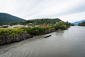
View west on Nass River at Gitwinksihlkw
|
|

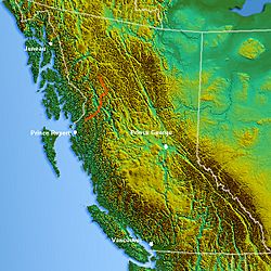
Location map of the Nass River
|
|
| Country | Canada |
| Province | British Columbia |
| Physical characteristics | |
| Main source | Nass Lake Klappan Range, Skeena Mountains 1,058 m (3,471 ft) 57°9′59″N 129°6′8″W / 57.16639°N 129.10222°W |
| River mouth | Nass Bay Portland Inlet 54°58′37″N 129°53′22″W / 54.97694°N 129.88944°W |
| Length | 380 km (240 mi) |
| Basin features | |
| Basin size | 20,839 km2 (8,046 sq mi) |
The Nass River is a long river in northern British Columbia, Canada. It flows for about 380 kilometers (236 miles) from the Coast Mountains southwest to Nass Bay. This bay is a side part of Portland Inlet, which connects to the North Pacific Ocean.
The English name "Nass" comes from the Tlingit language. It means "intestines" or "guts." This refers to how much fish the river provides. It can also mean "food depot." The Nisga'a name for the river is K'alii Aksim Lisims. Lisims means "murky," describing the river's cloudy water.
The last 40 kilometers (25 miles) of the river are easy to travel by boat. The river is very important for catching salmon for business. The area around the Nass River is where the first modern land agreement happened in British Columbia. This agreement was between the government and the Nisga'a Nation. The name Nisga'a means "people of the Nass River."
Contents
History of the Nass River Valley
About 220 years ago, a big event happened near the Nass River. The Nisga'a people have stories about it. A huge lava flow came from the Tseax Cone volcano. This lava flow was about 22.5 kilometers (14 miles) long. It blocked the Nass River and destroyed Nisga'a villages. At least 2,000 Nisga'a people died from volcanic gases and smoke.
This volcano has erupted at least two times in the last 1,000 years. One eruption was 220 years ago, and another was 650 years ago. Because we know about these past events, scientists now watch volcanoes. They study the gases volcanoes release. This helps them create warning systems for people living near volcanoes.
Potential Hazards from Tseax Cone
If the Tseax Cone volcano erupts again, it could cause problems. There could be poisonous gas, just like 220 years ago. An eruption could also start forest fires. Large lava flows might block rivers like the Nass River and the Tseax. If lava reaches the Nass River again, it could harm the important salmon fishing in the river system. This would have serious short-term effects.
Nass River Tributaries
Here is a list of rivers that flow into the Nass River, starting from the mouth and going upstream:
- Xnukw (Iknouk River)
- Ksi Hlginx (Ishkheenickh River)
- Ksi Sii Aks (Tseax River)
- Ksi Gwinhat'al (Kwinatahl River)
- Tchitin River
- Kinskuch River
- Cranberry River
- Kiteen River
- White River
- Flat River
- Meziadin River, Meziadin Lake
- Bell-Irving River
- Kwinageese River
- Taylor River
- West Taylor River
See also
 In Spanish: Río Nass para niños
 | Jackie Robinson |
 | Jack Johnson |
 | Althea Gibson |
 | Arthur Ashe |
 | Muhammad Ali |


