
Cascade Volcanic Arc facts for kids
Quick facts for kids Cascades Volcanoes |
|
| Volcanic arc | |
 Mount Rainier from the northeast
|
|
| Countries | United States, Canada |
|---|---|
| Provinces/States | Oregon, Washington, California, British Columbia |
| Highest point | Mount Rainier |
| - elevation | 14,411 ft (4,392 m) |
| - coordinates | 46°51′1.9″N 121°45′35.6″W / 46.850528°N 121.759889°W |
| Period | Eocene-to-Holocene |
The Cascade Volcanoes are a chain of volcanoes in western North America. They stretch for over 700 miles (1,100 km) from southwestern British Columbia in Canada, through Washington and Oregon, and into Northern California in the United States. This chain of volcanoes formed because of something called subduction. This is where one of Earth's large plates, the Cascadia subduction zone, slides under another.
Even though they are named after the Cascade Range, these volcanoes are a geological group. This means they are linked by how they formed, not just where they are on a map. The Cascade Volcanoes actually go further north into the Coast Mountains, past the Fraser River.
Many big cities like Portland, Seattle, and Vancouver are near these volcanoes. More than 10 million people live in this area. All these people could be affected by volcanic eruptions or big earthquakes. Because more and more people are moving to the Pacific Northwest, the Cascade volcanoes are considered quite dangerous. This is due to their past eruptions and the chance of future ones.
Mount Rainier is one of the "Decade Volcanoes." These are volcanoes that scientists study closely because they pose a big risk to nearby cities like Seattle and Tacoma. Many large landslides have happened on Cascade volcanoes. These slides have covered valleys far away from the volcanoes. Some of these areas are now home to many people.
The Cascade Volcanoes are part of the Pacific Ring of Fire. This is a large ring of volcanoes and mountains around the Pacific Ocean. The Cascade Volcanoes have erupted many times in recorded history. The most recent big eruptions were Lassen Peak (1914-1921) and a huge eruption of Mount St. Helens in 1980. Canada's most recent major eruption happened about 2,350 years ago at the Mount Meager volcanic complex.
Contents
What are Cascade Volcanoes like?
The Cascade Arc has almost 20 main volcanoes. But there are also over 4,000 other volcanic spots! These include many stratovolcanoes (cone-shaped), shield volcanoes (wide and flat), lava domes, and cinder cones (small, steep cones). There are also some rarer types like tuyas.
Volcano activity in this area started about 37 million years ago. However, most of the volcanoes we see today are less than 2 million years old. The very tallest peaks are even younger, less than 100,000 years old. Twelve volcanoes in the arc are over 10,000 feet (3,000 m) tall. The two highest are Mount Rainier and Mount Shasta, which are over 14,000 feet (4,300 m) high.
The two largest Cascade volcanoes by size are Medicine Lake Volcano and Newberry Volcano. They are very wide and flat, like shields.
Major Past Eruptions

The 1980 eruption of Mount St. Helens was one of the most studied volcano eruptions ever. It was a very powerful eruption, like a huge explosion. It was the biggest eruption in the lower 48 U.S. states in recorded history.
An earthquake on May 18, 1980, caused the entire north side of the mountain to slide away. A huge column of ash shot high into the sky. This ash fell in 11 U.S. states. The eruption sadly killed 57 people and thousands of animals. It also caused over a billion U.S. dollars in damage.
On May 22, 1915, an explosive eruption at Lassen Peak caused a lot of damage nearby. It rained volcanic ash as far as 200 miles (320 km) to the east. A giant column of ash and gas rose more than 30,000 feet (9,100 m) into the air. People could see it from Eureka, California, which is 150 miles (240 km) away.
A fast-moving flow of hot gas and rock, called a pyroclastic flow, rushed down the volcano's side. It destroyed an area of 3-square-mile (7.8 km2). This explosion was the strongest in a series of eruptions at Lassen Peak from 1914 to 1917.
Mount Meager had the most recent major eruption in Canada. It sent ash all the way to Alberta. This eruption was similar to the 1980 eruption of Mount St. Helens. It sent an ash column about 20 km (12 mi) high into the stratosphere. This eruption created many layers of volcanic rock. These layers can be seen along the Lillooet River.

The eruption of Mount Mazama about 7,700 years ago was a huge disaster in Oregon. It started with a large eruption column of pumice and ash. The eruption was so powerful that most of Mount Mazama collapsed. This created a large bowl-shaped hole called a caldera. Later, water filled this caldera to form Crater Lake. Volcanic ash from this eruption spread across most of the Pacific Northwest and parts of southern Canada.
About 13,000 years ago, Glacier Peak had a very strong series of eruptions. These eruptions left volcanic ash as far away as Wyoming.
Other Eruptions in the Cascades
The Silverthrone Caldera had most of its eruptions during the last ice age. It was active during different periods of volcano formation. This caldera is one of the largest in western Canada. It is about 30 kilometres (19 mi) long and 20 kilometres (12 mi) wide. The last eruption from Mount Silverthrone happened about 1,000 years ago.
Mount Cayley last erupted about 20,000 years ago. It has several complex features from different eruptions.
Mount Garibaldi was last active about 10,700 to 9,300 years ago. An area called Opal Cone produced a 15 km (9.3 mi) long lava flow. This lava flow was unusual because it was very long for its type.

Mount Baker erupted in the mid-1800s for the first time in thousands of years. Hot gas vents, called Fumaroles, are still active near the volcano's top. They became more intense in 1975. However, scientists do not expect an eruption soon.
Glacier Peak last erupted about 200–300 years ago. It has erupted about six times in the last 4,000 years.
Mount Rainier last erupted between 1824 and 1854. People also reported eruptions in 1858, 1870, 1879, 1882, and 1894. Mount Rainier has had at least four eruptions and many lahars (mudflows) in the last 4,000 years.
Mount Adams was last active about 1,000 years ago. It has had few eruptions in the last few thousand years. These eruptions created several major lava flows. Hot spots and gas releases have happened on the summit since 1921.
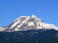
Mount Hood was last active about 200 years ago. It created pyroclastic flows and lahars. It also formed a lava dome called Crater Rock near its peak. From 1856 to 1865, steam explosions happened at Mount Hood.
A lot of volcanic activity has happened at Newberry Volcano. It was last active about 1,300 years ago. It has one of the largest collections of cinder cones, lava domes, lava flows, and cracks in the ground, called fissures, in the world.
Medicine Lake Volcano has erupted about eight times in the last 4,000 years. It was last active about 1,000 years ago.
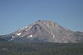
Mount Shasta last erupted in 1786. It has been the most active volcano in California for about 4,000 years, erupting about once every 300 years. The 1786 eruption created a pyroclastic flow and several lahars.
Eruptions in the Cascade Range
Eleven of the 13 volcanoes in the Cascade Range have erupted at least once in the last 4,000 years. Seven of them have erupted in just the past 200 years. The Cascade volcanoes have had over 100 eruptions in the last few thousand years. Many of these were explosive eruptions.
Some Cascade volcanoes can be quiet for hundreds or thousands of years between eruptions. This means the danger from volcanic activity in these areas is not always clear.
When Cascade volcanoes do erupt, pyroclastic flows, lava flows, and landslides can destroy areas over 10 miles (16 km) away. Huge mudflows of volcanic ash and debris, called lahars, can flood valleys over 50 miles (80 km) downstream. Falling ash from explosive eruptions can disrupt human activities hundreds of miles away. Clouds of fine ash can even damage jet aircraft thousands of miles away.
All known eruptions in recent history have happened in Washington, Oregon, and Northern California. The two most recent were Lassen Peak (1914-1921) and a major eruption of Mount St. Helens in 1980. Smaller eruptions of Mount St. Helens have also happened, most recently in 2006. Volcanoes in southern British Columbia and central/southern Oregon are currently quiet.
New volcanic activity in the Cascade Arc, like the 1980 eruption of Mount St. Helens, has taught scientists a lot. For example, it showed how much landslides and volcanic growth affect the landscape. A huge part of the north side of Mount St. Helens fell off. This created a jumbled landslide area several kilometers from the volcano. Pyroclastic flows and lahars moved across the land. Similar events have also happened at Mount Shasta and other Cascade volcanoes long ago.
List of Tallest Cascade Volcanoes
Washington state has most of the very tallest volcanoes. Four of the top six are there. However, Oregon has most of the next highest peaks. Even though Mount Rainier is the tallest, it is not the largest by size. Mount Shasta in California is the largest by size. Washington's Mount Adams is the second largest. Mount Rainier is the third largest by the amount of material it has erupted.
Here is a list of the tallest Cascade Volcanoes:
| Name | Elevation | State/Province | Location | Last eruption | ||
| feet | meters | Coordinates | ||||
| Mount Rainier | 14,411 | 4,392 | Washington | 46°51′10″N 121°45′37″W / 46.8528857°N 121.7603744°W | November to December 1894 | |
| Mount Shasta | 14,162 | 4,317 | California | 41°24′33″N 122°11′42″W / 41.409196033°N 122.194888358°W | 1786 | |
| Mount Adams | 12,280 | 3,740 | Washington | 46°12′09″N 121°29′27″W / 46.202411792°N 121.490894694°W | About 950 AD | |
| Mount Hood | 11,239 | 3,426 | Oregon | 45°22′25″N 121°41′45″W / 45.373514489°N 121.695918558°W | 1865 to 1866 | |
| Mount Baker | 10,781 | 3,286 | Washington | 48°46′38″N 121°48′48″W / 48.7773426°N 121.8132008°W | September to November 1880 | |
| Glacier Peak | 10,541 | 3,213 | Washington | 48°06′45″N 121°06′50″W / 48.112513950°N 121.113804642°W | 1700 ± 100 years | |
| Mount Jefferson | 10,497 | 3,199 | Oregon | 44°40′27″N 121°47′58″W / 44.674300600°N 121.799573611°W | About 950 AD | |
| Lassen Peak | 10,457 | 3,187 | California | 40°29′17″N 121°30′18″W / 40.4881731°N 121.5050078°W | 1914 to 1917 | |
| Saint Helens | 8,363 | 2,549 | Washington | 46°11′28″N 122°11′40″W / 46.19111°N 122.19444°W | 2008 | |
| Silverthrone Caldera | 10,370 | 3,160 | British Columbia | 51°26′00″N 126°18′00″W / 51.43333°N 126.30000°W | About 100,000 years ago | |
| South Sister | 10,358 | 3,157 | Oregon | 44°06′12″N 121°46′09″W / 44.1034490°N 121.7692058°W | 50 BC | |
| North Sister (Three Sisters) | 10,085 | 3,074 | Oregon | 44°09′58″N 121°46′21″W / 44.1662273°N 121.7725431°W | 100,000 yrs ago | |
| Middle Sister (Three Sisters) | 10,047 | 3,062 | Oregon | 44°08′53″N 121°47′02″W / 44.1481718°N 121.7839312°W | 14,000 yrs ago | |
| Mount McLoughlin | 9,495 | 2,894 | Oregon | 42°26′40″N 122°18′56″W / 42.44444°N 122.31556°W | About 30,000 years ago | |
Images for kids
-
Lassen Peak and Devastated Area from Cinder Cone
-
Mount Garibaldi as seen from Squamish
-
Mount Cayley as seen from its southeast slopes
-
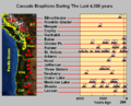
Major Cascade volcano eruptions in the last 4000 years
-
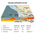
Cascadia earthquake sources
-
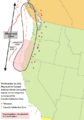
Area of the Cascadia subduction zone, including Cascade volcanoes (red triangles)


See also
 In Spanish: Arco volcánico de las Cascadas para niños
