
Mount Adams (Washington) facts for kids
Quick facts for kids Mount Adams |
|
|---|---|
| Pahto, Klickitat | |

Mount Adams from the west-northwest
|
|
| Highest point | |
| Elevation | 12,281 ft (3,743 m) NAVD 88 |
| Prominence | 8,116 ft (2,474 m) |
| Isolation | 46.1 mi (74.2 km) |
| Listing |
|
| Geography | |
| Location | Yakima County / Skamania County, Washington, U.S. |
| Parent range | Cascade Range |
| Topo map | USGS Mount Adams East |
| Geology | |
| Age of rock | Less than 520,000 years |
| Mountain type | Stratovolcano |
| Volcanic arc | Cascade Volcanic Arc |
| Last eruption | About 950 AD |
| Climbing | |
| First ascent | 1854 by A.G. Aiken and party |
| Easiest route | South Climb Trail #183 |
Mount Adams, also called Pahto or Klickitat by some Native American tribes, is a large, potentially active volcano in the Cascade Range. It is a type of volcano called a stratovolcano, which means it's tall and cone-shaped, built up by many layers of hardened lava, ash, and rocks. Even though Mount Adams has not erupted in over 1,000 years, scientists still consider it active.
Mount Adams is the second-highest mountain in the U.S. state of Washington, after Mount Rainier. It is part of the Cascade Volcanic Arc, a chain of volcanoes along the west coast of North America. Mount Adams is one of the biggest volcanoes in this arc. It sits in a wild, remote area, about 34 miles (55 km) east of Mount St. Helens.
The upper and western parts of Mount Adams are protected as the Mount Adams Wilderness. The eastern side of the mountain is part of the land belonging to the Yakama Nation.
Mount Adams has a wide, uneven shape, rising about 1.5 miles (2.4 km) above the nearby Cascade mountains. Its top looks almost flat because it was formed by eruptions from different openings. People flying over the area sometimes confuse Mount Adams with Mount Rainier because both mountains have similar flat tops. The Pacific Crest Trail, a famous long-distance hiking trail, goes along the western side of the mountain.
Contents
Where is Mount Adams Located?

Mount Adams is located about 37 miles (60 km) east of Mount St. Helens. It is also about 50 miles (80 km) south of Mount Rainier. The mountain is 30 miles (48 km) north of the Columbia River. It is also 55 miles (89 km) north of Mount Hood in Oregon.
The closest major cities are Yakima, which is 50 miles (80 km) to the northeast. The Portland area is about 60 miles (97 km) to the southwest.
Most of Mount Adams is inside the Mount Adams Wilderness. This wilderness area is part of the Gifford Pinchot National Forest. The rest of the mountain is within the Mount Adams Recreation Area. This recreation area is part of the Yakama Indian Reservation.
Mount Adams is the only active volcano in Washington that sits right on the Cascade Crest. This is the highest part of the Cascade Mountain Range. It is also farther east than most other volcanoes in Washington, except for Glacier Peak.
How Big is Mount Adams?

Mount Adams is one of the oldest volcanoes in the Cascade Range. Small volcanic activity started about 900,000 years ago. The main part of the mountain began forming about 520,000 years ago. Over time, glaciers have worn down the mountain twice. The current cone, or main shape, of the volcano was built between 40,000 and 10,000 years ago.
Mount Adams stands at 12,281 feet (3,743 m) tall. It rises about 9,800 feet (3,000 m) above the land around it. It is the second-highest mountain in Washington state. It is also the third-highest mountain in the entire Cascade Range.
Because of how it grew, Mount Adams is the largest stratovolcano in Washington. It is the second-largest in the Cascades, only smaller than Mount Shasta. Its huge size is clear from its base, which is about 18 miles (29 km) wide. This base stretches out more from north to south.
Rivers and Water from Mount Adams
Mount Adams is where two important rivers begin. These are the Lewis River and the White Salmon River. Many other streams flow from the mountain's glaciers and springs. These streams feed into two more major river systems: the Cispus River and the Klickitat River.
Streams on the north and west sides of Mount Adams flow into the Cispus River. The Cispus River then joins the Cowlitz River. Streams on the east side of the mountain all flow into the Klickitat River.
All these streams provide important irrigation water for farming and ranching in the area. The Klickitat and White Salmon rivers flow mostly freely. They only have small barriers to help with irrigation or to control erosion. The Cispus and Lewis rivers have dams built further downstream. These dams help control floods and generate power.
Getting to Mount Adams
Mount Adams is one of the most remote volcanoes in Washington. Only two main highways pass close to it. Highway 12 is about 25 miles north of Adams. Highway 141 gets within 13 miles of Adams. It follows the White Salmon River valley from the Columbia River up to the small town of Trout Lake.
To get closer to the mountain, visitors must use Forest Service roads. The main access roads, like FR 23, FR 82, FR 80, and FR 21, are paved for some parts. Most other roads are gravel or dirt and might not be well maintained.
Access to the Mount Adams Recreation Area is by FR 82. This road becomes BIA 285 at the Yakama reservation border. BIA 285 is known to be very rough. It is often only suitable for trucks or vehicles with high clearance.
Two small towns are located less than 15 miles from the summit. These are Glenwood and Trout Lake. Glenwood is on the southeast side, and Trout Lake is on the southwest side.
Because of its large size and distance from big cities, some people call Mount Adams "The Forgotten Giant of Washington."
Other Volcanoes You Can See
On a clear day from the top of Mount Adams, you can see many other volcanoes in the Cascade Range. To the north, in Washington, you might see Mount Rainier, Mount Baker, and Glacier Peak. To the west, you can see Mount St. Helens.
Looking south, you can see several volcanoes in Oregon. These include Mount Hood, Mount Jefferson, the Three Sisters, Mount Thielsen, Mount Scott, Diamond Peak, and Mount McLoughlin.
Images for kids
-
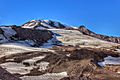
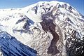
Heavily crevassed glaciers on the southeast side of the mountain
-
Glaciers of Mount Adams
-

Deep crevasses and icefalls on Adams Glacier
-
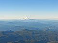
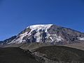
Aerial view of the south face from across the Columbia River Gorge
-
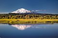
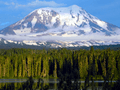
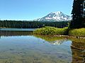
Trout Lake (Trout Lake Creek) reflecting Mount Adams near the small town of Trout Lake
-
Takh Takh Lava Flow below Mount Adams
-
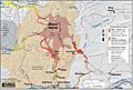
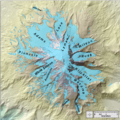
Mount Adams, Washington simplified hazards map showing potential impact area for ground-based hazards during a volcanic event.
-
Rock and ice debris avalanche that occurred on October 20, 1997, on the east side of Mount Adams.
-

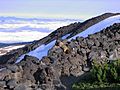
The South Climb, or South Spur climbing route on Mount Adams along Suksdorf Ridge
-
The Northeast face as seen from Devils Garden
-
High Camp at Killen Meadows, high on the slopes of Mount Adams. Adams Glacier cascades down the rocky chute from the summit icecap
-
Mount Adams and the Mazama Glacier from Bird Creek Meadows, in the Mount Adams Recreation Area.
-
Adams Glacier descends from the summit ice cap near the center of this view from the northwest.
-
Takhlakh Lake on the northwest side of Mount Adams
-
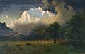
Albert Bierstadt, Mount Adams, Washington, 1875, Princeton University Art Museum
-
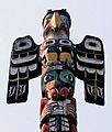
Thunderbird on a Totem Pole
-
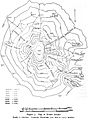
Reid's map from his survey of Adams in 1901
-
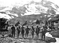
Cascadians climbing party before starting the ascent of the east side of Adams
-
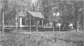
Gotchen Creek Guard Station ca. 1911
-
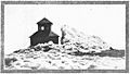
US Forest Service lookout on the summit, August 9, 1922.
-
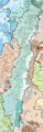
Level IV ecoregions, Cascades
-
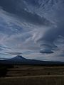
Towering lenticular clouds over Mount Adams
-
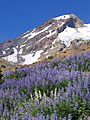
Lupine on Adams
-
Hoary marmot above the tree line on Adams
-

Gray-crowned rosy finch high up the slopes on Adams


_from_Devils_Garden.JPG)


_Map_1901_Reid.jpg)
.jpg)


.JPG)
.JPG)
.JPG)
.JPG)
See also
 In Spanish: Monte Adams para niños
