
Mount Baker facts for kids
Quick facts for kids Mount Baker |
|
|---|---|
| Kulshan or Koma Kulshan | |

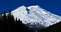
Mount Baker as seen from the Southeast at Boulder Creek
|
|
| Highest point | |
| Elevation | 10,786 ft (3,288 m) NAVD 88 |
| Prominence | 8,812 ft (2,686 m) |
| Listing |
|
| Naming | |
| Etymology | Joseph Baker |
| Native name | Error {{native name}}: an IETF language tag as parameter {{{1}}} is required (help) |
| Geography | |

Mount Baker
Location in Washington (state)
|
|
| Location | Whatcom County, Washington State, U.S. |
| Parent range | Cascade Range |
| Topo map | USGS Mount Baker |
| Geology | |
| Age of rock | Less than 140,000 years |
| Mountain type | Stratovolcano |
| Volcanic arc | Cascade Volcanic Arc |
| Last eruption | 7 September to 27 November 1880 |
| Climbing | |
| First ascent | 1868 by Edmund Coleman, John Tennant, Thomas Stratton and David Ogilvy |
| Easiest route | snow (ice) climb |

Mount Baker (Nooksack: Kweq' Smánit; Lushootseed: təqʷubəʔ), also known as Koma Kulshan or simply Kulshan, is a tall, active volcano in Washington State, United States. It stands about 10,781 ft (3,286 m) high and is covered in glaciers. Mount Baker is part of the Cascade Volcanoes mountain range.
This volcano has the second-hottest crater in the Cascade Range, after Mount St. Helens. It is located about 30 miles (48 km) east of Bellingham. Mount Baker is the newest volcano in its area. The current mountain cone is less than 140,000 years old.
Mount Baker has more glacier cover than almost any other volcano in the Cascade Range. Only Mount Rainier has more. The amount of snow and ice on Mount Baker is huge. It has more ice than all other Cascade volcanoes combined (except Rainier). It is also one of the snowiest places on Earth. In 1999, the nearby Mount Baker Ski Area set a world record. It received 1,140 in (29 m; 95 ft) of snow in one season.
Mount Baker is the third-highest mountain in Washington. It is the fifth-highest in the Cascade Range. You can see it from many places. These include Victoria and Vancouver in British Columbia. You can also see it from Seattle and Tacoma in Washington on clear days.
Indigenous peoples have known about the mountain for thousands of years. The first written record was by Spanish explorer Gonzalo Lopez de Haro. He mapped it in 1790 and called it Gran Montaña del Carmelo. Later, explorer George Vancouver named it after his officer, Joseph Baker.
Contents
Names of Mount Baker
Mount Baker has different names from the Indigenous peoples living around it.
The Nooksack live closest to the mountain's north side. They have several names for different parts of the mountain.
- Nooksack: Kweq' Smánit means "white mountain." This name refers to the whole mountain, especially the glacier-covered top above 7,000 feet.
- The open slopes between 5,000 and 7,000 feet are called Nooksack: Kwelshán. This means "shooting place," referring to hunting on the slopes.
- The sheltered meadows below 5,500 feet are known as Nooksack: Spelhpálhx̠en. This name means "many meadows."
The Upper Skagit peoples live near the mountain's south side. They call the mountain Lushootseed: təqʷubəʔ in Lushootseed. This name means "permanently snow-covered mountain."
Other Indigenous groups, like the Lummi, use names similar to the Nooksack terms. This is because they were not as close to the mountain. The Lummi name is Straits Salish: Kwelshan and the Halkomelem name is Halkomelem: Kwelxá:lxw.
The first Europeans to see the mountain were the Spanish. Gonzalo López de Haro recorded it in 1790. He called it Gran Montaña del Carmelo, which means "Great Mount Carmel."
The current English name, Mount Baker, was given by George Vancouver. He named it after his officer, Joseph Baker. Joseph Baker saw the mountain on April 30, 1792.
Mount Baker is also sometimes called "Kulshan." This is an English version of the Nooksack name Nooksack: Kwelshán. The name "Koma Kulshan" likely comes from the Nooksack phrase Nooksack: Kwóma Kwelshán. This means "go up into the mountains to Nooksack: Kwelshán."
Mountain History
.jpg)
Before Europeans arrived, the Nooksack and Upper Skagit peoples lived around Mount Baker. They hunted and gathered food on its slopes.
For the Nooksack, Mount Baker was very important in their traditional beliefs. It was also a source of valuable resources like mountain goat wool and food. Nooksack families would travel to the mountain's alpine meadows. They set up summer camps to dry berries and meat. From these camps, they would hunt deer, elk, mountain goat, and other animals.
Nooksack families mostly used the northwestern parts of the mountain. Skagit families used the southeastern half. Some other tribes could visit if they were allied with Nooksack families.
In 1790, Manuel Quimper of the Spanish Navy explored the Strait of Juan de Fuca. His pilot, Gonzalo Lopez de Haro, drew maps that included Mount Baker. The Spanish named it La Gran Montana del Carmelo.
British explorer George Vancouver arrived in 1792. His officer, Joseph Baker, saw the mountain. Vancouver wrote in his journal:
About this time a very high conspicuous craggy mountain ... presented itself, towering above the clouds: as low down as they allowed it to be visible it was covered with snow... the lofty mountain, discovered in the afternoon by the third lieutenant, and in compliment to him called by me Mount Baker, rose a very conspicuous object...

The first printed mention of Mount Baker was in 1798. By the mid-1850s, it was a well-known landmark. Isaac I. Stevens, the first governor of Washington Territory, described it in 1853. He said it was a "lofty and most conspicuous peak."
Climbing Mount Baker
First European Climbs
The first person to try climbing Mount Baker was Edmund Thomas Coleman in 1866. He was from England and had experience climbing in the Alps. His first attempt failed because local Native Americans would not let him pass.
Later that year, Coleman tried again with Edward Eldridge, John Bennett, and John Tennant. They got close to the top but had to turn back due to bad weather.
Coleman returned two years later. On August 17, 1868, Coleman, Eldridge, Tennant, and two new climbers, David Ogilvy and Thomas Stratton, reached the summit. They were the first Europeans to climb Mount Baker.
Famous Climbs
- 1948: The "North Ridge" route was climbed by Fred Beckey, Ralph, and Dick Widrig.
How Mount Baker Was Formed

Mount Baker is a relatively young volcano, perhaps less than 100,000 years old. It sits on top of an older volcano called Black Buttes. Black Buttes was active between 500,000 and 300,000 years ago.
Much of Mount Baker's older rock was worn away by glaciers during the last ice age. This ice age ended about 15,000 to 20,000 years ago. The area around the mountain has been mostly ice-free for 14,000 years. However, the mountain itself is still heavily covered with snow and ice.
Mount Baker is made of volcanic rocks. These rocks sit on top of older, non-volcanic rocks.
Mount Baker has not had many huge, explosive eruptions like Mount St. Helens. It also doesn't erupt very often. The most damaging events at Mount Baker have been lahars. Lahars are like mudslides made of volcanic ash, rock, and water. These can be caused by magma moving, steam eruptions, earthquakes, or even heavy rain.
Eruptions Through Time
Early History
Mount Baker is one of the youngest volcanoes in the Cascade Range. Volcanic activity in this area started over a million years ago. However, many of the oldest lava and ash deposits have been removed by glaciers.
Around one million years ago, a huge ash eruption caused the Kulshan caldera to collapse. Since then, eruptions have created cones and lava flows made of a rock called andesite. This is the same rock that makes up other Cascade volcanoes like Rainier and Hood.
Modern Craters

Mount Baker was built up from layers of lava and volcanic rock before the last ice age ended. There are two craters on the mountain. Carmelo Crater is under the ice at the summit. This crater was the source of the last eruptions that built the cone.
The highest point of Mount Baker, Grant Peak, is on the edge of Carmelo Crater. Carmelo Crater is cut deeply by the younger Sherman Crater. Sherman Crater is south of the summit. Its ice-covered floor is about 1,000 ft (300 m) below the summit. All recent eruptions have come from Sherman Crater.
Hundreds of vents called fumaroles release gases from the volcano. These gases are mostly water, carbon dioxide, and hydrogen sulfide. These gases turn the surrounding rock into weak, soft clays. Sulfur is often found around these fumaroles. When this weakened rock collapses, it can cause lahars. This happened in the 1840s.

Lava flowed from the summit between 30,000 and 10,000 years ago. An eruption from Sherman Crater 6,600 years ago sent ash more than 40 mi (64 km) to the east. Today, sulfurous gases come out of two fumarole areas: Dorr Fumarole and Sherman Crater.
Mazama Park Eruption: 6,600 Years Ago
Around 6,600 years ago, Mount Baker had its largest ash-producing eruption since the last ice age. This was the last time magma clearly erupted from the volcano.
First, a large collapse happened from the Roman Wall area. This turned into a lahar that was over 300 feet (91 m) deep in some places. It flowed into the Nooksack River. Then, a small steam eruption at Sherman Crater caused another collapse. This also became a lahar. Finally, an ash cloud spread ash up to 40 mi (64 km) away.
Recent Activity

Several eruptions happened from Sherman Crater in the 1800s. People in Bellingham saw them. In 1792, explorers saw "bursts of flame" from the mountain.
In 1843, explorers reported new rock fragments "like a snowfall." Rivers south of the volcano were filled with ash. Native Americans said many salmon died. Later, two lahars flowed into Baker Lake, raising its water level.
Smaller steam activity continued for decades. In 1860, people saw Mount Baker "puffing out large volumes of smoke." In 1891, a large amount of rock fell, creating a lahar that traveled over 6 mi (9.7 km).
Activity in the 1900s was less than in the 1800s. Small rock slides happened from Sherman Peak. A large one occurred on July 27, 2007.

In March 1975, there was a big increase in steam and melting snow at Sherman Crater. This made people worry that an eruption might happen soon. Heat coming from the crater increased more than ten times. Officials closed the Baker Lake recreation area and lowered the lake's water level. This was to prevent a dangerous wave if a large mudslide happened.
The activity slowly decreased over the next two years. However, it stayed higher than before 1975. The increased steam activity has continued since 1975. But there are no other signs that magma is moving inside the volcano.
Weather and Ice
Climate
Mount Baker has an alpine tundra climate. This means it is very cold and has little plant growth.
| Climate data for Mount Baker Summit. 1991-2020 | |||||||||||||
|---|---|---|---|---|---|---|---|---|---|---|---|---|---|
| Month | Jan | Feb | Mar | Apr | May | Jun | Jul | Aug | Sep | Oct | Nov | Dec | Year |
| Mean daily maximum °F (°C) | 19.3 (−7.1) |
18.6 (−7.4) |
19.1 (−7.2) |
23.2 (−4.9) |
31.7 (−0.2) |
37.7 (3.2) |
47.2 (8.4) |
47.8 (8.8) |
43.1 (6.2) |
33.2 (0.7) |
22.2 (−5.4) |
17.9 (−7.8) |
30.1 (−1.1) |
| Daily mean °F (°C) | 14.0 (−10.0) |
12.0 (−11.1) |
11.6 (−11.3) |
14.6 (−9.7) |
22.3 (−5.4) |
27.7 (−2.4) |
36.1 (2.3) |
36.8 (2.7) |
32.8 (0.4) |
24.7 (−4.1) |
16.4 (−8.7) |
12.9 (−10.6) |
21.8 (−5.7) |
| Mean daily minimum °F (°C) | 8.7 (−12.9) |
5.4 (−14.8) |
4.0 (−15.6) |
5.9 (−14.5) |
12.8 (−10.7) |
17.7 (−7.9) |
24.9 (−3.9) |
25.9 (−3.4) |
22.5 (−5.3) |
16.1 (−8.8) |
10.6 (−11.9) |
7.9 (−13.4) |
13.5 (−10.3) |
| Average precipitation inches (mm) | 27.87 (708) |
19.78 (502) |
23.14 (588) |
13.60 (345) |
9.00 (229) |
7.18 (182) |
3.65 (93) |
4.44 (113) |
10.92 (277) |
21.20 (538) |
32.47 (825) |
28.04 (712) |
201.28 (5,113) |
| Average snowfall inches (cm) | 128.5 (326) |
112.5 (286) |
136.4 (346) |
65.5 (166) |
16.0 (41) |
8.2 (21) |
0.0 (0.0) |
0.0 (0.0) |
3.0 (7.6) |
15.0 (38) |
61.5 (156) |
146.5 (372) |
693.1 (1,759.6) |
| Average dew point °F (°C) | 5.1 (−14.9) |
2.4 (−16.4) |
1.0 (−17.2) |
1.6 (−16.9) |
8.1 (−13.3) |
13.4 (−10.3) |
18.8 (−7.3) |
19.1 (−7.2) |
16.2 (−8.8) |
11.6 (−11.3) |
7.5 (−13.6) |
5.2 (−14.9) |
9.2 (−12.7) |
| Source: PRISM Climate Group | |||||||||||||
Glaciers and Water

Mount Baker has eleven named glaciers. The Coleman Glacier is the largest. It covers an area of about 1,285 acres (5.2 km2). Other large glaciers include Roosevelt Glacier, Mazama Glacier, Park Glacier, Boulder Glacier, Easton Glacier, and Deming Glacier.
All these glaciers shrank during the first half of the 1900s. They grew a little from 1950 to 1975. Since 1980, they have been shrinking faster.
Water from Mount Baker flows into several rivers. These include the North Fork and Middle Fork of the Nooksack River. Water also flows into the Baker River. Lake Shannon and Baker Lake are the biggest nearby lakes. They were formed by dams on the Baker River.
Two ammunition ships of the United States Navy have been named after Mount Baker. Navy ships are often named after volcanoes.
- The first was USS Mount Baker (AE-4). It was used from 1941 to 1947 and again from 1951 to 1969.
- In 1972, the Navy launched USS Mount Baker (AE-34). It was later used by the Military Sealift Command as USNS Mount Baker (T-AE-34). This ship was taken apart in 2012.
Images for kids
-
Mount Baker as seen from the Southeast at Boulder Creek
Error: no page names specified (help). In Spanish: Monte Baker (Estados Unidos) para niños
