Black Buttes facts for kids
Quick facts for kids Black Buttes |
|
|---|---|

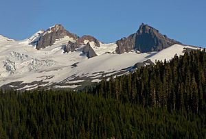
The rocky peaks of the eroded Black Buttes
|
|
| Highest point | |
| Peak | Colfax Peak |
| Elevation | 9,373 ft (2,857 m) |
| Geography | |
The Black Buttes are an extinct volcano in Washington, United States. They are also known as the Sawtooth Rocks because of their sharp, jagged shape. These rocky peaks are part of the Cascade Volcanic Arc, a chain of volcanoes.
The Black Buttes are located in Whatcom County. They are close to Mount Baker, a much younger and active volcano. The peaks of Black Buttes were shaped by glaciers over many years. Three main peaks make up the Black Buttes: Colfax, Lincoln, and Seward. All of these peaks can be climbed.
The Black Buttes volcano was active a very long time ago, between 495,000 and 288,000 years ago. Mount Baker actually sits on top of some of the lava that erupted from the Black Buttes volcano.
Contents
Exploring the Black Buttes
The Black Buttes are the remains of a huge stratovolcano that used to stand where Mount Baker is now. The Black Buttes are about 1.9 miles (3 km) from Mount Baker. They are found between Mount Baker and the middle fork of the Nooksack River.
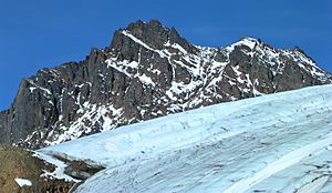
The highest point of the Black Buttes is 9,373 feet (2,857 m) tall. Its peaks are surrounded by large glaciers like the Coleman Glacier and Deming Glacier. The three main peaks are Colfax Peak (also called East Butte), Lincoln Peak (West Butte), and Seward Peak.
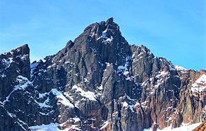
Colfax Peak
Colfax Peak, or East Butte, is the highest point of the Black Buttes. It stands 9,373 feet (2,857 m) tall. The first people to climb it were David Anderson, Clarence A. Fisher, and Paul Hugdahl in 1921.
This peak has very steep rock walls. It also has a small ice cap on its eastern side. Climbing Colfax Peak can be challenging. Some parts of the climb need special tools like ice screws.
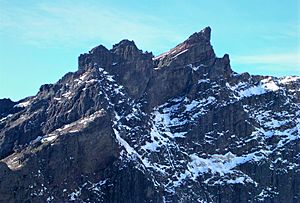
Lincoln Peak
Lincoln Peak, also known as West Butte, is about 0.7 miles (1.1 km) west of Colfax Peak. It reaches an elevation of 8,842 feet (2,695 m). This peak was first climbed on July 22, 1956. The climbing team included Fred Beckey, Wesley Grande, John Rupley, and Herb Staley.
Climbing Lincoln Peak is difficult. It takes about 9 hours and has dangers like falling rocks. The peak has a 1,000 feet (300 m) tall face on its northern side. Its eastern side has a 1,500 feet (460 m)-long face.
Seward Peak
Seward Peak is the third major peak of the Black Buttes. It is 0.7 miles (1.1 km) west of Lincoln Peak and is 7,825 feet (2,385 m) high. Dallas Kloke and Bryce Simon were the first to climb it on July 11, 1973.
Unlike the other two peaks, Seward Peak does not need a technical climb. The trip to the summit usually takes about 4 hours. Climbers follow a ridge to reach the top.
How the Black Buttes Formed
The Black Buttes are an extinct volcano. This means it is no longer active. It has a unique amphitheater shape. Its sharp peaks form a curved ridge. These shapes were created by glacial motion and erosion over thousands of years.
Today, part of the volcano's old crater is covered by the Deming Glacier. The rest of the volcano's peaks rise above the glacier.
When the Volcano Erupted
The Black Buttes volcano was active a very long time ago. Its main period of activity was between 495,000 and 288,000 years ago. During this time, it produced thick lava flows. These flows were made of a type of rock called andesite. Some lava flows were as thick as 1,950 feet (590 m).
The most active time for the volcano was between 350,000 and 330,000 years ago. Lava also erupted from vents on the sides of the volcano. These side eruptions created different types of lava. Some lava flows were formed next to ice, probably from ancient glaciers.
After the Black Buttes volcano became extinct, some other lava flows occurred nearby. These happened before Mount Baker became active.
Human History
The Black Buttes were named by Edmund T. Coleman in 1868. He was climbing Mount Baker at the time. He described the peaks as "black, jagged, splintered precipices." He also named Lincoln and Colfax Peaks.
Another historian, Charles Easton, called the Black Buttes "a homogenous mass of black basalt." He compared them to "a Chinese wall." For a time, the surveyor Thomas Gerdine called them the Sawtooth Rocks. This name was used on many early maps.
 | Percy Lavon Julian |
 | Katherine Johnson |
 | George Washington Carver |
 | Annie Easley |


