
Nooksack River facts for kids
Quick facts for kids Nooksack River |
|
|---|---|

Aerial Photo of the river in Ferndale, WA.
|
|

Nooksack Basin
|
|

Mouth of the Nooksack River in Washington
|
|
| Other name(s) | North Fork Nooksack River |
| Country | United States |
| State | Washington |
| Counties | Whatcom |
| Cities | Ferndale, Marietta |
| Physical characteristics | |
| Main source | Cascade Range Mount Baker Wilderness 3,620 ft (1,100 m) 48°50′0″N 121°33′18″W / 48.83333°N 121.55500°W |
| River mouth | Bellingham Bay 0 ft (0 m) 48°46′29″N 122°35′57″W / 48.77472°N 122.59917°W |
| Length | 75 mi (121 km) |
| Basin features | |
| Basin size | 786 sq mi (2,040 km2) |
| Tributaries |
|
The Nooksack River is a river located in western Whatcom County, in the northwestern Washington state. It flows through an area of the Cascade Range near Mount Baker, close to the border with Canada.
The river officially starts when three main smaller rivers, called tributaries, join together. These are the North Fork, Middle Fork, and South Fork. They all begin in the Mount Baker Wilderness. The North Fork is the longest and is sometimes seen as the main river. The Nooksack River is about 75 miles (121 km) long, measured from the start of the North Fork. The lower part of the Nooksack flows in a big loop through the rich farming area of the southern Fraser Lowland. It then empties into Bellingham Bay. From there, its water travels through the Strait of Juan de Fuca and the Strait of Georgia to reach the Pacific Ocean.
Contents
River's Journey
North Fork Nooksack River
The North Fork Nooksack River begins at the Nooksack Cirque in central Whatcom County. This is north of Mount Shuksan in the western part of North Cascades National Park. It collects melted water from the East Nooksack Glacier. The river generally flows west, passing north of Mount Baker. For most of its path, the North Fork runs alongside State Route 542, also known as the Mount Baker Highway.
As it flows west from the Nooksack Cirque, the river gets water from large creeks. These include Price Creek, which flows from Price Lake, and Ruth Creek. It then flows under the first highway bridge.

At Nooksack Falls, the river goes through a narrow valley. It plunges 88 feet (27 m) into a deep, rocky canyon. You can see the falls from the forest near the cliff edge. A small parking lot nearby has information about the falls and a power plant that uses the river's energy.
The North Fork continues to flow west. It receives water from several other tributaries. These include Wells Creek, which joins right at the base of the falls, and Glacier Creek, and Canyon Creek. After this, the river briefly turns south. The Middle Fork and South Fork join within a few miles of each other. The Middle Fork joins first, forming the main Nooksack River. The South Fork joins just east of Deming, within the Nooksack Indian Reservation.
The traditional name for the North Fork in the Nooksack language is Chuw7álich, which means "the next point."
Middle Fork Nooksack River
The Middle Fork Nooksack River is about 20 miles (32 km) long. It starts on the southern slopes of Mount Baker, near Baker Pass. It generally flows northwest, between Mount Baker and Twin Sisters Mountain.
The traditional name for the Middle Fork in the Nooksack language is Nuxwt’íqw’em, meaning "always-murky water."
South Fork Nooksack River
The South Fork Nooksack River is about 50 miles (80 km) long. It begins in southern Whatcom County, east of Twin Sisters Mountain, near Bell Pass and Lake Wiseman. It flows briefly south into Skagit County. Then it turns northwest and north, re-entering Whatcom County. It flows past Acme.
The traditional name for the South Fork in the Nooksack language is Nuxw7íyem, meaning "always-clear water."
The Main Nooksack River
After the Middle and South Forks join, the combined river flows northwest. It leaves the mountains and flows past the towns of Everson and Lynden. Near Everson, there is a risk of floods. The river can overflow its banks and send water into lower lands to the north, through the Sumas River and into Canada. At Lynden, the river turns southwest. Then, near Ferndale, it turns south. It enters the north side of Bellingham Bay at the Lummi Indian Reservation, about 3 miles (4.8 km) west of Bellingham.
The Nooksack River can flood because of heavy rainfall and very deep snow. Sometimes, a weather pattern called a Pineapple Express brings strong winds and rain from the central Pacific Ocean to the Northwest, causing floods. For example, one such storm flooded the city of Everson on November 7, 2006.
River Changes
The river currently provides hydroelectric power to the nearby town of Glacier. This power comes from a dam near Nooksack Falls on the North Fork. The Middle Fork also had a dam built by the City of Bellingham in the late 1950s. This dam diverted water into Lake Whatcom, which is Bellingham's drinking water supply. In July 2020, this old water diversion system was changed. The dam was removed to help restore the river channel. This change benefits important salmon spawning areas.
In the late 1800s, most of the Nooksack River's water near its mouth flowed through what is now the short Lummi River to Lummi Bay. This was northwest of Bellingham Bay. Around the early 1900s, a large log jam blocked the channel to Lummi Bay. This forced the river to change its path to the one it uses today. The new river delta that has formed is still being studied. It has created new wetlands, but it no longer supplies the old delta on Lummi Bay, except during very high water.
Images for kids
-
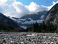
The Nooksack River cirque
-
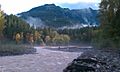
Glacier Creek joins the Nooksack River


