Strait of Georgia facts for kids
Quick facts for kids Strait of Georgia |
|
|---|---|
| French: Détroit de Géorgie | |
|
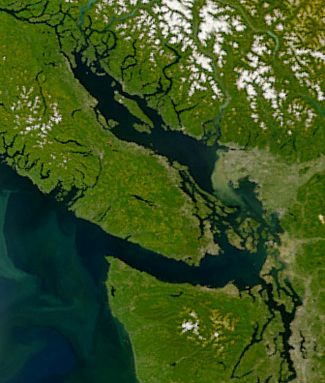
The Strait of Georgia with sediment from the Fraser River clearly visible.
|
|
| Location | British Columbia and Washington |
| Coordinates | 49°17′39″N 123°48′26″W / 49.29417°N 123.80722°W |
| Part of | Salish Sea |
| River sources | Fraser River, Squamish River |
| Ocean/sea sources | Pacific Ocean |
| Basin countries | Canada and United States |
| Surface area | 6,800 km2 (2,600 sq mi) |
| Average depth | 157 m (515 ft) |
| Max. depth | 448 m (1,470 ft) |
| Residence time | 160 days |
| Sections/sub-basins | Malaspina Strait |
| Settlements | Vancouver, Surrey, Richmond, Delta, Nanaimo, Courtenay |
The Strait of Georgia is a large arm of the Salish Sea. It lies between Vancouver Island and the mainland coast of British Columbia, Canada. It also touches the northwestern coast of Washington, United States.
This strait is about 240 kilometers (150 miles) long. Its width changes from 20 to 58 kilometers (12 to 36 miles). The Strait of Georgia is a key part of the Salish Sea. Other parts include the Strait of Juan de Fuca and Puget Sound.
At both ends of the Strait of Georgia, you'll find many islands and narrow waterways. These include the Gulf Islands and San Juan Islands in the south. In the north, you'll find the Discovery Islands. The strait is an important shipping route on the west coast of North America. This is because of the port of Vancouver and its role in the Inside Passage.
Contents
Exploring the Strait of Georgia
The Strait of Georgia is a large body of water. It has an average depth of 157 meters (515 feet). Its surface area covers about 6,800 square kilometers (2,600 square miles). The deepest part is the Ballenas Basin. It reaches a depth of 448 meters (1,470 feet) near Nanaimo.
The Fraser River is very important to the strait. It brings about 80 percent of the fresh water into the strait. The water in the strait generally moves in a counterclockwise direction.
Main Islands in the Strait
The Strait of Georgia has several large islands. The biggest is Texada Island, which is about 300 square kilometers (116 square miles). Other important islands include Nelson Island, Denman Island, Lasqueti Island, and Hornby Island.
What is the "Gulf of Georgia"?
You might hear the term "Gulf of Georgia." This term was first used by George Vancouver in 1792. It included more than just the Strait of Georgia. It covered all the inland waters past the Strait of Juan de Fuca. This meant it included Puget Sound and the waters around the San Juan Islands.
History of the Strait
First Nations people have lived around the Strait of Georgia for thousands of years. The first Europeans to explore this area were from Spain in 1791. Captain Jose Maria Narvaez and Pilot Juan Carrasco explored it. They named it "Gran Canal de Nuestra Señora del Rosario la Marinera."
In 1792, George Vancouver of Great Britain renamed it. He called it the "Gulf of Georgia" after King George III. Vancouver also named the nearby mainland "New Georgia."
A big earthquake happened on June 23, 1946. It was called the 1946 Vancouver Island earthquake. This earthquake caused the bottom of Deep Bay to sink. It dropped between 3 and 26 meters (10 and 85 feet).
The Strait of Georgia is a popular place for fun activities. People enjoy scuba diving and whale watching here. In 1967, a newspaper in Vancouver was named The Georgia Straight after the strait.
Cities and Communities
Many towns and cities are located along the Strait of Georgia. On the western side, on Vancouver Island, you'll find Campbell River, Courtenay, Comox, Qualicum Beach, Parksville, Lantzville, and Nanaimo.
On the eastern side, on the mainland, there's Powell River, Sechelt, Gibsons, and the Greater Vancouver area. Across the border in the United States, Bellingham, Washington is also on the eastern shore.
Getting Around the Strait
BC Ferries operates many ferry services across the strait. These ferries connect Vancouver Island with the mainland. Some busy routes include:
- Duke Point to Tsawwassen (south of Vancouver).
- Departure Bay to Horseshoe Bay (north of Vancouver).
- Little River to Westview.
Smaller ferry companies and water taxis also provide service to the many islands in the strait.
The Salish Sea Name
In 2008, the Chemainus First Nation suggested a new name for the strait: the "Salish Sea." This idea gained support from officials in British Columbia.
Later, a wider definition of the Salish Sea was proposed. This new name would include the Strait of Georgia, the Strait of Juan de Fuca, and Puget Sound all together. This idea was approved by geographic boards in both Canada and the United States in 2009 and 2010. The name "Salish Sea" is now used as a collective term for all these waters. It does not replace the individual names like Strait of Georgia.
Areas Facing the Strait
The Strait of Georgia is bordered by different regions in Canada and the United States.
- British Columbia, Canada
- Washington, United States
See also
 In Spanish: Estrecho de Georgia para niños
 | Selma Burke |
 | Pauline Powell Burns |
 | Frederick J. Brown |
 | Robert Blackburn |


