
BC Ferries facts for kids
|
Trade name
|
BC Ferries |
|---|---|
| Organized as a privately held company, with the provincial Crown as sole shareholder | |
| Industry | Transportation |
| Founded | Victoria, British Columbia (June 15, 1960) |
| Headquarters | Victoria, British Columbia, Canada |
|
Key people
|
Joy MacPhail, Chair Nicolas Jimenez, President & CEO |
| Products | Ferry service |
| Revenue | |
|
Operating income
|
|
| Owner | BC Ferry Authority (Government of British Columbia) |
|
Number of employees
|
4,500 (2017) |
BC Ferries is a large Canadian company that provides ferry services for people and vehicles. It helps connect coastal and island communities in British Columbia, Canada. BC Ferries started in 1960. It was created because other ferry services were having problems with strikes.
Today, BC Ferries is the biggest passenger ferry line in North America. It has 41 ships and can carry over 27,000 passengers and crew. These ferries serve 47 different places along the B.C. coast. Both the Canadian and provincial governments help fund BC Ferries. This ensures that important ferry routes are available for everyone.
Contents
How BC Ferries is Organized
When BC Ferries first started, it was part of the government. Over time, it changed its structure several times. In 2003, the government decided to make BC Ferries a private company. This was done to help it manage its money better.
Even though it's a private company, the government still owns a special share. This means the government, through the BC Ferry Authority, has a say in how BC Ferries operates.
The Story of BC Ferries
How BC Ferries Began
In 1958, a strike by workers at other ferry companies caused big problems. People couldn't travel easily between the mainland and the islands. Because of this, the government of British Columbia decided to create its own ferry service. This new service became BC Ferries, starting in 1960.


Growing the Fleet
BC Ferries' first route connected Swartz Bay on Vancouver Island to Tsawwassen near Vancouver. They started with just two ships. In the years that followed, BC Ferries grew very quickly. It took over routes from other private ferry companies.
To handle more passengers and cars, BC Ferries built many new ships. They also had a special "stretch and lift" program. This involved cutting some ships in half to make them longer. Some were even made taller to carry more vehicles. Most of BC Ferries' ships were built right in British Columbia.
For many years, BC Ferries used a special flag with a dogwood flower on a green background. This led to their popular nickname, "the Dogwood Fleet."
New Ships and Changes
In the 1990s, BC Ferries tried using three "fast ferries." These ships were meant to be quicker, but they had many problems. They also cost a lot more money than expected. Eventually, these fast ferries were sold in 2003.
Later, in 2004, BC Ferries decided to buy new ships from a shipyard in Germany. This caused some debate because many people wanted the ships to be built in B.C. However, BC Ferries said building them in Germany would save money. The first of these new ships, the Coastal Renaissance, started service in 2008.
In 2012, BC Ferries announced some changes to its schedule. They reduced the number of trips on some routes to save money. Also, free ferry trips for seniors were stopped for a few years.
More recently, BC Ferries has been adding new ships called the Salish class class. These ferries can run on natural gas, which is better for the environment. They are part of a plan to make the ferry fleet more standardized. This means having fewer different types of ships, which makes maintenance easier.
In 2022, the fourth Salish-class vessel, Salish Heron, joined the fleet.
Future Fleet Plans
BC Ferries plans to get seven new large ships to replace older ones. In 2024, they showed designs for these new vessels. They decided to build them in two stages. The first four ships were approved for purchase in March 2025.
No Canadian shipyards submitted bids to build these first ships. In June 2025, BC Ferries chose a Chinese company, CMI Weihai Shipyards, to build them. The first of these new ships is expected to start service by 2029. All four should be in use by 2031.
Financial Information
This table shows how BC Ferries has performed financially over the years. It includes money earned from tickets (Operating Revenue) and money received from the government (Service Fees and Other Govt. Subsidies).
|
Year |
Operating Revenue ($M) |
Operating Earnings ($M) |
Service Fees (Ferry Tspt.) ($M) |
Other Govt. Subsidies ($M) |
Net Regulatory Earnings ($M) |
|---|---|---|---|---|---|
| 2005 | 422 | (4) | 92 | 24 | 40 |
| 2006 | 436 | 11 | 92 | 25 | 50 |
| 2007 | 452 | 7 | 91 | 25 | 49 |
| 2008 | 481 | 8 | 104 | 26 | 37 |
| 2009 | 523 | 21 | 103 | 26 | 9 |
| 2010 | 549 | 35 | 126 | 27 | 3 |
| 2011 | 557 | 30 | 125 | 27 | 4 |
| 2012 | 555 | 25 | 127 | 27 | (16) |
| 2013 | 571 | 47 | 149 | 28 | 15 |
| 2014 | 594 | 62 | 144 | 28 | 25 |
| 2015 | 620 | 82 | 148 | 28 | 41 |
| 2016 | 673 | 99 | 144 | 29 | 65 |
| 2017 | 697 | 113 | 155 | 29 | 88 |
| 2018 | 735 | 104 | 159 | 30 | 71 |
| 2019 | 712 | 65 | 188 | 31 | 57 |
| 2020 | 707 | 33 | 198 | 31 | 22 |
| 2021 | 460 | (146) | 194 | 218 | 22 |
Current Ferry Routes
BC Ferries has many routes connecting different parts of British Columbia. Some routes carry both vehicles and passengers, while others are for passengers only. The routes are numbered for internal use by BC Ferries.
| Official routes | |||||
|---|---|---|---|---|---|
| Route Number | Route Name/Location | Highway carried | Origin | Destination(s) | Notes |
| 1 | Georgia Strait South | Highway 17 | Victoria (via Swartz Bay, on Vancouver Island) | Vancouver (via Tsawwassen) | |
| 2 | Georgia Strait Central | Highway 1 | Nanaimo (via Departure Bay, on Vancouver Island) | Vancouver (via Horseshoe Bay) | |
| 3 | Howe Sound - Mainland | Highway 101 | Vancouver (via Horseshoe Bay) | Sunshine Coast (via Langdale) | |
| 4 | Satellite Channel | Victoria (via Swartz Bay, on Vancouver Island) | Salt Spring Island (via Fulford Harbour) | ||
| 5 | Swanson Channel | Victoria (via Swartz Bay, on Vancouver Island) | Southern Gulf Islands - Galiano Island (via Sturdies Bay), Mayne Island (via Village Bay), (North) Pender Island (via Otter Bay), and Saturna Island (via Lyall Harbour) | Circle route. | |
| 6 | South Stuart Channel | Crofton (on Vancouver Island) | Salt Spring Island (via Vesuvius Bay) | ||
| 7 | Jervis Inlet - Sunshine Coast | Highway 101 | Earls Cove | Saltery Bay | |
| 8 | Queen Charlotte Channel | Vancouver (via Horseshoe Bay) | Bowen Island (via Snug Cove) | ||
| 9/9A | Active Pass Shuttle | Vancouver (via Tsawwassen) | Southern Gulf Islands - Galiano Island (via Sturdies Bay), Mayne Island (via Village Bay), (North) Pender Island (via Otter Bay), Saturna Island (via Lyall Harbour), and Salt Spring Island (via Long Harbour) | Circle route. | |
| 10 | Inside Passage | Highway 19 | Port Hardy (via Bear Cove, on Vancouver Island) | Prince Rupert (on Kaien Island) | |
| 11 | Hecate Strait | Highway 16 | Prince Rupert (on Kaien Island) | Haida Gwaii (via Skidegate, on Graham Island) | |
| 12 | Saanich Inlet - Vancouver Island | Brentwood Bay | Mill Bay | ||
| 13 | Thornbrough Channel | Sunshine Coast (via Langdale) | Gambier Island (via New Brighton) and Keats Island (via Keats Landing and Eastbourne) | Operated by Kona Winds Yacht Charters Ltd. | |
| 17 | Georgia Strait North | Comox (via Little River, on Vancouver Island) | Powell River (via Westview) | ||
| 18 | Malaspina Strait | Powell River (via Westview) | Texada Island (via Blubber Bay) | ||
| 19 | Northumberland Channel | Nanaimo (via Nanaimo Harbour, on Vancouver Island) | Gabriola Island (via Descanso Bay) | ||
| 20 | North Stuart Channel | Chemainus (on Vancouver Island) | Thetis Island (via Preedy Harbour) and Penelakut Island (via Telegraph Habour) | Triangle route. | |
| 21 | Baynes Sound | Buckley Bay (on Vancouver Island) | Denman Island (via Denman Island West) | ||
| 22 | Lambert Channel | Denman Island (via Gravelly Bay) | Hornby Island (via Shingle Spit) | ||
| 23 | Discovery Passage | Campbell River (on Vancouver Island) | Quadra Island (via Quathiaski Cove) | ||
| 24 | Sutil Channel | Quadra Island (via Heriot Bay) | Cortes Island (via Whaletown) | ||
| 25 | Broughton Strait | Port McNeill (on Vancouver Island) | Alert Bay (on Cormorant Island) and Sointula (on Malcolm Island) | Triangle route. | |
| 26 | Skidegate Inlet - Haida Gwaii | Skidegate (on Graham Island) | Alliford Bay (on Moresby Island) | ||
| 28 | Inside Passage - Central Coast Connector | Highway 19 | Port Hardy (via Bear Cove, on Vancouver Island) | Bella Coola | Year-round route. |
| 28A | Inside Passage - Central Coast Connector | Highway 19 | Port Hardy (via Bear Cove, on Vancouver Island) | Bella Coola with stops at Bella Bella (via McLoughlin Bay, on Campbell Island), Klemtu (on Swindle Island), Ocean Falls, and Shearwater (on Denny Island). | Summer-only route. |
| 30 | Mid-Island Express | Highway 19 | Nanaimo (via Duke Point, on Vancouver Island) | Vancouver (via Tsawwassen) | |
| Unnumbered | Vancouver Island East | Vancouver (via Tsawwassen) | Nanaimo (via Departure Bay, on Vancouver Island) | This route started in summer 2025 as a once-per-day, one-way service. | |
| Unregulated routes* | |||||
| Route Number | Route Location/Name | Highway carried | Origin | Destination(s) | Notes |
| 25u | Broughton Strait - Water taxi/school trip ferry | Port McNeill (on Vancouver Island) | Alert Bay (on Cormorant Island) and Sointula (on Malcolm Island) | Operated by Pacific Western Marine Ltd. | |
| 51 | Vancouver Island West | Tofino | Ahousat (on Flores Island) and Hotsprings Cove | Operated by various water taxi companies | |
| 53 | Vancouver Island Northwest | Gold River | Kyuquot and Tahsis | Operated by Get West Adventure Cruises | |
| 54 | Inside Passage | Prince Rupert (via Cow Bay, on Kaien Island) | Dodge Cove (on Digby Island) | Operated by West Coast Launch | |
| 55 | Georgia Strait North-Central | French Creek (on Vancouver Island) | Lasqueti Island (via False Bay) | Operated by Pacific Western Marine Ltd. | |
| 59 | Vancouver Island West - Barkley Sound | Port Alberni | Bamfield and Kildonan | Operated by Lady Rose Marine Services | |
| 60 | Inside Passage | Prince Rupert (on Kaien Island) | Hartley Bay, Kitkatla (on Dolphin Island), Oona River (on Porcher Island), and Metlakatla | Operated by North Co Corp. | |
| Unnumbered | Inside Passage - Tuck Inlet | Prince Rupert (on Kaien Island) | Lax Kwʼalaams (also known as Port Simpson) | Operated by the Lax-kw'alaams First Nation community | |
*These routes are run by other companies, but BC Ferries supports them.
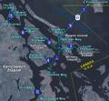
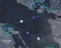
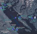
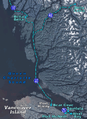
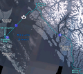
Maps of Ferry Zones
These maps show the different zones where BC Ferries operates. The numbers in blue circles are the ferry route numbers.
-
Zone 1 – Southern Gulf Islands
-
Zone 2 – Central Georgia Strait
-
Zone 3 – Northern Georgia Strait
-
Zone 4 – Queen Charlotte Sound
-
Zone 5 – North Coast


Former Ferry Routes
Over the years, some BC Ferries routes have changed or been stopped. This often happens when new roads are built, making ferry travel less necessary. For example, some routes from Kelsey Bay were discontinued when Highway 19 was extended to Port Hardy in 1978.
| Route Number | Route Location/Name | Origin | Destination(s) | Notes |
|---|---|---|---|---|
| 10 | Inside Passage | Kelsey Bay (on Vancouver Island) | Prince Rupert (on Kaien Island) | This route stopped when Highway 19 reached Port Hardy in 1978. Service then started from Bear Cove ferry terminal. |
| 40 | Inside Passage - Discovery Coast Connector | Kelsey Bay (on Vancouver Island) | Bella Coola with stops at Bella Bella (via McLoughlin Bay, on Campbell Island), Finn Bay, Hakai Pass (informal), Klemtu (on Swindle Island), Namu, Ocean Falls, and Shearwater (on Denny Island). | This route also stopped when Highway 19 reached Port Hardy in 1978. Service then started from Bear Cove ferry terminal, though some stops were removed by 1998. This route is now known as Route 28A. |
| Unknown | Inside Passage | Kelsey Bay (on Vancouver Island) | Port Hardy (via Bear Cove, on Vancouver Island) | Stopped when Highway 19 reached Port Hardy in 1978. |
| Unknown | Broughton Strait/Inside Passage | Kelsey Bay (on Vancouver Island) | Port Hardy (via Bear Cove, on Vancouver Island), Alert Bay (on Cormorant Island), and Sointula (on Malcolm Island) | Stopped when Highway 19 reached Port Hardy in 1978. Service to Alert Bay and Sointula began from the Port McNeill ferry terminal on Route 25 in 1975. |
| Unknown | Inside Passage/Vancouver Island East | Kelsey Bay (on Vancouver Island) | Vancouver (via Tsawwassen) | Stopped when Highway 19 reached Port Hardy in 1978. This route was used for special trips. |
| Unknown | Inside Passage/Vancouver Island East | Port Hardy (via Bear Cove, on Vancouver Island) | Vancouver (via Tsawwassen) | This route was used for special trips until 2000. |
The BC Ferries Fleet
BC Ferries has the largest fleet of vehicle ferries in the world! They have at least 45 ships. These range from small water taxis to huge ferries that can carry 358 cars. Most of the ferries on official routes are "roll-on/roll-off" ships. This means cars can drive right onto and off the ferry.
Many of the larger ships are part of "classes" of ferries. This means they are built using similar designs. Some of these classes include:
- Island-class ferry
- Salish-class ferry
- Spirit-class ferry
- Coastal-class ferry
- C-class ferry
- I-class ferry
- Century-class ferry
- Q-class ferry
- T-class ferry
- K-class ferry
- N-class ferry
- Unclassed ships of BC Ferries
See also
 In Spanish: B.C. Ferries para niños
Other ferry services in British Columbia
- List of inland ferries in British Columbia
- Black Ball Line
Ferry services elsewhere
- Alaska Marine Highway – Alaska's ferry system, also serves Prince Rupert.
- Inter-Island Ferry Authority
- Marine Atlantic – A ferry service on Canada's east coast.
- Washington State Ferries
- Baja Ferries - A ferry service in Mexico.
Shipyards
- Allied Shipbuilders Ltd.
- Burrard Dry Dock
- Vancouver Shipyard
- Victoria Machinery Depot
- Washington Marine Group
- Yarrow Shipbuilders
- Damen Shipyard
