Howe Sound facts for kids
Quick facts for kids Howe Sound |
|
|---|---|
| French: Baie Howe | |
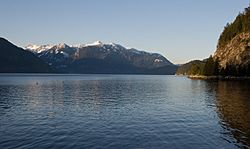
Looking up Howe Sound from Porteau Cove
|
|
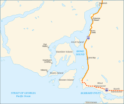
Map of Howe Sound showing Highway 99
|
|
| Coordinates | 49°30′00″N 123°19′00″W / 49.50000°N 123.31667°W |
| Type | Sound |
| Part of | Salish Sea |
| River sources | Squamish River |
| Max. length | 42 km (26 mi) |
| Islands | Anvil Island, Bowen Island, Gambier Island, Keats Island, and other minor islands |
| Settlements | West Vancouver, Squamish, Gibsons, Lions Bay, Snug Cove |
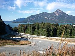
Howe Sound is a beautiful, triangle-shaped body of water in British Columbia, Canada. It's located just northwest of Vancouver. Howe Sound is actually a network of fjords, which are long, narrow inlets of the sea with steep sides, often created by glaciers.
This sound connects to the Strait of Georgia and stretches about 42 kilometers (26 miles) northeast to the town of Squamish. Many islands dot the sound, and its steep shores create strong winds, making it a great spot for sailing and wind sports.
Contents
Exploring Howe Sound's Geography
Howe Sound opens up to the southwest into the Strait of Georgia. Its entrance is between West Vancouver and the Sunshine Coast. The sound then narrows as it goes northeast towards Squamish.
The area is known for its tall, steep mountains that rise right from the water. These mountains help funnel the daily breezes. This makes the wind strong, especially at the northern end of the sound. You can also find a small volcanic rock called the Watts Point volcanic centre on the eastern shore.
A Glimpse into Howe Sound's Past
The history of Howe Sound began thousands of years ago. The Squamish and Shishalh Indigenous peoples have lived here for a very long time. They traveled these waters and used the land for their villages and camps.
Even today, the Squamish and Shishalh peoples use the land and islands for their cultural practices. Both groups are part of the larger Coast Salish cultural family.
How Howe Sound Got Its Name
In 1791, a Spanish explorer named José María Narváez saw the sound and called it Boca del Carmelo. A year later, in 1792, Captain George Vancouver explored the area. He named it Howe Sound after Admiral Earl Howe.
Mining History and Environmental Care
In 1888, copper was found in the mountains near Britannia Creek. This led to large-scale mining at Britannia Beach starting in 1905. By 1929, it was the biggest copper mine in the British Empire.
The mine closed in 1974. Over the years, the mining process released materials into Howe Sound. Today, efforts are being made to clean up the area and protect the environment. The Britannia Mine Museum now teaches visitors about the mine's history and the importance of environmental care.
Islands of Howe Sound
Howe Sound is home to many islands, each with its own unique features.
Passage Island
Passage Island is at the entrance of Howe Sound. It has a few people living there all year. From the island, you can see Downtown Vancouver and Vancouver Island.
Bowen Island
Bowen Island is the most populated island in Howe Sound. It's also the closest to Vancouver, located right across from Horseshoe Bay. Bowen Island is its own small municipality.
Gambier Island
Gambier Island is the largest island in Howe Sound. It's northwest of Bowen Island, near the Langdale ferry terminal. Gambier has a small number of year-round residents. Many more people visit in the summer months.
A foot ferry, the Stormaway IV, connects the island to the mainland. The island is great for hiking, especially in the provincial land in its northern part.
Anvil Island
Anvil Island, also known as Hat Island, is a smaller but very steep island. It's northeast of Bowen and Gambier islands. Anvil Island has a summer church camp and some seasonal homes.
Keats Island
Keats Island is near Gibsons. It has many summer homes along its shores. There's also a large church camp for kids and a retreat resort. Plumper Cove Marine Provincial Park is also on the island. A water taxi from Langdale serves the island.
Other Islands
- Pasley Group: These are privately owned islands between Keats and Bowen Islands. They have seasonal homes.
- Worlcombe Island: Located further southeast, this island is also seasonally inhabited.
- Bowyer Island: Just north of Horseshoe Bay, this steep island has seasonal homes.
- Defence Islands: These are two rocky, uninhabited islands in the northern part of Howe Sound.
- Christie Islet and Pam Rocks: South of Anvil Island, these are important bird breeding sites. You can often see seals sunning themselves here. Pam Rocks is also a weather station.
- Woolridge Island: This is a privately owned island between Gambier Island and the Port Mellon mill.
Getting Around Howe Sound
Howe Sound has important transportation routes for both people and goods.
Sea-to-Sky Highway
British Columbia Highway 99, also known as the Sea-to-Sky Highway, runs along the east shore of Howe Sound. This highway connects the Lower Mainland to towns like Lions Bay, Britannia Beach, and Squamish. From Squamish, it continues inland to Whistler. The highway was improved between 2007 and 2010.
Railways
The former British Columbia Railway (BCR) also follows the east shore, below the highway. This railway was built between 1912 and 1916. Squamish became a busy port for freight and passengers who arrived by ferry from Vancouver. Railway connections to North Vancouver were completed in the 1950s.
Ferry Services
BC Ferries provides regular ferry service in Howe Sound.
- Ferries run between Horseshoe Bay and Langdale.
- There's also a ferry between Horseshoe Bay and Snug Cove on Bowen Island.
- A foot-passenger-only ferry serves New Brighton on Gambier Island and Keats Landing and Eastbourne on Keats Island. This ferry leaves from the Langdale terminal.
- Private water taxi services are also available from Horseshoe Bay and Langdale to the islands.
Communities Along Howe Sound
Many interesting communities are located along the shores of Howe Sound.
Squamish: The Outdoor Adventure Hub
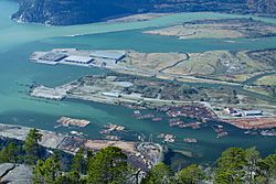
Squamish is a deepwater port at the northern end of Howe Sound. It was once a busy forestry town. Today, Squamish is a popular tourist destination. It's also a place where people live and commute to work in nearby Whistler and Vancouver.
Squamish is famous for rock climbing, thanks to the huge Stawamus Chief rock formation. The strong winds and calm waters also make it a top spot for windsurfing, kiteboarding, and sailing.
Shannon Falls and Darrell Bay
Just south of Squamish is Shannon Falls. This beautiful waterfall is a popular tourist attraction and a provincial park. Nearby, Darrell Bay is a ferry dock that used to serve the former pulp mill at Woodfibre. Woodfibre has no road access.
Porteau Cove
Porteau Cove is a provincial campsite. It's also a great spot for scuba diving. Artificial reefs have been sunk in the area, creating interesting underwater sites to explore.
Furry Creek
Furry Creek is home to a new, upscale golf course and resort. It's a scenic area along the highway.
Lions Bay
Lions Bay is a small village built on the mountainside. It climbs up from Howe Sound towards The Lions, which are two famous mountain peaks overlooking Vancouver.
Britannia Beach: A Mining Legacy
Britannia Beach is a former gold and copper mining town and port. Today, the mine site is the Britannia Mine Museum. Here, you can take mine shaft tours and even try gold panning. The large mine building has been restored and is often used for filming movies and TV shows.
Horseshoe Bay: A Ferry Gateway
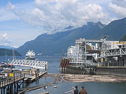
Horseshoe Bay is a busy area in West Vancouver. It's known for its BC Ferries terminal. From here, ferries go to Nanaimo on Vancouver Island, Bowen Island, and Langdale on the Sunshine Coast. The community also has restaurants, shops, and marinas.
Whytecliffe and Lighthouse Park
The peninsula southwest of Horseshoe Bay ends at Whytecliffe. This is an upscale residential area and a public park. It marks the southern point of Howe Sound's east shore. Nearby, at Point Atkinson, is Lighthouse Park, another beautiful park with great views.
Port Mellon
Just north of Langdale is Port Mellon. This is a pulp and paper mill, which is one of the oldest operating mills in British Columbia. Unlike Woodfibre, Port Mellon produces both paper and pulp.
Gibsons: Home of The Beachcombers
At the southwest "corner" of Howe Sound is the town of Gibsons. Gibsons is famous for being the setting of the old CBC Television series The Beachcombers. The restaurant from the show, Molly's Reach, is still open today.
See also
 In Spanish: Howe Sound para niños
 | Lonnie Johnson |
 | Granville Woods |
 | Lewis Howard Latimer |
 | James West |


