
José María Narváez facts for kids
Quick facts for kids
José María Narváez
|
|
|---|---|
| Born | 1768 Cádiz, Spain
|
| Died | August 4, 1840 Guadalajara, Mexico
|
| Nationality | Spanish |
| Occupation | naval officer, explorer, and navigator |
José María Narváez (1768 – August 4, 1840) was a Spanish naval officer, explorer, and navigator. He is well-known for his important work in the Gulf Islands and the Lower Mainland of what is now British Columbia, Canada. In 1791, he commanded the schooner Santa Saturnina. He led the first European journey to explore the Strait of Georgia. During this trip, he landed on the Sunshine Coast of British Columbia. He also sailed into Burrard Inlet, where the city of Vancouver is located today.
Contents
Narváez was born in Cádiz, Spain, in 1768. He joined the Royal (Naval) Academy for midshipmen in 1782. Within a year, he was already at sea, taking part in naval battles.
In 1784, Narváez was sent to New Spain (which included Mexico). His first base was in Havana. For three years, he worked on supply ships, visiting ports like Veracruz and New Orleans. In 1787, he was promoted to "qualified second pilot." A pilot in the navy is like a master, guiding the ship. He was then sent to San Blas, a major Spanish naval base on Mexico's west coast. He arrived there in early 1788. Soon after, he sailed north as a pilot for Gonzalo López de Haro on the ship San Carlos (el Filipino).
1788: Journey to Alaska
Spain began sending ships to Alaska because they heard about Russian activity there. They wanted to claim the land for Spain. Most of these efforts started from the port of San Blas. In March 1788, two ships, Princesa Real and San Carlos (el Filipino), sailed north to explore. Narváez was a pilot on the San Carlos (el Filipino). The ships reached Prince William Sound in May and soon found signs of Russian fur trading.
In June, Haro sailed the San Carlos (el Filipino) to Kodiak Island. The Spanish traded with local people who came to the ship in canoes. These people had papers with Russian writing, which Haro collected. He wanted proof of Russian business in the area.
On June 30, 1788, Haro sent Narváez in a small boat to check out a Russian post at Three Saints Bay, Kodiak Island. Narváez found the post and became the first Spaniard to meet a large group of Russians in Alaska. The Russian commander, Evstrat Delarov, visited the San Carlos (el Filipino). The Spanish gave Delarov gifts, and he gave Narváez a Russian map of the Alaskan coast. This map showed seven Russian posts and mentioned that nearly 500 men were there. Delarov also told Narváez that the Russians planned to take over Nootka Sound on Vancouver Island.
After Narváez returned, the expedition sailed to Unalaska Island, where another large Russian post was located. The Spanish leaders, including Martínez and Haro, visited the post. They exchanged gifts and maps with the Russians. The Russians confirmed their plan to occupy Nootka Sound the next year.
Martínez often had problems with his officers. While at Unalaska, he briefly arrested Haro, and Narváez took command of the San Carlos (el Filipino). Haro was soon back in charge. The ships left Unalaska on August 18, 1788. Haro, with Narváez's support, decided to sail back to San Blas on his own, arriving on October 22, 1788. Martínez arrived later and faced questions about his leadership. However, he soon regained favor and was put in charge of a new trip to Nootka Sound.
1789: Expedition to Nootka Sound
Even though Martínez and Haro had disagreements, they were ordered to sail together in 1789 to claim Nootka Sound. Narváez was again Haro's first pilot and second-in-command on the San Carlos. The ships left San Blas on February 17 and reached Nootka on May 5, 1789. Several merchant ships were already there, including one English ship and two from the United States. Martínez seized an English ship called the Northwest America.
On June 21, Martínez sent Narváez on the captured Northwest America (renamed Santa Gertrudis la Magna) to explore three inlets south of Nootka Sound. These were Clayoquot Sound, Barkley Sound, and the Strait of Juan de Fuca. Narváez sailed about 65 kilometers (40 miles) into the Strait of Juan de Fuca. Few non-native people had explored this far before him. By early July, he was back at Nootka Sound. He suggested Port Renfrew as a good place to anchor.
While Narváez was away, Martínez formally claimed Nootka for Spain. He also had conflicts with British captains, seizing their ships and crews. These events led to a big international problem. Martínez forced captured Chinese workers to build Fort San Miguel. Soon after Narváez returned, Martínez captured another English ship. This led to a sad event where the Spanish shot and killed Chief Callicum, a leader of the Nuu-chah-nulth (Nootka) people.
Martínez believed the Strait of Juan de Fuca was the entrance to the legendary Northwest Passage, a sea route through North America. On July 27, Martínez sent Haro and Narváez back to San Blas with the news. They arrived by the end of August 1789. In October, Martínez left Nootka Sound and returned to San Blas with the prisoners and captured ships.
1790: Spain Returns to Nootka
In late 1789, a new leader, Juan Vicente de Güemes Padilla Horcasitas, became the viceroy of New Spain. He and Juan Francisco de la Bodega y Quadra, the naval commander, worked hard to strengthen Spain's power in the Pacific Northwest. They sent another expedition to take back Nootka Sound. Francisco de Eliza was put in charge of the expedition and became the commander of Nootka.
Eliza's three ships left San Blas on February 3, 1790. In April, two more ships joined them. This was the largest Spanish force sent north at that time. Eliza arrived at Nootka on April 4, 1790. The Nuu-chah-nulth people had moved away because of the events from the previous summer. After taking back Fort San Miguel, Eliza sent out two exploration teams.
Salvador Fidalgo explored north to Alaska. Manuel Quimper, with López de Haro and Juan Carrasco as pilots, explored the Strait of Juan de Fuca. Both ships could not return to Nootka and instead sailed to San Blas. Eliza would not learn about their discoveries until the next year. After these ships left, Jacinto Caamaño and Narváez arrived. Narváez stayed under Eliza's command for the next two years, taking part in more explorations.
1791: Major Explorations
By early 1791, more ships and people had arrived at Nootka. Eliza received orders to explore the Strait of Juan de Fuca even more. On May 4, 1791, Eliza set out on the San Carlos. He was joined by the schooner Santa Saturnina, also called La Orcasitas. This was the same ship that John Meares had built at Nootka. Narváez commanded the Santa Saturnina, with Juan Carrasco as his pilot. The schooner was about 10 meters (33 feet) long and could be rowed. It carried about 20 days of food.

The expedition first stopped at Clayoquot Sound for about two weeks. Narváez and Carrasco spent a week exploring the inner waterways. They then worked together to create a map of the sound. While Narváez was busy, Eliza became friends with Chief Wickaninnish. Eliza wrote that he saw a dance with over 600 young men. Eliza also reported that there were five large native settlements in Clayoquot Sound, each with over 1,500 people. The largest one had over 2,500 people.
In late May, Eliza sailed the San Carlos into the Strait of Juan de Fuca to Esquimalt. The Santa Saturnina spent several weeks exploring Barkley Sound. The two ships met again at Esquimalt on June 14, 1791. In the Santa Saturnina, Narváez and Carrasco explored the inner channels of Barkley Sound and made a map. Eliza's report said Narváez saw five large settlements with "warlike and daring" people. Narváez's ship was attacked twice by groups of about 200 men, but he kept them away with cannon shots. The native people were surprised to see the schooner inside the sound, as they had never seen a ship there before.
In mid-June, Eliza's expedition was based at Esquimalt. He told Narváez, Carrasco, and others to explore Haro Strait with the Santa Saturnina and a longboat. They sailed between Vancouver Island and San Juan Island to reach Pender Island. They noticed a large opening to the east, which is now called Boundary Pass. On June 15, 1791, they sailed into "a grand and extended canal" — the open waters of the Strait of Georgia. They named it Canal de Nuestra Señora del Rosario. This was the first time Europeans had seen the Strait of Georgia. The Spaniards thought they had found a legendary inland sea that might connect to Hudson Bay or the Mississippi River. They returned to Esquimalt by June 25.
Eliza moved his base to Port Discovery on the south side of the Strait of Juan de Fuca. Eliza stayed there with the San Carlos, while Narváez and Carrasco took the Santa Saturnina and the longboat to explore Rosario Strait and the Strait of Georgia more fully.
Narváez set out on July 1, 1791. He sailed through Rosario Strait, mapping islands like Guemes Island and Cypress Island. He explored Padilla Bay and Bellingham Bay. He then headed north into the Strait of Georgia, anchoring in Birch Bay and Drayton Harbor. He sailed west across Boundary Bay and around Point Roberts.
Narváez thought Point Roberts was an island. He sailed near the mouth of the Fraser River and noticed the water was "more sweet than salt." He anchored off Point Grey, which he also thought was an island.
While anchored off Point Grey, Musqueam men visited the ship in canoes. They traded food, water, and firewood for copper and iron. The Spaniards noticed their language was different from the Nuu-chah-nulth people. The Musqueam told them the Strait of Georgia continued far north. Narváez sailed some distance into Burrard Inlet, which is now the harbor of Vancouver. His maps show the Musqueam village and other settlements.
Narváez continued north along the Sunshine Coast, anchoring at places like Sechelt and Thormanby Island. He rounded Texada Island and then crossed to the west side of Georgia Strait. He named Nanaimo Harbour Bocas de Winthuysen. He also named Porlier Pass. Narváez returned to Port Discovery on July 22, 1791.
Narváez had planned to explore Admiralty Inlet (the entrance to Puget Sound) on his way back, but he was running out of food. So, he returned directly to Eliza. The Spanish missed the chance to explore Puget Sound before the British explorer George Vancouver did the next year.
Eliza was very impressed by Narváez's report about the Strait of Georgia. Because many whales were seen in the Strait of Georgia but few in the Strait of Juan de Fuca, Eliza correctly guessed that the strait had another connection to the ocean. Eliza also suspected that Nootka Sound was on an island, not the mainland. Narváez could not explore all of the Strait of Georgia. Eliza and many of his sailors were sick, so they decided to return to Nootka. Eliza transferred Narváez to the San Carlos and gave Juan Carrasco command of the Santa Saturnina for the return trip.
Sailing west, the ships found Port Angeles on August 2, 1791. They reached Neah Bay on August 7. From there, the San Carlos, with Narváez on board, returned to Nootka Sound, arriving on November 9. Carrasco, however, sailed the Santa Saturnina south to Monterey, California, arriving there on September 16, 1791. Alessandro Malaspina, an important figure in the Spanish navy, was in Monterey. He was the first person outside Eliza's crew to learn about the discovery of the Strait of Georgia. Malaspina quickly understood how important it was to explore further. He arranged for two of his own officers to fully explore the Strait of Georgia.
Eliza, as the expedition commander, eventually received credit for most of the discoveries made during the 1791 journeys. However, Narváez was the one who commanded the ship and made the actual voyages of discovery.
Mexican War of Independence
In 1810, a rebellion started in Mexico, leading to the Mexican War of Independence. By the end of 1810, rebel forces had taken Guadalajara, the capital of Jalisco. The revolt spread to Nayarit, where the Spanish naval port of San Blas was located. A rebel army led by Father José María Mercado marched towards San Blas, which was not well defended. Many Spanish loyalists had sought safety at the naval base, hoping to escape by sea.
Narváez arrived at San Blas on November 1, 1810. He was ordered to prepare his ship, the frigate Activo, for war. The Spanish forces at San Blas were only a few hundred people, mostly Spanish merchants who had fled the rebellion. Most of the townspeople, however, supported the rebels. The rebels, numbering in the thousands, surrounded San Blas and demanded surrender. On November 30, the Spanish naval officers decided to surrender. Narváez believed their position was hopeless. The next morning, San Blas fell to the rebels.
Within a month, the revolutionaries suffered a big defeat near Guadalajara. The royalist army then took back control of San Blas. In February 1811, Narváez and other officers faced a military trial. They were accused of failing to defend San Blas. They were found guilty of treason but were cleared of most charges and allowed to return to duty. Narváez continued to serve the Spanish Navy and tried many times to clear his name.
Narváez was from Spain, so he was part of the elite group called peninsulares. But he had made Mexico his home and became more interested in the goals of the revolution. He remained loyal to the Spanish navy for a while. He even commanded a trip to the Philippines, which was under Spanish rule, in 1813-1814.
In 1815, Narváez helped blockade Mescala Island, a rebel stronghold in Lake Chapala. Royalist forces tried and failed many times to take the island. The Spanish commander then used a "scorched earth" tactic, destroying everything around the lake. In late 1816, the rebels on Mescala Island finally surrendered.
From 1817 to early 1818, Narváez mapped the province of Jalisco, including Lake Chapala. He also surveyed a new road to Guadalajara. In 1818, he was promoted for his service during the Lake Chapala campaign.
By 1818, the royalist forces had mostly calmed New Spain, and the revolutionary movement seemed to have ended. However, in 1821, a young royalist captain, Agustín de Iturbide, joined forces with rebel General Vicente Guerrero. They formed a common army and soon marched into Mexico City, declaring independence.
After Spanish rule ended, Narváez decided to stay in Guadalajara with his family. He retired from the Spanish Navy. In 1821, he was elected as Guadalajara's Provincial Deputy to the new Mexican government. When the Mexican Navy was created in late 1821, Narváez was appointed "frigate lieutenant," a higher rank than he likely would have reached in the Spanish Navy.
In 1822, Narváez was given command of the San Carlos. He sailed from San Blas to Baja California and Alta California. His mission was to set up Mexican commissions and councils in these areas. By the time he returned to San Blas in March 1823, Iturbide's government had been overthrown. A new government was set up. Narváez was appointed Commandant of the Department of San Blas. He held this position until 1827, when it was removed due to budget cuts.
In 1824 and 1825, Narváez commanded the Mexicana to survey and map the coast between San Blas and Manzanillo. In April 1825, he was promoted again. Later that year, he created maps of the border areas between Louisiana and Texas for the government. In 1826, he became a founding member of an Institute of Science, Literature, and the Arts in Mexico.
After 1827, Narváez's naval position was eliminated, but he continued to work for the Mexican Navy, making many maps. He retired in 1831 at age 63 and lived in Guadalajara on a small pension. Even in retirement, he continued to make maps, including the first official map of the state of Jalisco.
Death
Narváez died on August 4, 1840, in Guadalajara, Mexico. Historians have confirmed his birth year as 1768.
Memorials

In January 2009, the District Municipality of Sechelt in British Columbia put up a historical marker. It honors Narváez's explorations in Georgia Strait in 1791. The marker is at the south end of the Davis Bay seawall, near where he became the first European explorer to step onto the mainland coast of present-day British Columbia.
Images for kids
-
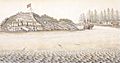
The fort of San Miguel, in San Lorenzo de Nutca.
-
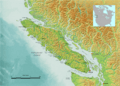
View of Vancouver Island, bordered in its southeastern part by the waters of the Strait of Juan de Fuca and the Strait of Georgia, complex waters that Narváez was the first European to explore.


See also
 In Spanish: José María Narváez para niños
