
Monterey, California facts for kids
Quick facts for kids
Monterey
|
|||
|---|---|---|---|
| City of Monterey | |||
.jpg) .jpg) .jpg) .JPG)  .jpg) Clockwise: An aerial view of Monterey; Cathedral of San Carlos Borromeo; Marina; Monterey Bay Aquarium; Naval Postgraduate School; Santa Catalina School
|
|||
|
|||
| Nickname(s):
Language Capital of the World,
California's "First" City |
|||

Location of Monterey, California
|
|||

Monterey
Location in the United States
|
|||
| Country | United States | ||
| State | California | ||
| County | Monterey | ||
| Incorporated | May 30, 1850 | ||
| Named for | Monterey Bay | ||
| Government | |||
| • Type | Council–manager | ||
| Area | |||
| • Total | 12.27 sq mi (31.77 km2) | ||
| • Land | 8.65 sq mi (22.41 km2) | ||
| • Water | 3.62 sq mi (9.37 km2) 28.03% | ||
| Elevation | 26 ft (8 m) | ||
| Population
(2020)
|
|||
| • Total | 30,218 | ||
| • Density | 2,462.8/sq mi (951.15/km2) | ||
| Time zone | UTC−8 (Pacific) | ||
| • Summer (DST) | UTC−7 (PDT) | ||
| ZIP Codes |
93940–93944
|
||
| Area code | 831 | ||
| FIPS code | 06-48872 | ||
| GNIS feature IDs | 1659762, 2411145 | ||


Monterey is a city in Monterey County, California. It sits on the southern edge of Monterey Bay along California's Central Coast. The city was founded on June 3, 1770. It was the second permanent settlement in California by the Spanish Empire, after San Diego.
Monterey was the capital of Alta California under both Spanish (1804–1821) and Mexican (1822–1846) rule. During this time, Monterey had California's first theater, public building, public library, and newspaper. It was also the only port where all taxable goods entered California. In 1846, during the Mexican–American War, the United States Flag was raised over the Customs House. After the war, California became part of the U.S. Monterey then hosted California's first meeting to create its constitution in 1849.
The city covers about 8.466 square miles (21.93 km²) of land. Its City Hall is about 26 feet (8 meters) above sea level. In 2020, the city had a population of 30,218 people.
Monterey has been a popular spot for artists and writers since the late 1800s. Many famous painters and authors have lived here. In the past, it was known for its busy fishery. Today, popular attractions include the Monterey Bay Aquarium, Cannery Row, Fisherman's Wharf, and the yearly Monterey Jazz Festival.
Exploring Monterey's Past
.jpg)
Early Inhabitants: The Ohlone People
Long before Spanish explorers arrived, the Rumsen Ohlone tribe lived in the Monterey area. They were one of seven different Ohlone groups in California. They found food by hunting, fishing, and gathering on the rich Monterey Peninsula. Scientists have found many shell middens (ancient trash piles) in the area. These show that the Ohlone people mainly ate mussels and abalone from the sea.
Spanish Arrival and Rule

Monterey is named after Monterey Bay. The bay was named Puerto de Monterrey in 1602 by Sebastián Vizcaíno. He honored the Conde de Monterrey, who was the viceroy of New Spain at the time. The Spanish did not settle Monterey Bay right away because it was too open to rough ocean currents.
In the 1700s, Spain wanted to protect its lands in California. So, they sent the Portolá expedition. In 1769, the first European land exploration of Alta California traveled north from San Diego. They were looking for Vizcaíno's "fine harbor." They did not recognize it when they arrived on October 1, 1769.
The explorers continued north to San Francisco Bay before returning. On their way back, they camped near a Monterey lagoon on November 27. Gaspar de Portolá realized he had found Vizcaíno's port. He returned by land the next year. Junípero Serra met him there by sea.
On June 3, 1770, Portolá built the Presidio of Monterey to protect the port. Serra founded the Cathedral of San Carlos Borromeo inside the presidio. Serra later moved his mission to Carmel for more independence. The original wooden and adobe church became the Royal Presidio Chapel for the soldiers.

In 1777, Monterey became the capital of the "Province of Both Californias." The chapel was renamed the Royal Presidio Chapel. The first church burned down in 1789. The current sandstone building was finished in 1794 by Indian workers. This cathedral is the oldest church in California that has been used continuously. It is also the oldest stone building in the state.
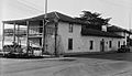
Monterey was the only port where all goods entering California by sea had to go. This happened at the Custom House. This is the oldest government building in California. The Spanish started building it in 1814. The Mexican government finished the middle part in 1827. The United States government completed the last part in 1846.
.jpg)
In 1818, an Argentine corsair (a type of pirate) named Hippolyte Bouchard attacked Monterey. His forces took the city for six days. They stole cattle and burned the fort and other Spanish buildings. The town's residents were not harmed.
Mexican Rule and Independence
Mexico became independent from Spain in 1821. But things in Alta California stayed much the same until the 1830s. Then, most mission lands became private ranchos. In 1834, the San Carlos Cemetery opened. Many early local families were buried there.
Monterey was the site of the Battle of Monterey on July 7, 1846. During the Mexican–American War, John D. Sloat of the United States Navy raised the U.S. flag over the Custom House. He claimed California for the United States.
Many "firsts" happened in Monterey. These include California's first theater, brick house, public school, public library, and printing press. The printing press printed The Californian, California's first newspaper. The Larkin House, built during the Mexican period, is an early example of Monterey Colonial architecture.
Monterey Becomes Part of the U.S.

Colton Hall, built in 1849, was first used as a public school and a government meeting place.
In 1849, Monterey hosted California's first meeting to write its constitution. This document was needed for California to become a U.S. state. Today, Colton Hall is a museum. Nearby buildings are used for local government and the Monterey post office.
Monterey became an official city in 1890.
The city was once famous for its many fish in Monterey Bay. But in the 1950s, the fishing business collapsed because too many fish were caught. Some old fishermen's cabins from the early 1900s are still on Cannery Row.
Monterey has a history as a center for California painters in the late 1800s and early 1900s. Artists like Armin Hansen and Percy Gray lived or visited to paint.
Many famous authors have also lived in and around Monterey. These include Robert Louis Stevenson, John Steinbeck, and Henry Miller.
More recently, Monterey has become known for teaching many languages. In 1995, California Governor Pete Wilson called Monterey "the Language Capital of the World."
In 2021, Apple named its macOS Monterey operating system after the Monterey region.
Monterey's Natural Environment

Monterey covers about 8.466 square miles (21.93 km²) of land and 3.62 square miles (9.37 km²) of water. The city has different areas like New Monterey and Cannery Row.
The city is in an area with some earthquake risk. The main threat is the San Andreas Fault, about 26 miles (42 km) to the east. The Monterey Bay fault is also active.
Monterey is next to the Monterey Bay National Marine Sanctuary. This is a protected ocean area that stretches for 276 miles (444 km) along the coast. This sanctuary helps protect ocean wildlife.
The California sea otter, a protected animal, lives in Monterey Bay. A rescue center for sea animals is in Monterey. The rare San Joaquin kit fox can be found in Monterey's oak forests.
Monterey has different natural habitats. These include sandy beaches, closed-cone pine forests, and Monterey Cypress trees. The pine forests have rare trees like Monterey pine and Bishop pine. The sand dunes are home to endangered plants.
Monterey's Climate and Weather
Monterey's weather is controlled by its closeness to the Pacific Ocean. This gives it a warm-summer Mediterranean climate. The city's average high temperatures range from 58.2°F (14.6°C) in December to 68.2°F (20.1°C) in September.
Most of the yearly rain, about 17.11 inches (435 mm), falls between October and April. There is very little rain in the summer. Monterey usually has 72.1 days with rain each year.
Summers in Monterey are often cool and foggy. Even summer nights are cool because of the cold ocean water. This is very different from the much hotter summers on the U.S. east coast. Monterey is at a similar latitude to Death Valley, one of the hottest places in the world, but its climate is very mild.
Snow in Monterey is very rare. It has only lightly snowed a few times, like in January 1962, February 1976, and December 1997. In March 2006, 3.2 inches (8.1 cm) of snow fell.
The lowest temperature ever recorded was 26°F (-3°C) on December 24, 1998, and January 13, 2007. On average, there are only about 1.3 days a year when the temperature reaches 90°F (32°C) or higher. There are about 1.5 days a year when the temperature drops to freezing or below.
| Climate data for Monterey, California, 1991–2020 normals, extremes 1995–2019 | |||||||||||||
|---|---|---|---|---|---|---|---|---|---|---|---|---|---|
| Month | Jan | Feb | Mar | Apr | May | Jun | Jul | Aug | Sep | Oct | Nov | Dec | Year |
| Record high °F (°C) | 80 (27) |
83 (28) |
86 (30) |
92 (33) |
97 (36) |
96 (36) |
86 (30) |
91 (33) |
101 (38) |
104 (40) |
91 (33) |
79 (26) |
104 (40) |
| Mean maximum °F (°C) | 73.4 (23.0) |
73.8 (23.2) |
76.0 (24.4) |
78.4 (25.8) |
78.7 (25.9) |
79.2 (26.2) |
77.3 (25.2) |
79.7 (26.5) |
84.7 (29.3) |
86.6 (30.3) |
79.0 (26.1) |
71.0 (21.7) |
78.15 (25.64) |
| Mean daily maximum °F (°C) | 59.3 (15.2) |
59.5 (15.3) |
60.6 (15.9) |
61.5 (16.4) |
62.9 (17.2) |
64.8 (18.2) |
65.8 (18.8) |
66.9 (19.4) |
68.2 (20.1) |
66.9 (19.4) |
62.5 (16.9) |
58.2 (14.6) |
63.1 (17.3) |
| Daily mean °F (°C) | 51.2 (10.7) |
51.9 (11.1) |
53.2 (11.8) |
54.4 (12.4) |
56.5 (13.6) |
58.6 (14.8) |
60.1 (15.6) |
60.9 (16.1) |
61.1 (16.2) |
58.8 (14.9) |
54.2 (12.3) |
50.4 (10.2) |
55.9 (13.3) |
| Mean daily minimum °F (°C) | 43.1 (6.2) |
44.4 (6.9) |
45.8 (7.7) |
47.3 (8.5) |
50.2 (10.1) |
52.4 (11.3) |
54.4 (12.4) |
54.9 (12.7) |
54.1 (12.3) |
50.8 (10.4) |
46.0 (7.8) |
42.7 (5.9) |
48.8 (9.3) |
| Mean minimum °F (°C) | 34.1 (1.2) |
37.0 (2.8) |
38.4 (3.6) |
41.0 (5.0) |
44.2 (6.8) |
47.1 (8.4) |
50.1 (10.1) |
50.2 (10.1) |
48.2 (9.0) |
43.9 (6.6) |
38.2 (3.4) |
33.6 (0.9) |
31.7 (−0.2) |
| Record low °F (°C) | 26 (−3) |
33 (1) |
35 (2) |
38 (3) |
41 (5) |
44 (7) |
47 (8) |
47 (8) |
44 (7) |
40 (4) |
33 (1) |
26 (−3) |
26 (−3) |
| Average precipitation inches (mm) | 3.45 (88) |
3.46 (88) |
2.89 (73) |
1.15 (29) |
0.50 (13) |
0.14 (3.6) |
0.02 (0.51) |
0.09 (2.3) |
0.08 (2.0) |
0.83 (21) |
1.64 (42) |
2.86 (73) |
17.11 (435) |
| Average precipitation days (≥ 0.01 in) | 10.7 | 11.6 | 10.1 | 7.0 | 3.9 | 2.1 | 1.1 | 2.0 | 1.5 | 4.2 | 7.7 | 10.2 | 72.1 |
| Source 1: NOAA | |||||||||||||
| Source 2: National Weather Service | |||||||||||||
People and Population
| Historical population | |||
|---|---|---|---|
| Census | Pop. | %± | |
| 1850 | 1,092 | — | |
| 1860 | 1,653 | 51.4% | |
| 1870 | 1,112 | −32.7% | |
| 1880 | 1,396 | 25.5% | |
| 1890 | 1,662 | 19.1% | |
| 1900 | 1,748 | 5.2% | |
| 1910 | 4,923 | 181.6% | |
| 1920 | 5,479 | 11.3% | |
| 1930 | 9,141 | 66.8% | |
| 1940 | 10,084 | 10.3% | |
| 1950 | 16,205 | 60.7% | |
| 1960 | 22,618 | 39.6% | |
| 1970 | 26,302 | 16.3% | |
| 1980 | 27,558 | 4.8% | |
| 1990 | 31,954 | 16.0% | |
| 2000 | 29,674 | −7.1% | |
| 2010 | 27,810 | −6.3% | |
| 2020 | 30,218 | 8.7% | |
| 2023 (est.) | 26,845 | −3.5% | |
| U.S. Decennial Census | |||
In 2020, the United States Census reported that Monterey had 30,218 people. There were 12,912 households. Most people (71.9%) were White. About 7.3% were Asian, and 3.7% were African American. People of Hispanic or Latino origin made up 19.0% of the population.
Monterey's Economy
Monterey has many different types of jobs. Here are some of the top employers in the city:
| Employer | Number of Employees |
|---|---|
| Community Hospital of the Monterey Peninsula | 1,000 to 4,999 |
| Ctb Mc Graw-Hill LLC | 500 to 999 |
| Dole Fresh Vegetables | 250 to 499 |
| Hyatt Regency Monterey Hotel & Spa | 250 to 499 |
| Language Line | 250 to 499 |
| Macy's | 250 to 499 |
| Monterey Bay Aquarium | 250 to 499 |
| Middlebury Institute of International Studies at Monterey | 250 to 499 |
| Monterey Plaza Hotel & Spa | 250 to 499 |
| Portola Hotel & Spa | 250 to 499 |
The top public employers are:
| Employer | Number of Employees |
|---|---|
| City of Monterey | 250 to 499 |
| Defense Language Institute | 1,000 to 4,999 |
| Monterey Peninsula College | 500 to 999 |
| Monterey-Salinas Transit | 250–499 |
| Naval Postgraduate School | 1,000 to 4,999 |
Arts and Culture in Monterey
.jpg)
Visual Arts and Museums
Monterey is home to the Monterey Museum of Art. It also has the Salvador Dalí Museum. You can find many art galleries in areas like Cannery Row and Customs House Plaza.
Literary Connections
Famous author John Steinbeck had friends in Monterey. One was Ed Ricketts, a marine biologist. Another was Bruce Ariss, an artist who designed the Wharf Theater.
After Ricketts passed away, friends would meet at his lab for jazz music. One of these friends, Jimmy Lyons, suggested holding a jazz celebration in Monterey. This idea led to the famous Monterey Jazz Festival.
In 1879, author Robert Louis Stevenson stayed in Monterey. He wrote parts of his books here. The old hotel where he stayed is now called the Stevenson House. It has items that belonged to him.
Music Festivals and History
The Monterey Jazz Festival started in 1958. It has featured famous artists like Louis Armstrong and Billie Holiday. It is known as the "longest running jazz festival in the world."
In June 1967, Monterey hosted the Monterey Pop Festival. This three-day concert was held at the Monterey County Fairgrounds. It was one of the first big rock festivals. It brought together many people, with up to 90,000 attending at its peak.
The festival was important because it was the first major U.S. appearance for Jimi Hendrix and The Who. It also featured early public performances by Janis Joplin and Otis Redding. The Monterey Pop Festival helped start the "Summer of Love" in 1967. It also became a model for future music festivals, like Woodstock.
The Monterey Blues Festival started in 1986. It ran for over 20 years. It was brought back in 2017 as the Monterey International Blues Festival.
Theater and Performances

The first paid public play in California happened in Monterey. The building is called "California's First Theater." In 1847, a sailor named Jack Swan built an adobe building. Sailors rented part of it to put on plays and make money. They earned a lot from their first show.
After the California Gold Rush in 1849, many people left, and the theater closed. In 1906, the building was bought and later given to the State of California. In 1937, a group brought back plays to the historic building. It is now permanently closed.
The Wharf Theater opened on Fisherman's Wharf in 1950. It was destroyed by fire in 1959. A new Wharf Theater, designed by Bruce Ariss, opened in 1976. It is now known as the Bruce Ariss Wharf Theater.
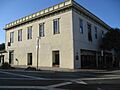
In 2005, the Golden State Theatre was renovated for live shows. This former movie theater now hosts musicals and other performances.
Popular Attractions in Monterey
Monterey is famous for its amazing marine life. You can see sea lions, sea otters, harbor seals, bat rays, and many types of whales. Just a few miles offshore is the Monterey Canyon. This is the largest and deepest underwater canyon off North America. It is about 2 miles (3.2 km) deep.
The rich marine life makes Monterey a great place for scuba divers. Scuba classes are often held at San Carlos State Beach. The Monterey Bay Aquarium on Cannery Row is one of the biggest aquariums in North America.
Monterey has many museums and over thirty historic buildings. Most are adobe buildings from the mid-1800s. Some are open to the public, like the Cooper Molera Adobe and the Robert Louis Stevenson House. The Monterey Museum of Art shows early California Impressionist paintings and photography. For younger kids, there's MY Museum, a children's museum.
You can see a unique whalebone sidewalk in front of the Old Whaling Station. It was left by whalers long ago.

Cannery Row is a historic area west of downtown Monterey. From the 1920s to the 1950s, many companies processed sardines here. The industry collapsed when too many sardines were caught.
In the late 1980s, the Monterey Bay Aquarium opened in a former cannery. The Aquarium helped make Cannery Row a popular tourist spot. It is now the most visited place on the Monterey Peninsula. It is home to over 600 types of plants and animals.
The street was renamed Cannery Row in 1953. This honored writer John Steinbeck, who wrote a famous novel with the same name. Today, it has many shops and restaurants in old cannery buildings. Some fishing companies still operate on piers nearby.

The Governor Juan Bautista Alvarado House is a California Historical Landmark. This adobe house was damaged in January 2023 during heavy floods.
Lake El Estero is a popular park in Monterey. You can go paddle boating there. It also has the Dennis the Menace Park and a skate park. Many different birds visit this park, making it popular for bird watchers.
The city also has the Monterey Sports Center for recreation.
Religious Sites
Monterey is home to the main office of the Roman Catholic Diocese of Monterey in California. The historic Catholic Carmel Mission is also nearby.
Sports in Monterey
Monterey has a professional baseball team called the Monterey Amberjacks. They play in the Pecos League. Their home games are at Sollecito Ballpark.
Monterey Bay FC is a professional soccer team. They play in the USL Championship, which is the second highest level of soccer in the U.S. They play their home games in Seaside, California.
Media and News
Local radio stations include KPIG-FM 107.5 and KAZU-FM 90.3. There are also KDON-FM 102.5, KCDU-FM 101.7, and KWAV-FM 96.9. KRML 94.7 FM plays jazz music.
Local newspapers are the Monterey County Herald and the Monterey County Weekly.
Getting Around Monterey
Transportation Options
CA 1, also called the Cabrillo Highway, runs along the coast. It connects Monterey to Monterey Bay to the north and Big Sur to the south. CA 68 connects the city to US 101 at Salinas.
Local buses are provided by Monterey-Salinas Transit.
The Monterey Regional Airport connects the city to larger cities in California and other states.
The Monterey train station had service until 1971. Then, Amtrak took over train service, and the Del Monte train stopped running.
Learning and Education


Monterey has several places for higher education. These include the Defense Language Institute, located at the Presidio of Monterey, California. The Naval Postgraduate School is on the site of an old resort hotel. The Middlebury Institute of International Studies at Monterey is a graduate school. Monterey Peninsula College is also in the city. These federal schools are important employers in Monterey.
California State University, Monterey Bay and the Monterey College of Law are in nearby Seaside. CSU Monterey Bay has programs in marine and water sciences.
The Monterey Peninsula Unified School District runs a high school, a middle school, and three elementary schools. Private schools include Santa Catalina School and Trinity Christian High School.
Famous People from Monterey
Many notable people have lived in or are from Monterey:
- Mike Aldrete, baseball player and coach
- Jean Arthur, actress
- Tory Belleci, from MythBusters
- Walter Colton, first mayor of Monterey
- Salvador Dalí, famous artist
- Doris Day, actress and singer
- Clint Eastwood, actor and director
- Joan Fontaine, Oscar-winning actress
- Richard Hamming, mathematician who influenced computer science
- Lou Henry Hoover, wife of U.S. President Herbert Hoover
- Pete Incaviglia, baseball player
- Gary Kildall, founder of Digital Research
- Sondra Locke, actress and director
- James Lofton, football player, Hall of Famer
- Jack London, author
- Michael Nesmith, member of The Monkees
- Kim Novak, actress
- Leon Panetta, former U.S. Secretary of Defense
- Ed Ricketts, marine biologist, friend of John Steinbeck
- Charles R. Schwab, businessman
- William Tecumseh Sherman, U.S. Civil War general
- John Steinbeck, Nobel Prize-winning author
- Robert Louis Stevenson, Scottish author
- Jeremy Sumpter, actor
- Edward Weston, photographer
- Frank Zappa, composer and musician
Sister Cities
Monterey is connected with these cities around the world:
- Dubrovnik, Croatia (2006)
- Isola delle Femmine, Italy (2017)
- Cervia, Italy (2014)
- Kuşadası, Turkey (2007)
- Lankaran, Azerbaijan (2011)
- Lleida, Spain (1980)
- Nanao, Japan (1995)
Images for kids
-
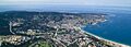
An aerial view of Monterey.
-
Santa Catalina School.
-
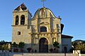
Cathedral of San Carlos Borromeo.
-
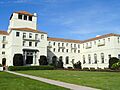
Herrmann Hall at the Naval Postgraduate School.
-
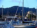
Downtown Monterey and the Harbor.
-
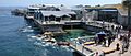
Back view of the Monterey Bay Aquarium.
-
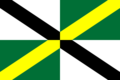
Flag of Monterey, California.
-
Seal of Monterey, California.
-
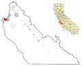
Map showing Monterey's location in Monterey County.
-
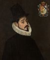
Gaspar de Zúñiga, 5th Count of Monterrey.
-
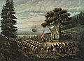
Saint Junípero Serra celebrating mass in Monterey in 1770.
-
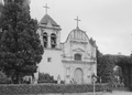
Royal Presidio Chapel around 1934.
-
The Old Custom House in 1936.
-
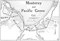
Monterey Bay area in 1917.
-

Rock sea wall near Coast Guard Station.
-

The Golden State Theatre.
-
California's First Theater.
-

Cannery Row.
-
Governor Alvarado House.
-
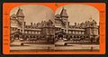
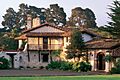
Old Del Monte Hotel.
-
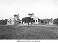
Monterey High School in 1917.
See also
 In Spanish: Monterrey (California) para niños
