
San Diego facts for kids
Quick facts for kids
San Diego
|
|||||
|---|---|---|---|---|---|
|
|||||
| Nicknames:
"America's Finest City", "Birthplace of California", "City in Motion"
|
|||||
| Motto(s):
Semper Vigilans (Latin for 'Always Vigilant')
|
|||||

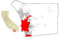
Location of San Diego in San Diego County, California
|
|||||

San Diego
Location in California

San Diego
Location in the United States

San Diego
Location in North America
|
|||||
| Country | |||||
| State | |||||
| County | |||||
| Established | July 16, 1769 | ||||
| Incorporated | March 27, 1850 | ||||
| Named for | Saint Didacus of Alcalá | ||||
| Government | |||||
| • Type | Mayor-council | ||||
| • Body | San Diego City Council | ||||
| Area | |||||
| • Total | 372.42 sq mi (964.56 km2) | ||||
| • Land | 325.88 sq mi (844.02 km2) | ||||
| • Water | 46.54 sq mi (120.54 km2) 12.68% | ||||
| Highest elevation | 1,591 ft (485 m) | ||||
| Lowest elevation | 0 ft (0 m) | ||||
| Population
(2020)
|
|||||
| • Total | 1,386,932 | ||||
| • Estimate
(2023)
|
1,388,320 | ||||
| • Rank | 20th in North America 8th in the United States 2nd in California |
||||
| • Density | 4,255.96/sq mi (1,643.25/km2) | ||||
| • Urban | 3,070,300 (US: 15th) | ||||
| • Urban density | 4,550.5/sq mi (1,756.9/km2) | ||||
| • Metro | 3,276,208 (US: 18th) | ||||
| Demonym(s) | San Diegan | ||||
| GDP | |||||
| • San Diego (MSA) | $295.6 billion (2022) | ||||
| Time zone | UTC−08:00 (PST) | ||||
| • Summer (DST) | UTC−07:00 (PDT) | ||||
| ZIP Codes |
92101–92124, 92126–92132, 92134–92140, 92142–92143, 92145, 92147, 92149–92150, 92152–92155, 92158–92161, 92163, 92165–92179, 92182, 92186–92187, 92191–92193, 92195–92199
|
||||
| Area codes | 619/858 | ||||
| FIPS code | 06-66000 | ||||
| GNIS feature IDs | 1661377, 2411782 | ||||
.jpg)
.jpg)
.jpg)
.jpg)
.jpg)
.jpg)


San Diego is a large city on the Pacific coast of Southern California. It's very close to the border with Mexico. With over 1.3 million people, it's the eighth-biggest city in the United States. It's also the second-largest city in California. San Diego is the main city of San Diego County, which has almost 3.3 million people. The city is famous for its mild weather all year, beautiful beaches, and many parks. It also has a strong connection to the United States Navy. Recently, it has become a major center for healthcare and biotechnology research.
San Diego is often called the Birthplace of California. This is because it was the first place in what is now the West Coast of the United States that Europeans visited and settled. In 1542, Juan Rodríguez Cabrillo landed in San Diego Bay and claimed the area for Spain. This led to the first European settlement in California, the Presidio and Mission San Diego de Alcalá, founded in 1769. In 1821, San Diego became part of the new Mexican Empire. California became part of the U.S. in 1848 after the Mexican–American War. It officially became the 31st state in 1850.
San Diego's economy relies on several big industries. These include military and defense, tourism, international trade, and research and manufacturing. The city has many universities, like UC San Diego and San Diego State University. San Diego is also a key part of the San Diego–Tijuana region. This is a huge area that crosses the border into Mexico. It has about five million people. The San Ysidro Port of Entry between San Diego and Tijuana is one of the busiest land border crossings in the world. San Diego International Airport is the busiest airport in the U.S. with only one runway.
Contents
What's in a Name?
San Diego got its name in the 16th century. In 1602, Spanish explorer Sebastián Vizcaíno named the bay and the area "San Diego de Alcalá". He did this to honor Saint Didacus of Alcalá.
Before the Spanish arrived, the Kumeyaay people lived here. Their town was called Kosa'aay, which means "drying out place" in their language. After the Spanish settlement, the Kumeyaay called the new town Tepacul Watai, meaning "Stacked Big".
A Look Back: San Diego's History
Early Days: Before Europeans Arrived
.jpg)
People have lived in the San Diego area for at least 9,000 years. The Kumeyaay people might have developed from these early cultures. Or, they might have moved into the area around 1000 C.E.
The Kumeyaay built villages all over the region. One important village was Kosa'aay, located where Old Town is today. Kosa'aay had 30 to 40 families living in pyramid-shaped homes. They got fresh water from a spring nearby.
Spanish Rule: First European Settlements

The first European to visit this area was explorer Juan Rodríguez Cabrillo. In 1542, he sailed his ship San Salvador from New Spain. He claimed the bay for Spain and named the spot "San Miguel." In 1602, Sebastián Vizcaíno explored the harbor. He named the area after the Catholic Saint Didacus, also known as San Diego de Alcalá.
Europeans started to settle California and San Diego permanently in 1769. Four groups of Spaniards arrived from New Spain and the Baja California peninsula. Two groups came by sea to San Diego Bay. Two other groups traveled overland from the south.

In May 1769, Gaspar de Portolà built the Presidio of San Diego. This fort was on a hill near the San Diego River. It was above the Kumeyaay village of Cosoy. This became the first European settlement in what is now California. In July of the same year, Mission San Diego de Alcalá was founded by Franciscan friars.
The mission was a place where the Kumeyaay people revolted in 1775. This forced the mission to move about 6 miles (10 km) up the San Diego River. By 1797, the mission had the largest native population in Alta California. Over 1,400 people lived there. Mission San Diego was the southern end of the historic mission trail, El Camino Real. Both the Presidio and the Mission are important National Historic Landmarks.
Mexican Rule: Independence and Changes

In 1821, Mexico became independent from Spain. San Diego then became part of the Mexican territory of Alta California. In 1822, Mexico began to take control of Alta California's coastal areas. The fort on Presidio Hill was slowly left empty. The town of San Diego grew on the flat land below the hill.
In 1834, the Mexican government took control of the Mission lands. Most of these lands were given to former soldiers. The town's 432 residents asked to form a local government. Juan María Osuna was elected the first alcalde (mayor). Beyond the town, Mexican land grants created more California ranchos. These helped the local economy.
However, San Diego's population dropped in the 1830s. This was due to growing tensions with the native Kumeyaay people. In 1838, the town lost its official status because its population fell to about 100 to 150 residents. The ranchos faced Kumeyaay raids in the late 1830s. The town itself was raided in the 1840s.

Americans learned more about California from books by traders. These books described San Diego as an important port for trade.
In 1846, the United States went to war with Mexico. They sent forces to take over Alta California. At first, it was easy. They captured major ports, including San Diego. But the Californios (Mexicans living in California) fought back. After a revolt in Los Angeles, the American soldiers in San Diego were forced out in October 1846. Mexican fighters held San Diego for three weeks. Then, on October 24, 1846, the Americans took it back.

For months, the Americans were trapped inside the town. There were daily fights and snipers shot into the town at night. The Californios tried to starve the Americans by taking their cattle. On December 1, American soldiers learned that General Stephen W. Kearney was nearby. Commodore Robert F. Stockton sent Captain Archibald Gillespie with 50 men to meet him. Their combined force of 150 men returned to San Diego. They met about 93 Californios led by Andrés Pico.
In the Battle of San Pasqual, the Americans suffered many losses. This battle happened in the San Pasqual Valley, now part of San Diego. Later, more American troops arrived and rescued Kearny's group. Stockton and Kearny then took Los Angeles. Alta California surrendered with the "Treaty of Cahuenga" on January 13, 1847. As a result of the Mexican–American War (1846–48), Alta California, including San Diego, became part of the United States. This was under the Treaty of Guadalupe Hidalgo in 1848.
American Period: Growth and Modernization

California became a U.S. state in 1850. That same year, San Diego was made the main city of the new San Diego County. It was also officially made a city. Joshua H. Bean, the last Mexican mayor, became the first American mayor. Two years later, the city went bankrupt. The state government took control until 1889. A new city charter was set up in 1889, and the current one was adopted in 1931.
The first town of San Diego was at the base of Presidio Hill. This area is now Old Town San Diego State Historic Park. But this spot was not ideal. It was several miles from the main port at La Playa. In 1850, William Heath Davis started a new area by the bay called "New San Diego." This was south of the original settlement. For many years, this new area only had a pier, a few houses, and an Army depot.
.jpg)
From 1857 to 1860, San Diego was the western end of the San Antonio-San Diego Mail Line. This was the first overland stagecoach and mail service from the Eastern U.S. to California.
In the late 1860s, Alonzo Horton encouraged people to move to the bayside area. He called it "New Town," and it became downtown San Diego. Horton promoted the area a lot. People and businesses moved there because its location on San Diego Bay was good for shipping. New Town quickly became more important than Old Town. It became the city's economic and government center. Still, San Diego remained a small town until a railroad arrived in 1878.
In 1912, San Diego had a "free speech fight." This was between the Industrial Workers of the World and the city government. The city tried to stop people from speaking freely in certain areas. This led to protests and some violence.
In 1916, the Stingaree neighborhood was torn down. This area had San Diego's first Chinatown. It was replaced by the Gaslamp Quarter.
.jpg)
In the early 1900s, San Diego hosted the World's Fair twice. The Panama–California Exposition was in 1915, and the California Pacific International Exposition was in 1935. Both were held in Balboa Park. Many of the Spanish-style buildings from these fairs are still there today. The animals from the 1915 fair helped start the San Diego Zoo.
The southern part of the Point Loma peninsula was set aside for military use in 1852. Over the next decades, the Army built coastal artillery batteries there. They named the area Fort Rosecrans. The U.S. Navy started to have a big presence in 1901. It grew a lot in the 1920s. By 1930, the city had Naval Base San Diego, Naval Training Center San Diego, and other military sites.
San Diego was also an early center for aviation. Even during World War I, it was called "The Air Capital of the West." Important airplane makers like Ryan Airlines and Consolidated Aircraft were here. Charles A. Lindbergh's famous plane, the Spirit of St. Louis, was built in San Diego in 1927.
.jpg)
During World War II, San Diego became a major center for military and defense activities. This was because of its many military bases and defense factories. The city's population grew very fast during and after the war. It more than doubled between 1930 and 1950.
After World War II, the military remained important to the local economy. But after the Cold War, defense spending was cut. This hurt the defense and aerospace industries. San Diego leaders then worked to make the city's economy more diverse. They focused on research, science, and tourism.

From the early 1900s to the 1970s, San Diego was known as "the tuna capital of the world." It had a large tuna fishing fleet and canning industry. The first tuna cannery opened in 1911. By the mid-1930s, canneries employed over 1,000 people. Many immigrant fishermen from Japan, the Azores, and Italy worked there. Their influence is still seen in neighborhoods like Little Italy. Due to rising costs, the last canneries closed in the early 1980s.
Downtown San Diego was in decline in the 1960s and 1970s. But it saw a lot of rebuilding starting in the 1980s. This included the opening of Horton Plaza and the revival of the Gaslamp Quarter. The San Diego Convention Center was also built. Petco Park opened in 2004.
As the Cold War ended, the military became smaller. San Diego then became a center for the growing biotech industry. It is also home to the telecommunications company Qualcomm. San Diego has also become a popular tourist spot. Attractions like the San Diego Zoo, SeaWorld San Diego, and Legoland California draw many visitors.
San Diego's Geography

San Diego is built on about 200 deep canyons and hills. These natural features separate its flat areas, called mesas. This creates small areas of natural open space throughout the city. People traditionally built homes and businesses on the mesas. They left the canyons mostly wild. This makes parts of the city feel divided. It also means people often need cars to get around.
The San Diego River flows through the middle of the city from east to west. This river valley divides the city into northern and southern parts. Several reservoirs and Mission Trails Regional Park also separate developed areas.

Some notable peaks within the city are Cowles Mountain, the highest point at 1,591 feet (485 m). Black Mountain is 1,558 feet (475 m) tall. Mount Soledad is 824 feet (251 m) high. The Cuyamaca Mountains and Laguna Mountains are east of the city. Beyond them are desert areas. Cleveland National Forest is only a half-hour drive from downtown San Diego. Many farms are in the valleys northeast and southeast of the city.
San Diego's Weather: A Sunny Climate
| Weather chart for San Diego | |||||||||||||||||||||||||||||||||||||||||||||||
|---|---|---|---|---|---|---|---|---|---|---|---|---|---|---|---|---|---|---|---|---|---|---|---|---|---|---|---|---|---|---|---|---|---|---|---|---|---|---|---|---|---|---|---|---|---|---|---|
| J | F | M | A | M | J | J | A | S | O | N | D | ||||||||||||||||||||||||||||||||||||
|
2
66
50
|
2.2
66
52
|
1.5
67
55
|
0.7
69
57
|
0.3
70
60
|
0.1
72
63
|
0.1
75
66
|
0
77
68
|
0.1
77
66
|
0.5
75
62
|
0.8
71
55
|
1.7
66
50
|
||||||||||||||||||||||||||||||||||||
| temperatures in °F precipitation totals in inches source: NOAA |
|||||||||||||||||||||||||||||||||||||||||||||||
|
Metric conversion
|
|||||||||||||||||||||||||||||||||||||||||||||||
San Diego has a hot-summer Mediterranean climate. This means it has warm, dry summers and mild winters. Most of the rain falls between December and March. The city enjoys mild weather all year. It has about 201 days above 70°F (21°C) and low rainfall. It gets about 9 to 13 inches (230 to 330 mm) of rain each year.
The weather in San Diego can change a lot over short distances. This is due to the city's hills, mountains, and canyons. Often, especially in May and June, a thick "marine layer" of clouds keeps the coast cool and damp. But just 5–10 miles (8–16 km) inland, it's sunny and clear. Even without the "June gloom," inland areas have bigger temperature changes than coastal areas. The ocean helps keep coastal temperatures steady.

For example, downtown San Diego has average January lows of 50°F (10°C) and August highs of 78°F (26°C). But El Cajon, only 12 miles (19 km) inland, has January lows of 42°F (6°C) and August highs of 88°F (31°C).
The average water temperature at Scripps Pier has gone up by almost 3°F (1.7°C) since 1950. Snow in the city is very rare. It has only been seen six times in the last 150 years.
| Climate data for San Diego Int'l Airport (1981–2010 normals, extremes 1874–present) | |||||||||||||
|---|---|---|---|---|---|---|---|---|---|---|---|---|---|
| Month | Jan | Feb | Mar | Apr | May | Jun | Jul | Aug | Sep | Oct | Nov | Dec | Year |
| Record high °F (°C) | 88 (31) |
90 (32) |
99 (37) |
98 (37) |
98 (37) |
101 (38) |
100 (38) |
98 (37) |
111 (44) |
107 (42) |
100 (38) |
88 (31) |
111 (44) |
| Mean maximum °F (°C) | 78.4 (25.8) |
79.2 (26.2) |
79.8 (26.6) |
82.8 (28.2) |
79.0 (26.1) |
81.2 (27.3) |
83.2 (28.4) |
85.4 (29.7) |
89.5 (31.9) |
86.8 (30.4) |
82.9 (28.3) |
76.6 (24.8) |
94.1 (34.5) |
| Mean daily maximum °F (°C) | 65.1 (18.4) |
65.0 (18.3) |
65.6 (18.7) |
67.5 (19.7) |
68.5 (20.3) |
70.8 (21.6) |
74.6 (23.7) |
76.4 (24.7) |
75.9 (24.4) |
72.8 (22.7) |
69.0 (20.6) |
64.7 (18.2) |
69.7 (20.9) |
| Mean daily minimum °F (°C) | 49.0 (9.4) |
50.7 (10.4) |
53.2 (11.8) |
55.9 (13.3) |
59.4 (15.2) |
62.0 (16.7) |
65.4 (18.6) |
66.7 (19.3) |
65.2 (18.4) |
60.6 (15.9) |
53.6 (12.0) |
48.4 (9.1) |
57.5 (14.2) |
| Mean minimum °F (°C) | 41.9 (5.5) |
44.6 (7.0) |
47.1 (8.4) |
50.7 (10.4) |
55.0 (12.8) |
59.1 (15.1) |
62.5 (16.9) |
63.3 (17.4) |
60.4 (15.8) |
54.4 (12.4) |
45.8 (7.7) |
41.4 (5.2) |
40.3 (4.6) |
| Record low °F (°C) | 25 (−4) |
34 (1) |
36 (2) |
39 (4) |
45 (7) |
50 (10) |
54 (12) |
54 (12) |
50 (10) |
43 (6) |
36 (2) |
32 (0) |
25 (−4) |
| Average rainfall inches (mm) | 1.98 (50) |
2.27 (58) |
1.81 (46) |
0.78 (20) |
0.12 (3.0) |
0.07 (1.8) |
0.03 (0.76) |
0.02 (0.51) |
0.15 (3.8) |
0.57 (14) |
1.01 (26) |
1.53 (39) |
10.34 (263) |
| Average rainy days (≥ 0.01 in) | 6.7 | 7.1 | 6.5 | 4.0 | 1.4 | 0.8 | 0.7 | 0.4 | 1.2 | 2.8 | 4.1 | 5.8 | 41.5 |
| Average relative humidity (%) | 63.1 | 65.7 | 67.3 | 67.0 | 70.6 | 74.0 | 74.6 | 74.1 | 72.7 | 69.4 | 66.3 | 63.7 | 69.0 |
| Mean monthly sunshine hours | 239.3 | 227.4 | 261.0 | 276.2 | 250.5 | 242.4 | 304.7 | 295.0 | 253.3 | 243.4 | 230.1 | 231.3 | 3,054.6 |
| Percent possible sunshine | 75 | 74 | 70 | 71 | 58 | 57 | 70 | 71 | 68 | 69 | 73 | 74 | 69 |
| Source: NOAA (sun and relative humidity 1961–1990) | |||||||||||||
Nature and Wildlife in San Diego

Like much of Southern California, San Diego was originally covered by coastal sage scrub and chaparral. These are plant communities with many drought-resistant shrubs. The varied hills and closeness to the ocean create different habitats. These include tidal marshes and canyons. The chaparral and coastal sage scrub areas near the coast often have wildfires. The number of fires increased in the 20th century. This is mainly because fires start near where cities meet wild areas.
San Diego has many large nature preserves within its city limits. These include Torrey Pines State Natural Reserve, Los Peñasquitos Canyon Preserve, and Mission Trails Regional Park. Torrey Pines State Natural Reserve is one of only two places where the rare Torrey Pine tree grows.

Many canyons within the city also serve as nature preserves. This is because their steep slopes make building difficult. Examples include Switzer Canyon, Tecolote Canyon Natural Park, and Marian Bear Memorial Park.
San Diego County has one of the highest numbers of endangered animal and plant species in the U.S. Because of its many habitats and its location on the Pacific Flyway, San Diego County has seen 492 different bird species. This is more than any other region in the country.
_(cropped).jpg)
San Diego and its surrounding areas sometimes have wildfires. In October 2003, the Cedar Fire was the largest wildfire in California in a century at that time. It burned 280,000 acres (1,100 km²). It also destroyed over 2,200 homes. The smoke from the fire caused many people to visit emergency rooms. Poor air quality made San Diego County schools close for a week. The October 2007 California wildfires also damaged some areas.
San Diego's Neighborhoods
The City of San Diego has 52 official Community Planning Areas. Each planning area can have several different neighborhoods. In total, the city has over 100 identified neighborhoods.
Downtown San Diego is located on San Diego Bay. Balboa Park is northeast of downtown. It is surrounded by older, busy communities like Hillcrest and North Park. To the east and southeast are City Heights and the College Area.
North of downtown are communities like Clairemont and Kearny Mesa. Further north are suburbs like Mira Mesa and Rancho Bernardo. The far northeast part of the city includes Lake Hodges and the San Pasqual Valley, which has farms.
Carmel Valley and Del Mar Heights are in the northwest. South of them are Torrey Pines State Natural Reserve and the business area called the Golden Triangle. Further south are the beach communities of La Jolla, Pacific Beach, and Ocean Beach. Point Loma is a peninsula across San Diego Bay from downtown.
The communities of South San Diego, like San Ysidro and Otay Mesa, are next to the Mexico–United States border. They are separated from the rest of the city by National City and Chula Vista. A narrow strip of land at the bottom of San Diego Bay connects these southern neighborhoods to the rest of the city.
- A few of San Diego's many neighborhoods.
.jpg)
_(cropped).jpg)
_(cropped).jpg)
.jpg)


.jpg)
.jpg)

.jpg)
_(cropped).jpg)
San Diego residents often understand neighborhood boundaries by natural features like canyons and street layouts. The city's 2008 General Plan focused on the idea of a "City of Villages." This plan recognized the importance of its many neighborhoods.
San Diego's Cityscape: Buildings and Views
.jpg)
San Diego first grew around the Old Town area. But by the late 1860s, people started focusing on the bayfront. They believed this new spot would bring more trade. This "New Town"—which is today's Downtown—grew quickly. It soon became the main center of San Diego, leaving Old Town behind.
The first skyscraper over 300 feet (91 m) in San Diego was the El Cortez Hotel. It was built in 1927 and was the city's tallest building until 1963. Over time, other buildings became the tallest, like the 530 B Street and Symphony Towers. Today, the tallest building in San Diego is One America Plaza. It stands 500 feet (152 m) tall and was finished in 1991.
There are no supertall buildings (very, very tall skyscrapers) downtown. This is because of a rule set by the Federal Aviation Administration (FAA) in the 1970s. This rule limits building height to 500 feet (152 m) within 1 mile (1.6 km) of San Diego International Airport. People sometimes say the downtown skyline looks like a toolbox because of its unique buildings.
Who Lives in San Diego?
| Historical population | |||
|---|---|---|---|
| Census | Pop. | %± | |
| 1850 | 500 | — | |
| 1860 | 731 | 46.2% | |
| 1870 | 2,300 | 214.6% | |
| 1880 | 2,637 | 14.7% | |
| 1890 | 16,159 | 512.8% | |
| 1900 | 17,700 | 9.5% | |
| 1910 | 39,578 | 123.6% | |
| 1920 | 74,361 | 87.9% | |
| 1930 | 147,995 | 99.0% | |
| 1940 | 203,341 | 37.4% | |
| 1950 | 334,387 | 64.4% | |
| 1960 | 573,224 | 71.4% | |
| 1970 | 696,769 | 21.6% | |
| 1980 | 875,538 | 25.7% | |
| 1990 | 1,110,549 | 26.8% | |
| 2000 | 1,223,400 | 10.2% | |
| 2010 | 1,307,402 | 6.9% | |
| 2020 | 1,386,932 | 6.1% | |
| 2023 (est.) | 1,388,320 | 6.2% | |
| Population History of Western U.S. Cities & Towns, 1850–1990 U.S. Decennial Census 2010–2020 |
|||
In 2020, San Diego had a population of 1,386,932 people. The city covers a land area of about 372.1 square miles (963.7 km²). The larger urban area of San Diego had almost 3 million people. This makes it the third-largest urban area in California.
The population grew by almost 7% from 2000 to 2010. In 2010, the city's population was 1,307,402. The population density was about 3,772 people per square mile (1,456 per km²).
San Diego is a very diverse city. In 2010, 58.9% of residents were White. 6.7% were African American, and 15.9% were Asian. People of Hispanic or Latino background made up 28.8% of the population. Most of them (24.9%) were of Mexican heritage.
.png)
In 2000, 24.0% of San Diego residents were under 18 years old. 10.5% were 65 or older. In 2011, the average age was 35.6 years. More than a quarter of residents were under 20.
In 2000, the average income for a household in the city was $45,733. For a family, it was $53,060. In 2005, Forbes magazine said San Diego was the fifth wealthiest U.S. city. However, about 14.6% of the population lived below the poverty line. This included 20.0% of those under 18. By 2008, the average household income had risen to $66,715.
San Diego is known for being friendly to LGBT people. In 2013, it was named the ninth-most LGBT-friendly city in the U.S. San Diego State University was also named one of the top LGBT-friendly campuses.
Religious Beliefs in San Diego
A 2014 study found that 68% of San Diego residents identify as Christians. This includes 32% who are Protestant and 32% who are Roman Catholic. About 27% of people said they had no religious affiliation. Other religions, like Judaism, Buddhism, Islam, and Hinduism, made up about 5% of the population.
People from Other Countries
Most of San Diego's foreign-born residents come from Mexico, the Philippines, China, and Vietnam.
San Diego's Economy


San Diego's economy is mainly driven by four big areas: defense/military, tourism, international trade, and research/manufacturing. In 2018, the average household income in San Diego was $79,646. The average home value was $654,700. Most homes have two cars.
Top Employers in San Diego
Here are the largest employers in San Diego, based on a 2024 report:
| Employer | No. of Employees |
|---|---|
| Naval Base San Diego | 40,472 |
| University of California, San Diego | 39,688 |
| Sharp HealthCare | 20,139 |
| County of San Diego | 18,936 |
| San Diego Unified School District | 17,226 |
| Scripps Health | 14,732 |
| City of San Diego | 13,408 |
| Qualcomm | 10,124 |
| Kaiser Permanente | 7,687 |
| Northrop Grumman | 6,639 |
Defense and Military in San Diego
_(cropped).jpg)
San Diego's economy is greatly helped by its deepwater port. This port has the only major submarine and shipbuilding yards on the West Coast. Many big national defense contractor companies started and are based in San Diego. These include General Atomics and NASSCO.
San Diego hosts the largest naval fleet in the world. In 2008, it had 53 ships and over 35,000 sailors and marines. About 5% of all civilian jobs in the county are related to the military. 15,000 businesses in San Diego County rely on contracts from the Department of Defense.
.jpg)
Military bases in San Diego include facilities for the US Navy, Marine Corps, and Coast Guard. The city is home to most of the U.S. Pacific Fleet's ships. The military presence in San Diego continues to grow. As of 2020, it provides about 25% of the city's total economic output. It also provides 23% of all jobs in San Diego.
Tourism in San Diego
.jpg)
Tourism is a huge industry in San Diego. This is thanks to the city's great weather, beaches, and fun attractions. Popular spots include Balboa Park, Belmont Park, the San Diego Zoo, and SeaWorld San Diego.
San Diego's Spanish and Mexican history can be seen in many old sites. These include Mission San Diego de Alcalá and Old Town San Diego State Historic Park. The local craft brewing industry also brings many visitors. San Diego is even called "America's Craft Beer Capital."
In 2012, San Diego County welcomed over 32 million visitors. They spent an estimated $8 billion. The tourism industry provides jobs for more than 160,000 people.
San Diego used to have the second-largest cruise ship industry in California. Many cruise lines operate from San Diego. However, cruise ship business has decreased since 2008.
Local boat tours are offered in San Diego Bay and Mission Bay. You can also go on whale-watching cruises to see gray whales. Sport fishing is another popular activity. San Diego has Southern California's largest sport fishing fleet.
International Trade in San Diego
.jpg)
San Diego's commercial port and its location near the United States–Mexico border make international trade very important. The city is allowed by the U.S. government to be a foreign-trade zone. This means special rules apply to goods coming in and out.
The city shares a 15-mile (24 km) border with Mexico. This border has two crossing points. The San Ysidro Land Port of Entry in the San Ysidro neighborhood is the busiest international land border crossing in the world. A second, mainly commercial, crossing is in the Otay Mesa area. It handles the third-highest amount of trucks and trade value among all U.S.-Mexico land crossings.
_(cropped).jpg)
The Port of San Diego is the third-busiest port in California. It is also one of the busiest on the West Coast. One of its two cargo facilities is in downtown San Diego. This terminal can handle many types of goods for import and export. In 2009, the Port of San Diego handled over 1.1 million short tons of trade.
Historically, tuna fishing and canning were major industries in San Diego. Although the American tuna fishing fleet is no longer based here, seafood company Bumble Bee Foods is still headquartered in San Diego.
Major Companies in San Diego

San Diego is home to several big companies that make wireless cellular technology. Qualcomm was founded and is based in San Diego. It is one of the largest private employers in the city. Other wireless companies like Nokia and LG Electronics also have offices here. San Diego is also the U.S. headquarters for the security company ESET.
University of California, San Diego and other research centers have helped the biotechnology industry grow. In 2013, San Diego had the second-largest biotech industry in the United States. There are over 400 biotechnology companies in the area. The La Jolla and Sorrento Valley areas have many biotech company offices and research labs. Big biotech companies like Illumina are based in San Diego. Many other biotech and pharmaceutical companies also have facilities here.
Real Estate in San Diego
.jpg)
San Diego has very high real estate prices. Home prices reached their highest point in 2005. Then they dropped, following a national trend. By December 2010, prices were down 36% from their peak. The average home price had dropped by over $200,000. As of May 2015, the average house price was $520,000. In November 2018, it was $558,000.
In 2009, the San Diego area was one of the least affordable places to buy a home in the U.S. As of 2023, most homes (nearly 60%) in San Diego are listed for over $1 million. The city's average home price is $910,000. This makes it the fourth most expensive among the 30 largest U.S. cities.
Because of high housing costs, many people have moved out of San Diego since 2004. A lot of people have moved to nearby Riverside County. They then commute daily to jobs in San Diego. Others are leaving the area completely for more affordable places.
Learning in San Diego
Schools for Kids and Teens
.jpg)
Public schools in San Diego are run by different school districts. Most of the city's public schools are part of the San Diego Unified School District. This is the second-largest school district in California. It includes many elementary, middle, and high schools. It also has many charter schools.
Some schools within the city are served by other school districts. These districts are based outside the city limits. There are also many private schools in San Diego.
Colleges and Universities in San Diego
.jpg)
San Diego has a highly educated population. In 2017, 44.4% of San Diegans aged 25 and older had a bachelor's degree. This is much higher than the national average of 30.9%. The U.S. Census Bureau ranks San Diego as the ninth-most educated city in the United States.
The biggest university in the area is the University of California, San Diego (UC San Diego). It is the southernmost campus of the University of California system. It is also the second-largest employer in the city. UC San Diego is known for its very high research activity. It has the 7th largest research spending in the country.
Other public colleges and universities include San Diego State University (SDSU). The San Diego Community College District has three colleges: San Diego City College, San Diego Mesa College, and San Diego Miramar College.
.jpg)
Private non-profit universities include the University of San Diego (USD) and Point Loma Nazarene University (PLNU). There are also campuses for National University and University of Redlands.
San Diego has one medical school, the UC San Diego School of Medicine. There are also three law schools that are approved by the American Bar Association. These are California Western School of Law, Thomas Jefferson School of Law, and University of San Diego School of Law.
Libraries in San Diego

The city's public library system is called the San Diego Public Library. Its main office is downtown. It has 36 branches all over the city. The newest library opened in Skyline Hills in 2015. The libraries have had shorter hours since 2003 due to city budget issues. But in 2006, the city increased library spending. A new nine-story Central Library opened downtown in 2013.
Besides the public library, there are almost two dozen other libraries open to the public. These are run by other government groups, schools, and universities. Important ones include Malcolm A. Love Library at San Diego State University and Geisel Library at the University of California, San Diego.
San Diego's Culture
.jpg)
San Diego's culture is a mix of American and Mexican cultures. This is because it's right on the Mexico–United States border. It also has a large Chicano population and a history as part of Mexico. San Diego's long connection with the U.S. military also shapes its culture.
Many popular museums are in Balboa Park. These include the San Diego Museum of Art, the San Diego Natural History Museum, the Museum of Us, and the San Diego Air & Space Museum. Balboa Park is also home to the San Diego Zoo. The Museum of Contemporary Art San Diego (MCASD) has locations in La Jolla and downtown.

The Columbia district downtown has historic ships. These belong to the Maritime Museum of San Diego. The most famous is the Star of India. There's also the USS Midway Museum, which is on an aircraft carrier.
The San Diego Symphony performs regularly at Symphony Towers. The San Diego Opera performs at Civic Center Plaza. The Old Globe Theatre in Balboa Park puts on about 15 plays and musicals each year. The La Jolla Playhouse at UC San Diego also produces many shows. Both the Old Globe Theatre and La Jolla Playhouse have premiered plays and musicals that later won Tony Awards on Broadway.
The Joan B. Kroc Theatre at Kroc Center's Performing Arts Center is a modern theater. It has 600 seats and hosts music, dance, and theater shows. Hundreds of movies and many TV shows have been filmed in San Diego. This tradition goes back to 1898.
Sports in San Diego

San Diego has teams in major professional sports leagues. It also has other high-level professional teams and minor league teams. College sports are popular too. San Diego has two major professional teams: the San Diego Padres in Major League Baseball (MLB) and San Diego FC in Major League Soccer (MLS).
The city is home to several universities with NCAA Division I sports teams. The San Diego State Aztecs are especially well-known. The Farmers Insurance Open, a professional golf tournament, is held every year at Torrey Pines Golf Course.
San Diego used to have the National Football League (NFL)'s San Diego Chargers from 1961 to 2017. That team then moved to Los Angeles. The city also had the National Basketball Association (NBA)'s San Diego Rockets (1967–1971) and San Diego Clippers (1978–1984). San Diego has never had a National Hockey League (NHL) team.
Currently, there is no NFL, NBA, or NHL team in San Diego. San Diego is the largest American city that has not won a championship in a "Big Four" major professional league. However, the city does have one major league title. The San Diego Chargers won the 1963 American Football League (AFL) Championship. Some San Diego sports fans even believe there is a curse on professional sports in the city.
Media in San Diego
The main daily newspaper in San Diego is The San Diego Union-Tribune. There are also free weekly newspapers like San Diego CityBeat and the San Diego Reader. The Times of San Diego is a free online newspaper. Voice of San Diego is a non-profit online news source. It covers local government, politics, education, and arts.
San Diego was a leader in broadband internet use in 2004.
San Diego's first TV station, KFMB, started broadcasting in 1949. Because Los Angeles had many TV channels, San Diego had fewer options at first. But in 1952, new types of channels became available. Stations from Mexico also serve the San Diego area.

San Diego is the largest U.S. media market that cannot have two full-power TV stations owned by the same company. This is due to rules from the Federal Communications Commission (FCC).
San Diego has many radio stations. These include big broadcasters like iHeartMedia and local stations. You can find news, talk, and music stations. There are also several Spanish-language radio stations.
City Infrastructure
Getting Around San Diego: Transportation
.jpg)
Most San Diego residents (over 80%) use cars to get around. The city has a large network of freeways and highways. These include Interstate 5, which goes south to Tijuana and north to Los Angeles. Interstate 8 goes east to Arizona. Interstate 15 goes northeast to Las Vegas. Interstate 805 splits from I-5 near the Mexican border.
Major state highways connect different parts of the city. For example, SR 94 connects downtown to eastern areas. SR 163 connects downtown to the northeast. The part of SR 163 that goes through Balboa Park is San Diego's oldest freeway. It opened in 1948 and is known as one of America's most beautiful parkways.
.jpg)
San Diego's road system also has many bike routes. The dry, mild weather makes cycling a good option all year. However, the city's hills and long distances make it less practical for daily commutes. Most cycling is for fun.
San Diego has a light rail system called the San Diego Trolley. It also has the MTS bus system and a bus rapid transit system called Rapid. Commuter trains like the Coaster and Pacific Surfliner also serve the area. The trolley mainly serves downtown and nearby communities. A new trolley extension opened in November 2021. It connects Old Town to University City and University of California, San Diego.

Amtrak and Coaster trains run along the coast. They connect San Diego with Los Angeles and other cities. There are two Amtrak stations in San Diego: in Old Town and Santa Fe Depot downtown. You can find public transportation information online or by dialing "511".
_Terminal_2_(upper_deck)_-_August_2018.jpg)
The city has two major commercial airports. San Diego International Airport (SAN) is the busiest airport in the U.S. with only one runway. It served over 24 million passengers in 2018. Tijuana International Airport has a terminal within San Diego's city limits. It connects to the rest of the airport in Tijuana, Mexico, via a footbridge called the Cross Border Xpress. The city also has two smaller airports for general aviation.

Recent transportation projects aim to reduce traffic. These include improving freeways and expanding San Diego Airport. The cruise ship terminal capacity has also been doubled. Freeway projects include expanding Interstates 5 and 805. A toll road (SR 125) connects to the Mexican border. In 2007, only 37% of city streets were in good condition. However, the budget was not enough to fix all of them.
City Services: Utilities
The Water Department of the City of San Diego provides water to residents. Most of the city's water comes from the Metropolitan Water District of Southern California. This water comes from the Sacramento and San Joaquin rivers and the Colorado River.
San Diego Gas & Electric provides gas and electricity. This company serves 3.7 million people in San Diego and southern Orange counties.
Street Lights
.JPG)
In the mid-1900s, San Diego used mercury vapor street lamps. In 1978, the city decided to switch to more efficient sodium vapor lamps. This caused concern for astronomers at Palomar Observatory, about 60 miles (97 km) north of the city. They worried the new lights would create too much light pollution and make it harder to observe stars. The city changed its lighting rules to limit light pollution within 30 miles (48 km) of Palomar.
In 2011, the city planned to upgrade 80% of its street lights. They would use new energy-efficient lights that produce a broader light spectrum. This new system is expected to save $2.2 million per year in energy and maintenance. In 2014, San Diego announced plans to be the first U.S. city to install smart, cyber-controlled street lighting.
Famous People from San Diego
Sister Cities
San Diego has "sister cities" around the world. These are cities that have special friendly relationships.
 Alcalá de Henares, Spain (since 1982)
 Campinas, Brazil (since 1995)
 Cavite City, Philippines (since 1969)
 Edinburgh, Scotland (since 1977)
 Jalalabad, Afghanistan (since 2004)
 Jeonju, South Korea (since 1983)
 León, Mexico (since 1969)
 Panama City, Panama (since 2015)
 Perth, Australia (since 1986)
 Taichung, Taiwan (since 1983)
 Tema, Ghana (since 1976)
- Tijuana, Mexico (since 1993)
 Vladivostok, Russia (since 1991)
 Warsaw, Poland (since 1996)
 Yantai, China (since 1985)
 Yokohama, Japan (since 1957)
Images for kids
-

The official flag of San Diego.
-
The official seal of San Diego.
-
A map showing San Diego's location in San Diego County.
See also
 In Spanish: San Diego (California) para niños
