Transportation in San Diego facts for kids
Transportation in San Diego has many ways to get around! You can travel by air, road, sea, and public transportation like buses and trains.
Contents
Public Transportation in San Diego
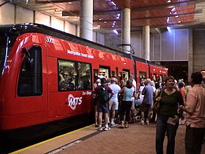
San Diego has a great public transportation system. It includes the San Diego Trolley, buses (run by the San Diego Metropolitan Transit System), the COASTER train, and Amtrak trains.
The trolley mostly serves downtown San Diego and nearby areas. It also goes to Mission Valley, the eastern part of the county, the coastal south bay, and the border with Mexico. There are plans to add new trolley lines, like one from Old Town to University City.
The Amtrak and COASTER trains run along the coast. They connect San Diego with cities like Los Angeles, Orange County, and Riverside. You can find two Amtrak stations in San Diego: one in Old Town and another downtown at the Santa Fe Depot.
Buses are available on most major roads, especially in central San Diego. You might wait 15 to 60 minutes for a bus, depending on where you are. Trolleys usually arrive every 7 to 30 minutes. You can also take a ferry across San Diego Bay to Coronado every half hour.
How People Use Public Transportation
On a weekday, people in San Diego often spend about 70 minutes traveling on public transportation. About 23% of these riders travel for more than two hours each day. People usually wait about 16 minutes at a bus stop or train station. About 29% of riders wait for over 20 minutes. The average distance people travel on one public transit trip is about 11.2 kilometers (about 7 miles).
Cycling in San Diego
San Diego's sunny and mild weather makes cycling a fun way to get around all year. The city has over 1,570 miles of bike paths and lanes. Some of these are special bike-only paths, especially in newer areas. Most bike lanes are painted on regular roads.
Because San Diego has many hills and canyons, and places are spread out, cycling for daily errands can be a bit challenging. In 2014, about 0.9% of people rode bikes to work. This was a little less than the average for big U.S. cities.
A bike-sharing program called Decobike started in 2015. This lets you rent bikes for short trips.
Air Travel in San Diego
San Diego has two main international airports.
San Diego International Airport, also known as Lindbergh Field, is the city's main airport. It is the busiest airport in the world with only one runway! More than 24 million passengers use it every year. The airport is located right on San Diego Bay, about 3 miles (4.8 km) from downtown. You can fly from here to many places in the United States, Canada, Japan, Mexico, the United Kingdom, Germany, and Switzerland.
Since 2015, the Cross Border Xpress terminal in Otay Mesa has offered a unique way to reach Tijuana International Airport in Mexico. Passengers can walk across the U.S.–Mexico border on a special bridge to catch their flights on the Mexican side. It's the only airport in the world with terminals in two different countries!
Other airports in San Diego include Brown Field Municipal Airport and Montgomery Field.
Sea Travel and Shipping
The Port of San Diego manages all the ship activities in San Diego harbor. If you want to go on a cruise, ships leave from the B Street Pier and the Broadway Pier. Big cruise lines like Carnival and Holland America have ships based here during the winter.
San Diego is also home to General Dynamics' National Steel and Shipbuilding Company (NASSCO). This is the largest shipyard on the West Coast of the United States. They can build and fix very large ships. NASSCO builds cargo ships and support vessels for the U.S. Navy.
Roads and Highways
The streets and highways of San Diego are very important for getting around. San Diego grew a lot, and many freeways were built to help people travel from the suburbs into the city. Tourism is also a big part of San Diego, and about 70% of visitors arrive by car.
Major Highways
San Diego is where three main interstate highways begin or end. There is also one important bypass interstate.
| Interstate 5 San Diego Freeway |
Interstate 5 starts at the U.S.-Mexico border. It goes north through downtown San Diego and along the coast, continuing up to Los Angeles. | |
| Interstate 8 Ocean Beach Freeway Kumeyaay Highway |
Interstate 8 begins in Ocean Beach. It heads east through Mission Valley and San Diego's eastern suburbs, then continues into Arizona. | |
| Interstate 15 Escondido Freeway |
Interstate 15 starts at I-8 in Mission Valley. It goes northeast through the city's inland suburbs and then continues to Las Vegas, Nevada. | |
| Interstate 805 Jacob Dekema Freeway |
Interstate 805 is a bypass road for Interstate 5. It starts near the Mexican border in San Ysidro and rejoins I-5 near Del Mar. |
California State Routes
Here are some important state highways in San Diego:
| State Route 11 |
SR 11 is a short freeway in Otay Mesa. It will eventually extend east as a toll road to the Otay Mesa East Port of Entry at the border. | |
| State Route 15 Escondido Freeway |
SR 15 is a continuation of I-15. It runs south from the I-8/I-15 interchange to I-5 in Southeast San Diego near the 32nd Street Naval Station. | |
| State Route 52 San Clemente Canyon Freeway Mount Soledad Freeway |
SR 52 connects La Jolla with East County through Santee and SR 125. | |
| State Route 54 South Bay Freeway Jamacha Boulevard |
SR 54 starts at I-5 in National City. It travels northeast to SR 125 near Spring Valley, then continues on Jamacha Road to El Cajon. | |
| State Route 56 Ted Williams Freeway |
SR 56 connects I-5 with I-15. It goes through Carmel Valley and Rancho Peñasquitos. | |
| State Route 67 San Vicente Freeway |
SR 67 runs north from I-8 and El Cajon towards Lakeside. It then becomes a smaller road and continues north towards Ramona. | |
| State Route 75 San Diego-Coronado Bridge Silver Strand Boulevard Palm Avenue |
SR 75 crosses San Diego Bay on the San Diego-Coronado Bridge. It then goes south along the Silver Strand from Coronado to South San Diego, where it becomes Palm Avenue. | |
| State Route 78 San Pasqual Valley Road |
SR 78 is within San Diego city limits from San Pasqual Road to Guejito Truck Trail. It continues west to Escondido and Oceanside. Eastward, it goes towards Brawley and up to I-10. | |
| State Route 94 Martin Luther King Jr. Freeway Campo Road |
SR 94 connects downtown with I-805, SR 15, and East County. | |
| State Route 125 South Bay Expressway |
SR 125 connects East County cities from SR 905 near the Otay Mesa Port of Entry north to Santee. Part of SR 125 is a toll road called the South Bay Expressway. | |
| State Route 163 Cabrillo Freeway Dean E. Beattie Memorial Highway |
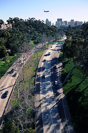
SR 163 connects downtown with the northeast part of the city. It crosses I-805 and joins I-15 at Miramar. The part of SR 163 that goes through Balboa Park is San Diego's oldest freeway and is known for being very beautiful. | |
| State Route 905 Otay Mesa Freeway |
SR 905 connects I-5 and I-805 to the Otay Mesa Port of Entry at the border. |
Major Streets
- Rosecrans Street
- Balboa Avenue
- El Cajon Boulevard
 | Bayard Rustin |
 | Jeannette Carter |
 | Jeremiah A. Brown |


