
Mexico–United States border facts for kids
Quick facts for kids Mexico–United States border |
|
|---|---|
| Characteristics | |
| Entities | |
| Length | 3,145 kilometers (1,954 mi) |
| History | |
| Current shape | April 18, 1972 Boundary Treaty of 1970 |
| Treaties | Adams–Onís Treaty, Treaty of Limits, Treaty of Guadalupe Hidalgo, Gadsden Purchase |


The Mexico–United States border is a long line that separates Mexico and the United States. It stretches from the Pacific Ocean in the west to the Gulf of Mexico in the east. This border goes through many different places, from busy cities to wide-open deserts. It is the most crossed border in the world, with about 350 million people crossing it legally each year. It is also the tenth-longest border between any two countries.
The total length of the border on land is 3,145 kilometers (1,954 miles). Starting from the Gulf of Mexico, it follows the Rio Grande river. This river forms the border up to the cities of Ciudad Juárez, Chihuahua in Mexico and El Paso, Texas in the U.S. West of El Paso–Juárez, the border crosses huge deserts like the Chihuahuan Desert and Sonoran Desert. It then reaches the Colorado River Delta and the cities of San Diego–Tijuana, before ending at the Pacific Ocean.
Four U.S. states share a border with Mexico: California, Arizona, New Mexico, and Texas. Six Mexican states border the U.S.: Baja California, Chihuahua, Coahuila, Nuevo León, Sonora, and Tamaulipas.
Contents
Geography of the Border

The Mexico–United States border is 3,145 kilometers (1,954 miles) long on land. It also extends into the ocean for 29 kilometers (18 miles) in the Pacific and 19 kilometers (12 miles) in the Gulf of Mexico.
The border starts near San Diego Bay. From there, it goes in a straight line for 227 kilometers (141 miles) to where the Colorado River and Gila River meet. It then follows the Colorado River south for 39 kilometers (24 miles). After that, the border follows a series of straight lines and imaginary lines of latitude for 859 kilometers (534 miles).
The International Boundary and Water Commission says that the rest of the border follows the middle of the Rio Grande river. This part of the border is about 2,020 kilometers (1,255 miles) long. The Rio Grande often changes its path. Because of this, the U.S. and Mexico have an agreement to keep the river as the border. If the river moves, small pieces of land might switch from one country to the other. The Boundary Treaty of 1970 helped solve all border disagreements related to the Rio Grande.
The U.S. states along the border, from west to east, are California, Arizona, New Mexico, and Texas. The Mexican states are Baja California, Sonora, Chihuahua, Coahuila, Nuevo León, and Tamaulipas. Texas has the longest border with Mexico among U.S. states. California has the shortest. In Mexico, Chihuahua has the longest border with the U.S., and Nuevo León has the shortest. Along the border, there are 23 U.S. counties and 39 Mexican cities.
-
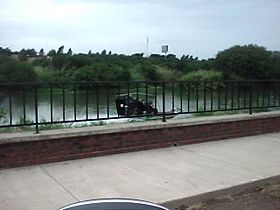
Border Patrol on the Rio Grande in Laredo, Texas.
-
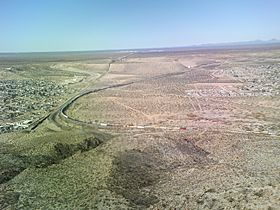
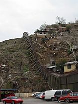
The start of the border fence in New Mexico, west of El Paso, Texas.
-
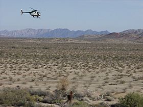
A U.S. Border Patrol helicopter near the Arizona–Sonora border in 2004.
-
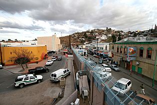
The border between Nogales, Arizona (left) and Nogales, Sonora (right).
-
On the left: Nogales, Arizona; on the right, Nogales, Sonora.
-
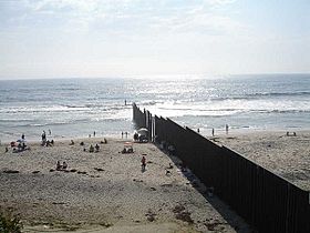
A beach in Tijuana at the border in 2006.
-
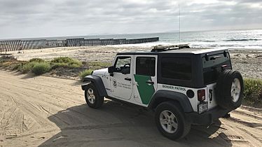
A Border Patrol vehicle near the Mexico–U.S. border.
-
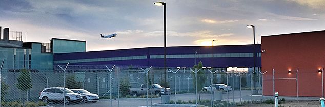
The Cross Border Xpress (CBX) bridge, connecting Tijuana Airport to the U.S.


History of the Border
Early Days and Border Formation

In the 1500s, people from different countries began to settle in this area after silver was found. This land was part of New Spain. In the early 1800s, the U.S. bought the Louisiana Purchase from France. The U.S. then started to expand westward.
After 1803, the border between the U.S. and New Spain was not clear. It was set in 1819 by the Adams–Onís Treaty between the U.S. and Spain. When Mexico became independent from Spain in 1821, the border was confirmed in the 1828 Treaty of Limits.
Mexico tried to create a safe zone at the border. They encouraged their own citizens to settle in the area now called Texas. They also offered cheap land to settlers from the U.S. in exchange for living there. However, this did not protect Mexico as hoped. Instead, Texas declared its independence in 1836 and became the Republic of Texas. In 1845, the U.S. took over Texas.
Creating the Current Border

The problems in the Texas region led to the Mexican–American War in 1846. The war ended in 1848 with the Treaty of Guadalupe Hidalgo. In this treaty, Mexico lost a huge amount of land, about 55% of its territory. This included all of what is now California, Arizona, New Mexico, Utah, Nevada, and parts of Colorado, Wyoming, Kansas, and Oklahoma. All disagreements over Texas were also settled.
Five years later, the Gadsden Purchase completed the current U.S.–Mexico border. This purchase was mainly to make way for a planned railway. After these land changes, about 300,000 people, many of them Mexican citizens, lived in the new U.S. territories. Many Mexican citizens were given free land in northern Mexico if they moved back.
Later Border Changes and Developments

The treaties of 1848 and 1884 said the border was the middle of the Rio Grande. But the river often changed its path. For example, after a flood in 1864, the river moved south. This caused some Mexican land to become part of the U.S. In 1963, Mexico got most of this land back in what was called the Chamizal dispute. The International Boundary and Water Commission (IBWC) was set up in 1889. It helps manage the border, share river water, and control floods.
The Mexican side of the border grew because it was close to the U.S. During the time of Mexican President Porfirio Díaz (1876-1910), border towns became very busy. This was because of strong ties to the U.S. and Mexican government support for U.S. investments. Railroads were built that connected northern Mexican states more to the U.S. than to Mexico. The population and mining industry grew a lot.

The U.S. passed laws to control who could enter. The Immigration Act of 1891 set up inspection stations at border crossings. The Immigration Act of 1917 required Mexicans to pass a reading test and pay a fee to enter legally. However, during World War I, these rules were temporarily stopped because more workers were needed. The Immigration Act of 1924 created the U.S. Border Patrol.
The Mexican Revolution (1910-1920) caused problems in Mexico. It also made U.S.–Mexico relations difficult. Battles and raids along the border made both countries worried about security. The Zimmermann Telegram, a secret message from Germany, tried to get Mexico to fight the U.S. This led the U.S. Federal Bureau of Investigation to watch for suspicious activities. Over time, border towns became like battlefields. This led to more rules for crossing, federal soldiers patrolling, and the building of fences. After the fighting ended, rules relaxed, but the fences stayed as a reminder of the division.
The first international bridge was built in 1910. The U.S. built its first border barrier in California between 1909 and 1911. Mexico likely built its first barrier in 1918. More barriers were added in the 1920s and 1940s.
The Banco Convention of 1905 allowed the border to change if the Rio Grande suddenly shifted. This often created "bancos," which are pieces of land cut off by river bends. The International Boundary and Water Commission would then decide which country the land belonged to. These land transfers were usually small and uninhabited.
The Rio Grande Rectification Treaty of 1933 straightened the river in the El Paso-Juárez area. Land was exchanged between the two countries so that each nation gave up an equal amount of land. The Boundary Treaty of 1970 also moved some land to build flood control channels. In 2009, some islands in the Rio Grande were exchanged between the U.S. and Mexico.
Border Crossing Points

The border between Mexico and the U.S. is the busiest international border in the world. About 350 million legal crossings happen every year.
There are 48 U.S.–Mexico border crossings with 330 entry points. At these points, people entering the U.S. must show their bags for inspection. People can cross by roads, walking paths, railroads, and ferries. Here are some of the cities on both sides of the border that are connected by crossings:
- San Diego, California (San Ysidro) – Tijuana, Baja California
- Cross Border Xpress, Otay Mesa, California – Tijuana International Airport, Baja California
- Otay Mesa, California – Tijuana, Baja California
- Tecate, California – Tecate, Baja California
- Calexico, California – Mexicali, Baja California
- Andrade, California – Los Algodones, Baja California
- San Luis, Arizona – San Luis Río Colorado, Sonora
- Lukeville, Arizona – Sonoyta, Sonora
- Sasabe, Arizona – Altar, Sonora
- Nogales, Arizona – Nogales, Sonora
- Naco, Arizona – Naco, Sonora
- Douglas, Arizona – Agua Prieta, Sonora
- Antelope Wells, New Mexico – El Berrendo, Chihuahua
- Columbus, New Mexico – Palomas, Chihuahua
- Santa Teresa, New Mexico – San Jerónimo, Chihuahua
- El Paso, Texas – Ciudad Juárez, Chihuahua
- Fabens, Texas – Práxedis G. Guerrero, Chihuahua municipality
- Fort Hancock, Texas – El Porvenir, Chihuahua
- Presidio, Texas – Ojinaga, Chihuahua
- Heath Canyon, Texas – La Linda, Coahuila (closed)
- Del Rio, Texas – Ciudad Acuña, Coahuila
- Eagle Pass, Texas – Piedras Negras, Coahuila
- Laredo, Texas – Nuevo Laredo, Tamaulipas
- Laredo, Texas – Colombia, Nuevo León
- Falcon Heights, Texas – Presa Falcón, Tamaulipas
- Roma, Texas – Ciudad Miguel Alemán, Tamaulipas
- Rio Grande City, Texas – Ciudad Camargo, Tamaulipas
- Los Ebanos, Texas – Gustavo Díaz Ordaz, Tamaulipas
- Mission, Texas – Reynosa, Tamaulipas
- Hidalgo, Texas – Reynosa, Tamaulipas
- Pharr, Texas – Reynosa, Tamaulipas
- Donna, Texas – Rio Bravo, Tamaulipas
- Progreso, Texas – Nuevo Progreso, Tamaulipas
- Los Indios, Texas – Matamoros, Tamaulipas
- Brownsville, Texas – Matamoros, Tamaulipas
The total number of people living in the border areas (counties and cities right along the border) is about 12 million.
Tijuana-San Ysidro Border Crossing
.jpg)
The San Ysidro Port of Entry is between San Ysidro, California and Tijuana, Baja California. Around 50,000 vehicles and 25,000 people cross here every day. In the U.S., I-5 goes directly to Tijuana. In 2005, over 17 million vehicles and 50 million people entered the U.S. through San Ysidro. Some people who cross here are "transfronterizos." These are American citizens who live in Mexico but go to school in the U.S.
This crossing affects the daily lives of people in these border towns. Many Americans live in Tijuana and other nearby Mexican cities. They travel to the U.S. daily for work. Also, many Mexicans cross daily to work in the U.S. In 1999, about 7.6% of Tijuana's workers were employed in San Diego.

The average wait time to cross into the U.S. is about an hour. The many cars crossing daily cause air pollution in San Ysidro and Tijuana. Vehicle pollution can lead to health problems like breathing issues. The long waits can also cause stress for people who cross often. The San Ysidro border is heavily watched. It has three walls, border patrol agents, and U.S. Immigration and Customs Enforcement.
Tijuana is becoming a popular place for developers from San Diego. This is because of its growing economy, lower living costs, and closeness to San Diego. While this helps tourism, it can make it harder for people with lower incomes to afford living in Tijuana.
Western Hemisphere Travel Rules

In 2006, the U.S. Department of Homeland Security (DHS) announced new rules for identifying people entering the U.S. These rules started in 2007. To enter the U.S. by air, you need one of nine types of identification. These include a valid passport, a passport card, or a special state enhanced driver's license. Other options include trusted traveler program cards like Global Entry or NEXUS.
In August 2015, Mexico started a rule. Foreign citizens planning to stay in Mexico for more than seven days or traveling for business must pay a fee and show their passport.
Border Zone Policies

The La Paz Agreement says the official "border area" is 100 kilometers (62 miles) on each side of the border. This zone goes from the Gulf of Mexico to the Pacific Ocean. There is also a special "100-mile border zone" in the U.S.
100-Mile Border Zone
The U.S. has a 100-mile (160 km) border zone around all its external borders, including coasts. This means it covers about two-thirds of the U.S. population. Many large U.S. cities and several entire states are within this zone. The U.S. Department of Justice created this zone based on the Immigration and Nationality Act of 1952. Officials from Customs and Border Protection (CBP) can stop and search people within this zone. They can also enter private property without a special paper within 25 miles (40 km) of the border. They can also set up checkpoints.
The Fourth Amendment protects people from unfair searches. However, this protection is different at borders or border crossings. This means that many people in the U.S. can be stopped and searched by CBP.
Students Crossing the Border

Many schools near the border in the U.S. have students who live in Mexico. These are "transborder students." They live in Mexico but attend school in the U.S. Thousands of students from elementary to high school cross the Mexican-American border daily. They often wake up very early to wait in long lines to cross into the U.S. After crossing, they find a ride to school. Many students come to America for the chance to get a better education. The U.S. education system is often more developed. Students who go to school in America have a better chance of going to college in the U.S. In many parts of Mexico, schooling is only required until age sixteen. Many transborder students are U.S. citizens by birth. U.S.-born students have the right to an American education, even if they live in Mexico. In places like San Diego and Tijuana, it is much cheaper to live in Mexico. San Diego has a high cost of living, so many families move to Tijuana because it is more affordable.
To make sure only students who are allowed to get an education in the U.S. do so, some border schools ask for official documents like bills or mail.
Border Wall Construction
In 2006, during the Bush administration, the U.S. government planned to build a border fence. This plan included many separate fences made of steel and concrete. Almost 600 kilometers (370 miles) of fence were built. Between these fences were cameras, sensors, National Guard soldiers, and special police teams. This led to the idea of a "virtual fence." Building the fence started in 2006, costing about $2.8 million per mile. In 2010, the project stopped because it was too expensive. About 640 kilometers (400 miles) of new or rebuilt barriers were completed.
-
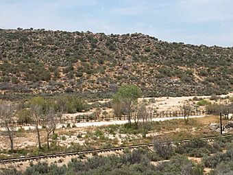
Part of the border near Jacumba, California, in 2003.
-
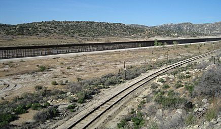
The same part of the border near Jacumba, California, in 2009, with better security.


Recent Wall Efforts
.jpg)
In 2016, Donald Trump, running for president, suggested building a border wall to control immigration. He said Mexico would pay for it. After he became president, in 2017, Trump signed an order to start building the wall. Mexican President Enrique Peña Nieto said Mexico would not pay. Trump then said he might put a special tax on Mexican goods. Mexico did not make any payments.
In September 2017, California's Attorney General Xavier Becerra sued the Trump administration. He said they were going too fast with wall construction. By the end of 2017, Mexico had not agreed to pay for the wall. The U.S. Congress had not approved money for a new wall beyond what was already planned.
In June 2018, the Trump administration created a new policy. It involved separating parents from their children at the Mexican border. People asking for safety at official entry points were often turned away. The U.S. and Mexico also put special taxes on each other's goods.

In November 2018, the Trump administration announced new rules. These rules would deny safety to anyone who crossed into the U.S. illegally. Groups that protect rights criticized this. Several groups filed a lawsuit to challenge the rule. A judge ruled against the administration, stopping the rule from being enforced. The administration appealed, but the Supreme Court did not allow the ban to be enforced.
In 2018, U.S. border agents arrested a record number of families (107,212). This record was broken in the next five months (October 2018 to February 2019) with 136,150 families arrested. In March 2019, Trump threatened to close the border, which would stop trade between the countries.
Proposed Wall Details

When he was running for president, Trump thought a border wall would cost $8 to $12 billion. He believed Mexico would pay for it. However, cost estimates for the wall varied greatly. In early 2017, the DHS estimated the cost at $22 billion. Other estimates were much higher.
In 2017, several construction companies planned to try for the contract. The Customs and Border Protection agency set aside $20 million to build half-million-dollar models of the wall. At that time, Congress had only approved money to keep up the existing wall, not to build new parts. The DHS suggested the wall should be 18 to 30 feet (5.5 to 9.1 meters) high. It also suggested it should be up to 6 feet (1.8 meters) deep to stop tunnels.
During the Trump administration, 455 miles (732 km) were added to the border barrier. President Joe Biden has stopped the construction of the wall. He ended the national emergency that Trump had used to build it.
Biden Administration and Border Crossings
In the 2021 financial year, the U.S. Border Patrol stopped over 1.7 million people crossing the U.S.-Mexico border illegally. This was the highest number ever recorded. In 2021, more different groups of people were stopped at the border.
In February 2024, a group of politicians asked President Biden not to take control of the Texas National Guard. This was because Texas wanted to do more to stop illegal immigration at the border.
Help for People at the Border

Groups like Humane Borders and No More Deaths provide water to help people crossing the Arizona desert. This helps reduce deaths among immigrants traveling through the harsh desert. A rule passed in 2010 allows water barrels to be placed on certain roads.

Images for kids
-
Going into Mexico from El Paso, Texas, U.S.
-
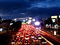
Thousands of cars waiting to cross the border in Tijuana.
-
A passport stamp from entering Tijuana, Baja California.
,_June_2016.jpg)


See also
 In Spanish: Frontera entre Estados Unidos y México para niños
