
Rio Grande facts for kids
Quick facts for kids Rio Grande |
|
|---|---|

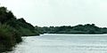
The Rio Grande at Big Bend National Park,
on the Mexico–U.S. border |
|

Map of the Rio Grande drainage basin
|
|
| Country | United States, Mexico |
| State | Colorado, New Mexico, Texas, Chihuahua, Coahuila, Nuevo León, Tamaulipas |
| Physical characteristics | |
| Main source | Canby Mountain, Continental Divide San Juan Mountains, Rio Grande National Forest, Colorado, United States 12,000 ft (3,700 m) 37°47′52″N 107°32′18″W / 37.79778°N 107.53833°W |
| River mouth | Gulf of Mexico Cameron County, Texas; Matamoros, Tamaulipas 0 ft (0 m) 25°57′22″N 97°8′43″W / 25.95611°N 97.14528°W |
| Length | 1,896 mi (3,051 km) |
| Basin features | |
| Basin size | 182,200 sq mi (472,000 km2) |
| Tributaries |
|
The Rio Grande is a very important river in the southwest United States and northern Mexico. It starts in south-central Colorado and flows all the way to the Gulf of Mexico. After going through New Mexico, it forms part of the border between the United States and Mexico. In the late 1980s, the river was about 1,896 miles (3,051 km) long. Its length can change a bit over time. The Rio Grande is one of the longest rivers in North America.
This river acts as a natural border between the U.S. state of Texas and the Mexican states of Chihuahua, Coahuila, Nuevo León, and Tamaulipas. A small part of the river also borders Texas and New Mexico. Since the mid-1900s, a lot of water from the river has been used by farms and cities. Many large diversion dams also take water. Because of this, only about 20% of its natural water now reaches the Gulf of Mexico. Near the end of the river, the Rio Grande Valley is a key farming area.
The area of land that drains into the Rio Grande is called its watershed. This area covers about 182,200 square miles (472,000 km2). Some other areas that don't always drain into the river are sometimes included. If they are, the total size can grow to about 336,000 square miles (870,000 km2).
Contents
Where the Rio Grande Flows

The Rio Grande starts high up in the San Juan Mountains of Colorado. It begins where several streams meet at the base of Canby Mountain. This spot is just east of the Continental Divide. From there, the river flows through the San Luis Valley. Then it heads south into the Middle Rio Grande Valley in New Mexico.
The river carves through the Rio Grande Gorge near Taos. It then flows towards Española. Here, it gets more water from the San Juan-Chama Diversion Project and the Rio Chama. The river continues south through the desert cities of Albuquerque and Las Cruces. It also passes by El Paso, Texas and Ciudad Juárez. In the Albuquerque area, the river flows past old Pueblo villages like Sandia Pueblo and Isleta Pueblo. After El Paso, it becomes part of the border between the United States and Mexico.
River's Length and Depth
The official border part of the river is between 889 miles (1,431 km) and 1,248 miles (2,008 km) long. This depends on how it is measured. A major river that joins the Rio Grande is the Rio Conchos. It enters below El Paso and provides most of the water for the border section. Other rivers that join are the Pecos and the smaller Devils. These join at the Amistad Dam.
Even though the Rio Grande is long, large ships cannot travel on it. Smaller passenger or cargo boats also don't use it much. It's only navigable by small boats in a few spots. At its deepest, the river is about 60 feet (18 m) deep.
River's Journey and Environment
The Rio Grande starts in high mountains. It flows at high elevations for much of its journey. For example, Albuquerque is 5,312 feet (1,619 m) above sea level. El Paso is 3,762 feet (1,147 m) high. In New Mexico, the river flows through the Rio Grande rift. It moves from one basin filled with sediment to another. It cuts canyons between these basins. The river supports a special bosque ecosystem on its flood plain.
East of El Paso, the river flows through a desert. Farming with irrigation happens along most of the river. It is especially common in the subtropical Lower Rio Grande Valley. The river ends in a small, sandy delta at the Gulf of Mexico. In 2001 and 2002, a sandbar blocked the river's mouth. This stopped it from flowing into the Gulf. In 2003, strong river flows cleared the sandbar.
River Travel and Bridges
For much of the 1800s, people used steamboats on the Rio Grande. Over 200 different steamboats traveled between the river's mouth near Brownsville and Rio Grande City, Texas. During the Mexican–American War in 1846, the U.S. government used many steamboats from the Ohio and Mississippi Rivers. They moved them to the Rio Grande to help the U.S. Army.
The Brownsville & Matamoros International Bridge was built in 1910. It is a large swing bridge that connects Brownsville with Matamoros, Tamaulipas. Cars still use it today. The swing part of the bridge has not been used since the early 1900s. This was when the large steamboats stopped using the river. A new rail bridge called the West Rail International Crossing opened in August 2015. It is about 15 miles west of the old bridge. This new bridge moved all train traffic out of downtown Brownsville and Matamoros. It was the first new international rail crossing between the U.S. and Mexico in 105 years.
At the mouth of the Rio Grande, on the Mexican side, was a big trading port called Bagdad, Tamaulipas. During the American Civil War, this was the only legal port for the Confederacy. European warships stayed offshore to keep the port neutral. They successfully did this throughout the war. This port was for shallow-draft boats. Smaller vessels carried goods to and from bigger cargo ships anchored offshore. These larger ships could not cross the shallow sandbar at the river's mouth. The port traded European military supplies for cotton.
Key Moments in Rio Grande History


,_June_2016.jpg)
In the late 1830s and early 1840s, the Rio Grande was part of a border disagreement. Mexico said the border was at the Nueces River. But the new Republic of Texas said it was the Rio Grande. This disagreement helped lead to the U.S. invasion of Mexico in 1846. Texas had just joined the U.S. as a new state. Since 1848, the Rio Grande has been the border between Mexico and the United States. This border runs from El Paso, Texas and Ciudad Juárez to the Gulf of Mexico. Because Mexico had ended slavery in 1828, some Texan slaves used the river as a way to escape to freedom.
In 1899, the river's path slowly changed. A channel was dug to help control floods. This moved the river and created an area called Cordova Island. This island became the center of the Chamizal dispute. It took many years to solve this disagreement.
In 1944, the U.S. and Mexico signed a treaty about the river. In 1997, the U.S. named the Rio Grande one of the American Heritage Rivers. Two parts of the Rio Grande are special National Wild and Scenic Rivers System areas. One is in northern New Mexico, and the other is in Texas at Big Bend National Park.
In 2001 and 2002, a 328-foot (100 m)-wide sandbar formed at the river's mouth. This was the first time in history the Rio Grande did not flow into the Gulf of Mexico. The sandbar was removed by dredging, but it quickly came back. Rains the next year washed it away, but it returned in 2002. By late 2003, the river finally reached the Gulf again.
How the River is Managed

The United States and Mexico share the water of the Rio Grande. This is done through agreements managed by the International Boundary and Water Commission (IBWC). The most important agreements were signed in 1906 and 1944. The IBWC started in 1889 to maintain the border. Today, the IBWC also divides the river's water between the two countries. It also helps with flood control and keeping the water clean.
How the U.S. uses its share of the water is set by the Rio Grande Compact. This is an agreement between Colorado, New Mexico, and Texas. There are more users who want water from the Rio Grande than there is water in the river. This means the water is "over-appropriated." Because of dry weather and too much use, the part of the river from El Paso to Ojinaga has been called "The Forgotten River." This name highlights its poor condition.

Many dams have been built on the Rio Grande. These include Rio Grande Dam, Cochiti Dam, Elephant Butte Dam, Caballo Dam, Amistad Dam, Falcon Dam, Anzalduas Dam, and Retamal Dam. In southern New Mexico and the upper part of the Texas border, the river's flow gets smaller. Water taken out, mostly for farm irrigation, makes the flow decrease even more. By the time the river reaches Presidio, there is often little or no water left. Below Presidio, the Rio Conchos adds water back to the river. Near Presidio, the river's flow is often zero. Its average flow is 178 cubic feet per second (5 m3/s). This is much less than the 945 cubic feet per second (27 m3/s) at Elephant Butte Dam. With water from other rivers, the Rio Grande's flow increases to its highest average of 3,504 cubic feet per second (99 m3/s) near Rio Grande City. Large amounts of water are taken out for irrigation below Rio Grande City. This reduces the river's average flow to 889 cubic feet per second (25 m3/s) at Brownsville and Matamoros.
Major River Crossings
There are several important places where people can cross the border along the Rio Grande. These crossings connect cities in the U.S. and Mexico.
- Ciudad Juárez and El Paso, Texas
- Presidio and Ojinaga
- Laredo, Texas and Nuevo Laredo
- McAllen, Texas and Reynosa
- Brownsville and Matamoros
Other notable border towns include:
Names and How to Say Them

In Spanish, Río Grande means "Big River." Río Grande del Norte means "Great River of the North." In English, you can say Rio Grande in a couple of ways.
In Mexico, the river is known as Río Bravo or Río Bravo del Norte. The word bravo can mean "furious" or "agitated."
Historically, the Pueblo and Navajo peoples also had names for the Rio Grande/Rio Bravo:
- mets'ichi chena, in Keresan, means "Big River."
- posoge, in Tewa, means "Big River."
- paslápaane, in Tiwa, means "Big River."
- hañapakwa, in Towa, means "Great Waters."
These Pueblo names were likely used for hundreds of years before the Spanish arrived.
- Tó Baʼáadi, in Navajo, means "Female River." In Navajo culture, the direction south is seen as female.
The name Rio del Norte was often used for the upper part of the Rio Grande. This was roughly the part within today's New Mexico. It was used from the time of Spanish colonial rule until the mid-1800s. The Spanish first wrote down this name in 1582. Later, early American settlers in South Texas started using the name Rio Grande. By the late 1800s, in the United States, the name Rio Grande was used for the whole river, from Colorado to the sea.
By 1602, Río Bravo became the common Spanish name for the lower part of the river. This was the section below where it meets the Rio Conchos.
Rivers Joining the Rio Grande
The largest tributary (a river or stream that flows into a larger river) of the Rio Grande is the Rio Conchos. It adds almost twice as much water as any other river. In terms of the size of the land area that drains into it, the Pecos River is the largest.
| Tributary | Average water flow | Drainage basin size | ||
|---|---|---|---|---|
| cu ft/s | m3/s | sq mi | km2 | |
| San Juan River | 368 | 10 | 12,950 | 33,500 |
| Rio Alamo | 130 | 3.68 | 1,675 | 4,340 |
| Rio Salado | 354 | 10.0 | 23,323 | 60,400 |
| Rio San Rodrigo | 130 | 3.68 | 1,050 | 2,720 |
| Devils River | 362 | 10.3 | 137 | 355 |
| Pecos River | 265 | 7.50 | 44,402 | 115,000 |
| Rio Conchos | 848 | 24.0 | 26,400 | 68,400 |
| Rio Puerco | 39.5 | 1.1 | 7,350 | 19,000 |
| Jemez River | 59.5 | 1.68 | 1,038 | 2,688 |
| Santa Fe River | 10.9 | 0.31 | 231 | 598.3 |
| Rio Chama | 571 | 16.2 | 3,144 | 8,143 |
| Conejos River | 176 | 4.98 | 887 | 2,297 |
Images for kids
-
Rio Grande southeast of Falcon Reservoir, Municipality of Mier, Tamaulipas, Mexico (12 August 2007)
.jpg)
See also
 In Spanish: Río Bravo para niños
