
South Texas facts for kids
Quick facts for kids
South Texas
|
|
|---|---|
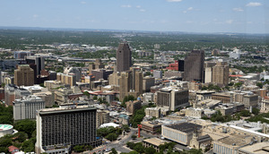
San Antonio skyline
|
|

South Texas counties in red
|
|
| Country | |
| State | |
| Largest city | San Antonio |
| Population | |
| • Total | 4,992,597 |
South Texas is a large area in the southern part of the U.S. state of Texas. It includes the city of San Antonio and stretches south from there. To the west and south, its border is the Rio Grande river, which separates Texas from Mexico. To the east, it meets the Gulf of Mexico.
About 4.96 million people live in this region, based on 2017 numbers. The very southern part of South Texas is often called the Rio Grande Valley. The eastern part, along the Gulf of Mexico, is known as the Coastal Bend.
Contents
Exploring the Geography of South Texas

South Texas doesn't have a perfectly straight northern border. It generally starts around San Antonio and goes west to the Rio Grande near Maverick County. From San Antonio, it also extends east towards the Gulf of Mexico, turning southeast near Lavaca County. This helps separate it from East Texas and Southeast Texas.
The Rio Grande forms the western and southern edges, acting as the border with Mexico. The Gulf of Mexico borders the eastern side of South Texas. This huge region is made up of 41 counties. The land is mostly flat, as it sits on a coastal plain.
Sub-regions of South Texas
Because South Texas is so big, it has different areas within it:
- The Rio Grande Valley is at the very southern tip. It has rich soil and is famous for growing citrus fruits like oranges and grapefruits.
- The Coastal Bend is the eastern part. Here, you'll find many coastal salt marshes, estuaries (where rivers meet the sea), and wetlands.
- The western and central parts are called the South Texas Plains or the Brush Country. This area is covered with Mesquite trees and fields for crops.
Counties in South Texas
South Texas is made up of many counties. Here are some of them:
- Aransas
- Atascosa
- Bee
- Bexar
- Brooks
- Calhoun
- Cameron
- DeWitt
- Dimmit
- Duval
- Frio
- Goliad
- Gonzales
- Guadalupe
- Hidalgo
- Jackson
- Jim Hogg
- Jim Wells
- Karnes
- Kenedy
- Kinney
- Kleberg
- La Salle
- Lavaca
- Live Oak
- McMullen
- Matagorda
- Maverick
- Medina
- Nueces
- Refugio
- San Patricio
- Starr
- Uvalde
- Victoria
- Webb
- Wharton
- Willacy
- Wilson
- Zapata
- Zavala
From 2010 to 2020:
- Guadalupe County grew the fastest, with a 31.3% increase in people.
- Refugio County was the slowest growing, actually shrinking by 8.7%.
Major Cities in South Texas

South Texas is home to many important cities. Here are the largest ones:
| Region Rank | City | 2020 Census | 2010 Census | % change | County |
|---|---|---|---|---|---|
| 1 | San Antonio | 1,434,625 | 1,327,407 | +8.08% | Bexar County |
| 2 | Corpus Christi | 317,863 | 305,215 | +4.14% | Nueces County |
| 3 | Laredo | 263,640 | 236,091 | +11.67% | Webb County |
| 4 | Brownsville | 186,738 | 175,023 | +6.69% | Cameron County |
| 5 | McAllen | 142,210 | 129,877 | +9.50% | Hidalgo County |
| 6 | Edinburg | 100,243 | 77,100 | +30.02% | Hidalgo County |
| 7 | Mission | 85,778 | 77,058 | +11.32% | Hidalgo County |
| 8 | Pharr | 79,715 | 70,400 | +13.23% | Hidalgo County |
| 9 | Harlingen | 71,829 | 64,849 | +0.95% | Cameron County |
| 10 | Victoria | 65,534 | 62,592 | +4.70% | Victoria County |
| 11 | Schertz | 42,002 | 31,465 | +33.49% | Guadalupe County |
| 12 | Weslaco | 40,160 | 35,670 | +12.59% | Hidalgo County |
| 13 | San Juan | 35,294 | 33,856 | +4.25% | Hidalgo County |
| 14 | Seguin | 29,433 | 25,175 | +16.91% | Guadalupe County |
| 15 | Eagle Pass | 28,130 | 26,248 | +7.17% | Maverick County |
| 16 | Converse | 27,466 | 18,198 | +50.93% | Bexar County |
| 17 | Kingsville | 25,402 | 26,213 | -3.09% | Kleberg County |
| 18 | San Benito | 24,861 | 24,250 | +2.52% | Cameron County |
| 19 | Universal City | 19,720 | 18,530 | +6.42% | Bexar County |
| 20 | Alamo | 19,493 | 18,353 | +6.21% | Hidalgo County |


Rivers in South Texas
Many rivers flow through South Texas, shaping its landscape and history.
| Name | Note |
| Rio Grande | This river forms the border between Texas and Mexico. |
| Nueces River | At one time, Mexico considered this river the border with Texas. |
| San Antonio River | A famous part of this river is the San Antonio River Walk. |
| Aransas River | A short river that flows into Copano Bay. |
| Frio River | Its name means "cold" in Spanish, and it's known for its cool water. |
| Atascosa River | A short river that joins the Frio River. |
| Mission River | This river flows into Mission Bay. |
| Leona River | A smaller river that flows into the Frio River. |
| Guadalupe River | This river flows into the San Antonio Bay estuary. |
Lakes and Reservoirs
South Texas has several important lakes and reservoirs, which are often man-made lakes that store water.
- Choke Canyon Reservoir
- Lake Corpus Christi
- Falcon Lake
- Lake Amistad
- Lake Findley
- Mitchell Lake
- Lake Casa Blanca
- Brauning Lake
- Calaveras Lake
Bays and Coastal Waters
The eastern side of South Texas is bordered by the Gulf of Mexico, featuring many bays and unique waterways.

- Corpus Christi Bay
- San Antonio Bay
- Baffin Bay
- Nueces Bay
- Oso Bay
- Copano Bay
- Aransas Bay
- Matagorda Bay
- Lavaca Bay
- Redfish Bay
- Mission Bay
- Rincon Bayou - a bayou in the Nueces River Delta.
- Elm Bayou - a bayou on the Victoria-Refugio County line.
- Gulf Intracoastal Waterway - a safe water route along the Gulf of Mexico.
- Resacas of the Rio Grande Valley - old river bends that form lakes.
- Laguna Madre - a long, very salty bay that separates Padre Island from the mainland.
Islands of South Texas
Several islands are located off the coast of South Texas.
Climate and Weather in South Texas
The weather in South Texas changes a lot depending on where you are.
- Near the Mexican border, the climate is generally semi-arid, meaning it's quite dry.
- From the coast inland to just west of San Antonio, the climate is humid subtropical, which means it's warm and humid.
The weather is influenced by the Sierra Madre Oriental mountains to the west, the Gulf of Mexico to the east, and the Chihuahuan Desert to the west/northwest.
Seasonal Weather Patterns
- Summers: Along the coast, summers are very hot and humid. Inland areas like San Antonio can also be hot, but sometimes drier.
- Winters: Temperatures rarely drop below freezing, and snow is very rare, usually less than three inches. Coastal areas stay warm most of the year. Inland winters are cooler and drier.
- Rainfall: The region usually has a short wet season from March to May and another from late August to October. The rest of the year is drier. Coastal areas get more rain than inland areas.
Extreme Weather Events
- Hurricanes: These are the most dangerous weather systems for South Texas. Hurricane season runs from June to November, but the Texas coast is usually affected in August and September.
- Droughts: Sometimes, there isn't enough rain for a long time, leading to water shortages. In 2011, a severe drought caused record high temperatures and dangerous wildfires across the state.
- Tornadoes: Tornadoes can happen in South Texas, but not as often as in other parts of the state. They usually come as strong thunderstorms, mostly in summer or with cold fronts in the fall.
- Snow: Snow rarely falls south of San Antonio or on the coast. A memorable event was the 2004 Christmas Eve snowstorm, when 6 inches (150 mm) of snow fell as far south as McAllen.
Wildlife of South Texas
South Texas is home to a wide variety of animals, from reptiles to large mammals and marine life.
Reptiles
- Texas tortoise
- Texas horned lizard
- Texas spiny lizard
- Green anole
- American alligator
- Western diamondback rattlesnake
- Texas coral snake
- Desert massasauga rattlesnake
- Kemp's ridley sea turtle
- Loggerhead sea turtle
- Leatherback sea turtle
- Green sea turtle
- Hawksbill sea turtle
Mammals
- Coyote
- Javelina
- Virginia opossum
- Bobcat
- White-tailed deer
- Mountain lion
- Jaguar
- Jaguarundi
- Ocelot
- Nine-banded armadillo
- Black-tailed jackrabbit
- Desert cottontail
- Striped skunk
- Ring-tailed Cat
Sealife
- Bottlenose dolphins
- West Indian manatee
- Barracuda
- Bluefish
- Tarpon
- Tiger shark
- Red drum
- Blue crab
- Stone crab
- Fiddler crab
- Lightning whelk
- Atlantic Spanish mackerel
- King mackerel
- Pinfish
- Pigfish
- Gafftopsail catfish
- Hardhead catfish
- Atlantic cutlassfish
- Atlantic croaker
- Striped mullet
- American eel
- Black drum
- Spotted seatrout
- Greater amberjack
- Florida pompano
- Common snook
- Crevalle jack
- Tripletail
- Cobia
- Eastern oyster
- Red snapper
- Vermilion snapper
- Sheepshead
- Lane snapper
- Bull shark
- Shortfin mako
- Atlantic blue marlin
- Southern flounder
Arthropods
- Southern black widow
- Black widow
- Brown recluse
- Texas brown tarantula
- Giant desert centipede
- Texas tan tarantula
- Fire ant
Birds
- Northern mockingbird
- Laughing gull
- American herring gull
- White-winged dove
- Green jay
- Brown pelican
- American white ibis
- Great white heron
- Osprey
- Anhinga
- Monk parakeet
- Roseate spoonbill
- Reddish egret
- Red-crowned parrot
People and Culture of South Texas
Multicultural Influences
South Texas is known for its strong Hispanic culture, especially Mexican American and Tejano influences. This is because it's so close to Mexico. Tejanos and Mexicans in South Texas are descendants of Spanish and Sephardic Jewish settlers from Mexico. They also come from Mexican native groups who worked with the Spanish, like the Tlaxcaltec and Otomi peoples. Local native groups of South Texas, like the Coahuiltecans, also became part of this mix. These groups have been moving into South Texas since the early 1700s.
After the Mexican–American War in the 1840s, the Treaty of Guadalupe Hidalgo did not fully protect the land owned by Mexican settlers. The area between the Nueces River (south of San Antonio and Corpus Christi) and the Rio Grande was disputed. For a short time in 1840, a new country called the Republic of the Rio Grande was formed in this area, with Laredo as its capital. It lasted less than a year.
The Rio Grande Valley was important in several wars, including the Mexican War of Independence, the Texas Revolution, the Mexican–American War, and the American Civil War. Many historical battle sites are found here. Famous figures like General Robert E. Lee and President Zachary Taylor spent time in this region.
The Texas Rangers became well-known for their work in South Texas. They helped bring law and order to the area in the late 1800s and early 1900s, especially during raids by Mexican bandits. San Antonio has the largest African American population in South Texas.
Economy of South Texas
Rice Farming

An important part of South Texas's history and economy is the rice industry. In 1904, a special type of rice seed was brought from Japan. The Houston Chamber of Commerce and the Southern Pacific Railroad invited Japanese farmers to Texas to help grow rice. The Japanese emperor gave the farmers the special rice seed. Growing Japanese rice started in Webster, Harris County. The Saibara family is given credit for helping the Gulf Coast rice industry grow.
Getting Around South Texas
Airports
South Texas has several airports for travel.
- San Antonio International Airport
- Corpus Christi International Airport
- Laredo International Airport
- Valley International Airport
- Victoria Regional Airport
- McAllen Miller International Airport
- Brownsville/South Padre Island International Airport
- Alice International Airport
- South Texas International Airport at Edinburg
- Aransas County Airport
- Kleberg County Airport
- Duval-Freer Airport
- Mustang Beach Airport
- San José Island Airport
Passenger Trains
- The San Antonio Amtrak station serves two train lines: the Sunset Limited and the Texas Eagle. There's also a bus service (Amtrak Thruway) that connects to Harlingen, Brownsville, and McAllen, Texas.
Major Roads and Highways
South Texas has a network of interstates, U.S. routes, and state highways.
Interstate Highways
U.S. Routes
 US 59
US 59 US 77
US 77 US 83
US 83 US 87
US 87 US 90
US 90 US 181
 US 281
Texas State Highways
 TX 4
TX 4 TX 16
TX 16 TX 44
TX 44 TX 107
 TX 141
 TX 151
 TX 255
 TX 285
 TX 286
 TX 336
 TX 358
 TX 359
 TX 361
 TX 495
Bridges to Mexico
Many international bridges connect South Texas cities to Mexico.
- Laredo
- Gateway to the Americas International Bridge
- Juárez–Lincoln International Bridge
- Texas Mexican Railway International Bridge
- World Trade International Bridge
- Laredo–Colombia Solidarity International Bridge
- Eagle Pass
- Eagle Pass–Piedras Negras International Bridge
- Camino Real International Bridge
- Union Pacific International Railroad Bridge
- Brownsville
- Brownsville & Matamoros International Bridge
- Veterans International Bridge at Los Tomates
- Gateway International Bridge
- Los Indios
- Free Trade International Bridge
- Falcon Heights
- Lake Falcon Dam International Crossing
- Hidalgo
McAllen- McAllen–Hidalgo–Reynosa International Bridge
- Anzalduas International Bridge
- Pharr
- Pharr–Reynosa International Bridge
- Progreso
- Progreso–Nuevo Progreso International Bridge
- Rio Grande City
- Rio Grande City–Camargo International Bridge
- Roma
- Roma–Ciudad Miguel Alemán International Bridge
Fun Places to Visit in South Texas
South Texas offers many exciting places for visitors.
San Antonio Attractions
- San Antonio Missions National Historical Park
- The Alamo
- Tobin Center for the Performing Arts
- Six Flags Fiesta Texas
- San Antonio River Walk
- San Antonio Zoo
- SeaWorld San Antonio
- San Antonio Museum of Art
- San Antonio Stock Show & Rodeo
Corpus Christi Attractions
- Mirador de la Flor (Selena Memorial Statue)
- Texas State Aquarium
- USS Lexington Museum Ship
- Mustang Island and Mustang Island State Park
- Padre Island National Seashore near Corpus Christi
- Bayfest
- Schlitterbahn
Laredo Attractions
- San Agustin de Laredo Historic District
- Republic of the Rio Grande Capitol Building Museum
- Washington's Birthday Celebration festivities during January and February
Rio Grande Valley Attractions
- South Padre Island
- Gladys Porter Zoo in Brownsville
- Basilica of the National Shrine of Our Lady of San Juan del Valle
Other Popular Spots
Education in South Texas
Colleges and Universities
South Texas has many colleges and universities where students can continue their education.
Community Colleges
- Alamo Community College District
- San Antonio College
- Palo Alto College
- St. Philip's College
- Northeast Lakeview College
- Northwest Vista College
- Coastal Bend College
- Alice Campus
- Main Campus (Beeville)
- Kingsville Campus
- Pleasanton Campus
- Del Mar College
- Laredo Community College
- Laredo Community College South Campus
- South Texas College
- Main Campus, McAllen
- Tech Campus, McAllen
- Nursing and Allied Health Campus, McAllen
- Mid-Valley Campus, Weslaco
- Starr County Campus, Rio Grande City
- Texas State Technical College
- Texas Southmost College
Public Universities
- Texas A&M International University (Laredo)
- Texas A&M University–Corpus Christi
- Texas A&M University–Kingsville (Texas A&I)
- Texas A&M University–San Antonio
- University of Houston–Victoria
- University of Texas Health Science Center at San Antonio
- University of Texas at San Antonio
- University of Texas Rio Grande Valley (started in 2015)
- University of Texas at Brownsville
- University of Texas–Pan American
Private Universities
- Our Lady of the Lake University
- St. Mary's University
- University of the Incarnate Word
- Trinity University
- Texas Lutheran University
Sports in South Texas
The most well-known professional sports team in South Texas is the San Antonio Spurs basketball team, which plays in the NBA.
| Team | Sport | League | Venue |
|---|---|---|---|
| San Antonio Spurs | Basketball | NBA | AT&T Center |
| Rio Grande Valley Vipers | NBA G League | Bert Ogden Arena | |
| San Antonio Talons | Arena Football | AFL | Alamodome |
| Corpus Christi Hammerheads | Lone Star Football League | American Bank Center | |
| Corpus Christi Hooks | Baseball | Texas League | Whataburger Field |
| San Antonio Missions | Nelson W. Wolff Municipal Stadium | ||
| Laredo Lemurs | AAIPB | Uni-Trade Stadium | |
| Brownsville Charros | United League Baseball | Harlingen Field | |
| Rio Grande Valley WhiteWings | Harlingen Field | ||
| San Antonio Rampage | Ice hockey | American Hockey League | AT&T Center |
| Corpus Christi IceRays | North American Hockey League | American Bank Center | |
| San Antonio FC | Soccer | USL Championship | Toyota Field |
| Laredo Heat | PDL | TAMIU Soccer Complex | |
| La Fiera FC | Indoor soccer | PASL | State Farm Arena |
Area Codes
Area codes help connect phone calls to different parts of South Texas.
- 210 - San Antonio, Bexar County
- 361 - Corpus Christi, Alice, Victoria, Kingsville, Rockport, Falfurrias
- 726 - San Antonio metropolitan area
- 830 - Eagle Pass, Floresville
- 956 - Laredo, Brownsville, McAllen, Mission, Edinburg
- 979 - only the southern half of this area is in South Texas
Images for kids
-
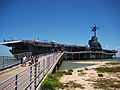
USS Lexington floating museum in Corpus Christi
-
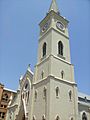
San Agustin Cathedral in Laredo's San Agustin de Laredo Historic District
-

Republic of the Rio Grande Capitol building is located in Laredo
-
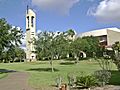
Basilica of San Juan del Valle in San Juan


See also
 In Spanish: Texas sur para niños
