Wharton County, Texas facts for kids
Quick facts for kids
Wharton County
|
|
|---|---|

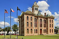
The Wharton County Courthouse in Wharton
|
|

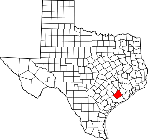
Location within the U.S. state of Texas
|
|
 Texas's location within the U.S. |
|
| Country | |
| State | |
| Founded | 1846 |
| Named for | William H. Wharton and John Austin Wharton |
| Seat | Wharton |
| Largest city | El Campo |
| Area | |
| • Total | 1,094 sq mi (2,830 km2) |
| • Land | 1,086 sq mi (2,810 km2) |
| • Water | 8.2 sq mi (21 km2) 0.8% |
| Population
(2020)
|
|
| • Total | 41,570 |
| • Density | 37.998/sq mi (14.671/km2) |
| Time zone | UTC−6 (Central) |
| • Summer (DST) | UTC−5 (CDT) |
| Congressional district | 22nd |

Wharton County is a place in Texas, USA. In 2020, about 41,570 people lived there. The main town, or county seat, is Wharton. The county got its name from two brothers, William Harris Wharton and John Austin Wharton.
Wharton County is part of a larger area around El Campo. It's also connected to the bigger Houston-The Woodlands area, which is a major part of Texas.
Contents
About Wharton County's Land and Location
Wharton County covers a total area of about 1,094 square miles (2,833 square kilometers). Most of this area, about 1,086 square miles (2,813 square kilometers), is land. The rest, about 8.2 square miles (21 square kilometers), is water.
The county is located about 130 miles (209 kilometers) southeast of Austin, the capital of Texas.
Neighboring Counties
Wharton County shares its borders with several other counties:
- Austin County to the north
- Fort Bend County to the northeast
- Brazoria County to the east
- Matagorda County to the southeast
- Jackson County to the southwest
- Colorado County to the northwest
People Living in Wharton County
The number of people living in Wharton County has changed over time. Here's a look at the population from 1850 to 2020:
| Historical population | |||
|---|---|---|---|
| Census | Pop. | %± | |
| 1850 | 1,752 | — | |
| 1860 | 3,380 | 92.9% | |
| 1870 | 3,426 | 1.4% | |
| 1880 | 4,459 | 30.2% | |
| 1890 | 7,584 | 70.1% | |
| 1900 | 16,942 | 123.4% | |
| 1910 | 21,123 | 24.7% | |
| 1920 | 24,288 | 15.0% | |
| 1930 | 29,681 | 22.2% | |
| 1940 | 36,158 | 21.8% | |
| 1950 | 36,077 | −0.2% | |
| 1960 | 38,152 | 5.8% | |
| 1970 | 36,729 | −3.7% | |
| 1980 | 40,242 | 9.6% | |
| 1990 | 39,955 | −0.7% | |
| 2000 | 41,188 | 3.1% | |
| 2010 | 41,280 | 0.2% | |
| 2020 | 41,570 | 0.7% | |
| U.S. Decennial Census 1850–2010 2010 2020 |
|||
In 2000, there were 41,188 people living in the county. The population density was about 38 people per square mile (15 people per square kilometer).
Most people spoke English (73.8%), but a good number also spoke Spanish (24.0%) or Czech (2.0%) as their first language.
The median age in the county was 35 years old. This means half the people were younger than 35 and half were older. About 28.7% of the population was under 18 years old.
A Look at History: Slavery in Wharton County
In the 1860s, a map created by the United States government showed important information about the population. This map used data from the 1860 national census. It showed that 80.9% of the people in Wharton County were enslaved. At that time, the county had a total of 3,380 people.
This was the highest percentage of enslaved people in any single county in Texas. The number of enslaved people across Texas grew a lot between 1850 and 1860. This was because new areas were being developed for farming.
Getting Around Wharton County: Transportation
Airports
There are two general aviation airports in Wharton County. These airports are used for smaller planes, not big commercial flights.
- El Campo Metropolitan Airport is located southwest of El Campo.
- Wharton Regional Airport is located in the southwestern part of Wharton.
Main Roads and Highways
Several important roads run through Wharton County, helping people travel around.
 U.S. Highway 59: This highway is being updated to become
  Interstate 69 in many places.
 U.S. Highway 90 Alternate
 State Highway 60
 State Highway 71
 Farm to Market Road 102
 Farm to Market Road 442
 Farm to Market Road 1160
 Farm to Market Road 1301
Towns and Communities in Wharton County
Wharton County has several cities and smaller communities where people live.
Cities
- East Bernard
- El Campo
- Wharton (This is the county seat, the main town for county government.)
Census-Designated Places
These are areas that are like towns but are not officially incorporated as cities.
Unincorporated Communities
These are smaller communities that are not part of any city or census-designated place.
Ghost Towns
These are places that used to be communities but are now abandoned or have very few people living there.
- Dorman
- Hahn
- Jones Creek
- Mackay
- Nottawa
- Peach Creek
- Plainview
- Preston
- Round Mott
- Sorrelle
- Taiton
- Waterville
See also
 In Spanish: Condado de Wharton para niños
 | John T. Biggers |
 | Thomas Blackshear |
 | Mark Bradford |
 | Beverly Buchanan |


