
Taiton, Texas facts for kids
Quick facts for kids
Taiton, Texas
|
|
|---|---|

Taiton, Texas
Location in Texas

Taiton, Texas
Location in the United States
|
|
| Country | United States |
| State | Texas |
| County | Wharton |
| Elevation | 135 ft (41 m) |
| Time zone | UTC-6 (Central (CST)) |
| • Summer (DST) | UTC-5 (CDT) |
| ZIP code |
77442
|
| Area code(s) | 979 |
Taiton, also called Tait or York, was a small community in Wharton County, Texas, United States. It was an unincorporated area, meaning it didn't have its own local government. Taiton was located about 5 miles (8 km) north of a newer town called New Taiton, along State Highway 71.
Taiton's population was largest around 1910. After that, fewer people lived there. It seems that Taiton either moved south to New Taiton or was replaced by it. Today, Taiton is not marked on maps or with road signs. There are very few homes left in the area. This suggests that Taiton has become a ghost town, a place where most people have left.
History of Taiton
Taiton was found along State Highway 71, north of New Taiton. The first American settlers arrived in this area in 1886. Later, in 1894, many German and Czech immigrants came. They were looking for land near El Campo to farm.
Early Days and Growth
The community was first named Tait. But in 1896, its name changed to Taiton when a post office opened there. In 1901, a person named Ignace Jurasek gave land for a new school. This new school replaced an older one. By 1903, Taiton had a general store, opened by B. E. Medina, and a place for dances.
In 1905, the school had 75 students and one teacher. Farmers in Taiton grew crops like corn, cotton, rice, and watermelons. They also raised cattle. By 1910, Taiton's population grew to 800 people. The town then had a dry-goods store, a buyer for farm products, and several grocery stores. St. John Nepomucene Catholic Church was built in 1912.
Decline and Changes
After 1915, Taiton's population started to shrink. In 1926, the school had two teachers and 108 students. However, only 20 people lived in the community itself. The post office closed sometime in the 1930s.
By 1936, a new community called New Taiton appeared on county maps. It had a church, a factory, and some homes. In the 1940s, the Taiton school joined with another school from the Rancho Grande community. They moved to a new location. In 1947, Taiton still had 80 residents. It included the church, the school, and two stores.
By 1965, Taiton was no longer marked on maps at its original spot. However, the small community of Hahn was still shown. In the 1960s, the Taiton area covered about 35 square miles and had 325 residents.
-
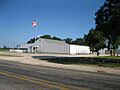
The Taiton Community Center is located in New Taiton, south of the original Taiton.
-
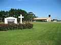
St John Nepomucene Catholic Church is found in New Taiton.


