Hahn, Texas facts for kids
Quick facts for kids
Hahn, Texas
|
|
|---|---|

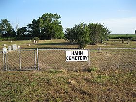
Hahn Cemetery is on FM 2546 to the east of FM 1160.
|
|
| Country | United States |
| State | Texas |
| County | Wharton |
| Elevation | 128 ft (39 m) |
| Time zone | UTC-6 (Central (CST)) |
| • Summer (DST) | UTC-5 (CDT) |
| ZIP code |
77437
|
| Area code(s) | 979 |
| GNIS feature ID | 1379876 |
Hahn or Hahn Prairie is a small, quiet community in Wharton County, Texas. It's not a big city with its own government, but rather a collection of homes and farms in the countryside. You'll find it in the northwestern part of Wharton County, where two roads, FM 1160 and FM 2546, meet. Even though there aren't road signs saying "Welcome to Hahn," you can spot the nearby Hahn Cemetery. There are a few houses clustered around the crossroads. The area around Hahn is mostly farmland, and you might even see some natural gas wells.
History
Hahn Prairie was once a small settlement located on the old Hahn Ranch. It was about 16 miles (26 km) northwest of Wharton, Texas. A post office opened here in 1897, which means people could send and receive mail right in their community. By 1905, Hahn had a school with two teachers and 32 students, showing it was a place where families lived.
Ten years later, in 1910, about 50 people lived in Hahn. However, the post office closed in 1929. By 1933, the community had shrunk to only 20 people and just one store. The main community area was abandoned in the 1940s. Even though it was much smaller, state highway maps still showed Hahn Prairie as late as 1989. By that time, only the school, the cemetery, and a few homes remained.
Where is Hahn?
Hahn is located where FM 1160 (which runs north and south) crosses FM 2546 (which runs east and west). This location was marked on maps as early as 1965.
Hahn is about 12.2 miles (19.6 km) north of Louise. It is also about 6.3 miles (10.1 km) southwest of New Taiton along FM 1160. The crossroads of Hahn are 4.2 miles (6.8 km) west of State Highway 71. They are also 3.3 miles (5.3 km) east of Mount Pilgrim Baptist Church on FM 2546.
The Hahn Cemetery is located about 0.7 miles (1.1 km) east on FM 2546. There are no road signs that specifically say "Hahn." However, the nearby cemetery is clearly marked. You will find about a dozen homes grouped near the road junction. Two creeks flow south near Hahn: West Mustang Creek to the east and Porter's Creek to the west. The area around Hahn has many natural gas wells and some oil wells.
 | Claudette Colvin |
 | Myrlie Evers-Williams |
 | Alberta Odell Jones |


