Brazoria County, Texas facts for kids
Quick facts for kids
Brazoria County
|
||
|---|---|---|

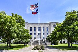
The Brazoria County Courthouse in Angleton
|
||
|
||

Location within the U.S. state of Texas
|
||
 Texas's location within the U.S. |
||
| Country | ||
| State | ||
| Founded | 1836 | |
| Named for | Brazos River | |
| Seat | Angleton | |
| Largest city | Pearland | |
| Area | ||
| • Total | 1,609 sq mi (4,170 km2) | |
| • Land | 1,358 sq mi (3,520 km2) | |
| • Water | 251 sq mi (650 km2) 16%% | |
| Population
(2020)
|
||
| • Total | 372,031 | |
| • Density | 272.9/sq mi (105.4/km2) | |
| Time zone | UTC−6 (Central) | |
| • Summer (DST) | UTC−5 (CDT) | |
| Congressional districts | 9th, 14th, 22nd | |
Brazoria County is a county in the U.S. state of Texas. In 2020, about 372,031 people lived there. The county seat is Angleton.
Brazoria County is part of the larger Houston-The Woodlands-Sugar Land area. It is located in the Gulf Coast region of Texas. Its largest city is Pearland. The county is named after the Brazos River, which flows through it.
This area was the first place where Anglo-American settlers arrived in Texas in 1821. It also includes Columbia and Velasco, Texas, which were early capital cities of the Republic of Texas. The highest point in Brazoria County is Shelton's Shack, which is 342 feet (104 meters) above sea level.
Contents
History of Brazoria County
Brazoria County gets its name from the Brazos River. The first 300 American settlers, led by Stephen F. Austin, arrived here in 1821. Many important events that led to the Texas Revolution happened in Brazoria County. In 1832, the Mexican government made Brazoria a separate district. It became one of Texas's first counties when Texas gained independence in 1836.
Joel Walter Robison, an early resident, fought in the Texas Revolution. He later served in the Texas House of Representatives.
Stephen F. Austin was first buried at Gulf Prairie Cemetery in Jones Creek. This was on his brother-in-law's Peach Point Plantation. In 1910, his remains were moved to Austin, the state capital. The town of West Columbia was the first capital of Texas before the revolution.
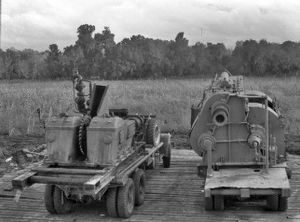
The Hastings Oil Field was found in 1934. It produced a lot of oil from deep underground. By 1954, about 242 million barrels of oil had been taken from this field.
Lake Jackson was built in the early 1940s. It provided homes for workers at a new Dow Chemical Company factory in nearby Freeport. Brazoria County has both rural and suburban areas. It is part of the larger Houston metropolitan area.
In June 2016, the Brazos River flooded. This caused some parts of Brazoria County to be evacuated.
Geography of Brazoria County
Brazoria County covers a total area of 1,609 square miles (4,167 square kilometers). About 1,358 square miles (3,517 square kilometers) is land. The remaining 251 square miles (650 square kilometers) is water, which is about 16% of its total area.
Neighboring Counties
- Harris County (north)
- Galveston County (northeast)
- Gulf of Mexico (southeast)
- Matagorda County (southwest)
- Wharton County (west)
- Fort Bend County (northwest)
Protected Natural Areas
Communities in Brazoria County
Brazoria County has many different communities.
Cities
Towns
Villages
Census-Designated Places
These are areas that are like towns but are not officially incorporated.
- Damon
- East Columbia
- Rosharon
- Ryan Acres
- Wild Peach Village
Unincorporated Communities
These are small communities that are not part of any city or town.
- Amsterdam
- Anchor
- Brazosport
- Bryan Beach
- Chenango
- China Grove
- Chocolate Bayou
- Danciger
- English
- Four Corners
- Hinkle's Ferry
- Lochridge
- Old Ocean
- Otey
- Silverlake
- Snipe
- Turtle Cove
Ghost Towns
These are towns that no longer exist or are abandoned.
- Hasima
- Hastings
- Lake Barbara
- Mims
- Oakland
- Perry's Landing
- Velasco
Population and People
| Historical population | |||
|---|---|---|---|
| Census | Pop. | %± | |
| 1850 | 4,841 | — | |
| 1860 | 7,143 | 47.6% | |
| 1870 | 7,527 | 5.4% | |
| 1880 | 9,774 | 29.9% | |
| 1890 | 11,506 | 17.7% | |
| 1900 | 14,861 | 29.2% | |
| 1910 | 13,299 | −10.5% | |
| 1920 | 20,614 | 55.0% | |
| 1930 | 23,054 | 11.8% | |
| 1940 | 27,069 | 17.4% | |
| 1950 | 46,549 | 72.0% | |
| 1960 | 76,204 | 63.7% | |
| 1970 | 108,312 | 42.1% | |
| 1980 | 169,587 | 56.6% | |
| 1990 | 191,707 | 13.0% | |
| 2000 | 241,767 | 26.1% | |
| 2010 | 313,166 | 29.5% | |
| 2020 | 372,031 | 18.8% | |
| 2023 (est.) | 398,938 | 27.4% | |
| U.S. Decennial Census 1850–2010 2010–2020 |
|||
In 2000, Brazoria County had 241,767 people. By 2010, the population grew to 313,166. In 2020, it reached 372,031 people.
In the late 1800s, most people in Brazoria County were Black. Many were formerly enslaved people who worked on plantations. However, after Jim Crow laws were put in place, many African Americans moved to Houston. This made the county mostly white. By 2022, due to growth of different groups, white people were no longer the majority in the county.
| Race / Ethnicity (NH = Non-Hispanic) | Pop 2000 | Pop 2010 | Pop 2020 | % 2000 | % 2010 | % 2020 |
|---|---|---|---|---|---|---|
| White alone (NH) | 158,052 | 166,674 | 161,833 | 65.37% | 53.22% | 43.50% |
| Black or African American alone (NH) | 20,183 | 36,880 | 53,668 | 8.35% | 11.78% | 14.43% |
| Native American or Alaska Native alone (NH) | 828 | 1,013 | 1,022 | 0.34% | 0.32% | 0.27% |
| Asian alone (NH) | 4,776 | 17,013 | 26,231 | 1.98% | 5.43% | 7.05% |
| Pacific Islander alone (NH) | 54 | 58 | 129 | 0.02% | 0.02% | 0.03% |
| Other race alone (NH) | 215 | 472 | 1,374 | 0.09% | 0.15% | 0.37% |
| Mixed race or Multiracial (NH) | 2,596 | 4,413 | 12,572 | 1.07% | 1.41% | 3.38% |
| Hispanic or Latino (any race) | 55,063 | 86,643 | 115,202 | 22.78% | 27.67% | 30.97% |
| Total | 241,767 | 313,166 | 372,031 | 100.00% | 100.00% | 100.00% |
Education in Brazoria County
Many different school districts serve students in Brazoria County. These include:
- Alvin ISD
- Angleton ISD
- Brazosport ISD
- Columbia-Brazoria ISD
- Danbury ISD
- Damon ISD
- Friendswood ISD
- Pearland ISD
- Sweeny ISD
For higher education, there are two colleges: Alvin Community College and Brazosport College. Alvin Community College serves areas like Alvin, Danbury, and Pearland. Brazosport College serves Angleton, Brazosport, Columbia-Brazoria, Damon, and Sweeny areas.
The Brazoria County Library System has many branches. You can find them in Alvin, Angleton, Brazoria, Clute, Danbury, Freeport, Lake Jackson, Manvel, Pearland, Sweeny, and West Columbia. The county also has the Brazoria County Historical Museum.
Transportation in Brazoria County
Major Highways
Airports
The Texas Gulf Coast Regional Airport is the main public airport in Brazoria County.
There are also several private airports open for public use:
- Flyin' B Airport
- Skyway Manor Airport in Pearland
- Pearland Regional Airport
The closest airport with regular flights is Houston's William P. Hobby Airport. It is located in southern Houston, in Harris County. George Bush Intercontinental Airport, a larger international airport, also serves Brazoria County.
Toll Roads
| Authority overview | |
|---|---|
| Formed | December 2003 |
| Jurisdiction | Brazoria County, Texas |
| Headquarters | Brazoria Commissioners Court |
The Brazoria County Toll Road Authority (BCTRA) manages toll lanes on TX 288. These lanes connect to other toll lanes in Harris County.
History of the Toll Road Authority
The BCTRA was created in December 2003. It was formed because the Houston area needed more roads. The authority wanted to have a say in new roads built in Brazoria County.
Roadway System
The only toll road operated by BCTRA is the Brazoria County Expressway. This expressway is located in the middle of SH 288. It starts at County Road 58 in Manvel. The BCTRA maintains it for five miles up to the Harris County line. The 288 Toll Lanes then continue into Harris County for ten more miles.
Construction on the Brazoria County Expressway started in late 2016. It was finished on November 16, 2020. You need an EZ Tag, TxTag, or TollTag to pay the tolls electronically.
See also
 In Spanish: Condado de Brazoria para niños
 | James Van Der Zee |
 | Alma Thomas |
 | Ellis Wilson |
 | Margaret Taylor-Burroughs |


