Otey, Texas facts for kids
Quick facts for kids
Otey, Texas
|
|
|---|---|

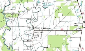
Topographic map of the Ramsey Units, July 1, 1984
|
|
| Country | United States |
| State | Texas |
| County | Brazoria |
| Time zone | UTC-6 (Central (CST)) |
| • Summer (DST) | UTC-5 (CDT) |
Otey is a small, unincorporated community in northwestern Brazoria County, Texas, United States. An unincorporated community is a place that does not have its own local government. Instead, it is part of a larger county. In 2000, about 318 people lived in Otey. It is located near the big city area of Greater Houston.
History of Otey
Otey was once home to a large farm called the Palo Alto plantation. This farm was owned by Robert and David G. Mills. They owned several big farms across Texas. Before the American Civil War, they were very wealthy.
However, after the war, during a time called Reconstruction, they lost all their money. They also lost their farms to people they owed money to. The land around the Palo Alto plantation later became part of the Ramsey Unit. This was a prison run by the Texas Department of Criminal Justice.
The Ramsey Unit started as a prison for older inmates in 1908. A post office opened in Otey in 1911. It stayed open until 1973, when mail services moved to Rosharon. In 1914, Otey had about 700 people and even a doctor. The Ramsey Unit prison had 674 inmates at that time.
In 1916, the Sugar Land Railroad built tracks from Anchor to Otey. These tracks are no longer used today. The number of people living in Otey dropped to 150 by 1958. But it grew again to 318 people between 1990 and 2000. The Ramsey Unit prison also had many farm activities. They grew crops, raised animals, had a dairy farm, and even fixed furniture.
Geography of Otey
Otey is located along Oyster Creek. It is at the very end of Farm to Market Road 655. Otey is about 12 miles (19 km) north of Angleton.
Education in Otey
Students in the Otey area attend schools operated by the Angleton Independent School District.
Images for kids


