Fort Bend County, Texas facts for kids
Quick facts for kids
Fort Bend County
|
||
---|---|---|
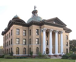
Fort Bend County Courthouse, Richmond, November 2008
|
||
|
||
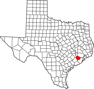
Location within the U.S. state of Texas
|
||
Texas's location within the U.S. |
||
Country | United States | |
State | Texas | |
Founded | 1838 | |
Named for | A blockhouse positioned in a bend of the Brazos River | |
Seat | Richmond | |
Largest city | Sugar Land | |
Area | ||
• Total | 885 sq mi (2,290 km2) | |
• Land | 861 sq mi (2,230 km2) | |
• Water | 24 sq mi (60 km2) 2.7% | |
Population
(2020)
|
||
• Total | 822,779 | |
• Estimate
(2022)
|
889,146 | |
• Density | 929.7/sq mi (358.96/km2) | |
Time zone | UTC−6 (Central) | |
• Summer (DST) | UTC−5 (CDT) | |
Congressional districts | 7th, 9th, 22nd |
Fort Bend County is a county located in the U.S. state of Texas. The county was founded in 1837 and organized the next year. It is named for a blockhouse at a bend of the Brazos River. The community developed around the fort in early days. The county seat is Richmond. The largest city located entirely within the county borders is Sugar Land. The largest city by population in the county is Houston; however, most of Houston's population is located in neighboring Harris County.
Fort Bend County is included in the Houston–The Woodlands–Sugar Land metropolitan statistical area. As of the 2020 census, the population was 822,779. In 2017, Forbes ranked it the fifth-fastest growing county in the United States.
In 2015, Fort Bend County became Texas's wealthiest county, with a median household income of $95,389 and a median family income of $105,944, surpassing Collin and Rockwall Counties since the 2000 census.
Contents
History
Before European settlement, the area was inhabited by Karankawa Indians. Spanish colonists generally did not reach the area during their colonization, settling more in South Texas.
After Mexico achieved independence from Spain, Anglo-Americans started entering from the east. In 1822, a group of Stephen F. Austin's colonists, headed by William Travis, built a fort at the present site of Richmond. The fort was called Fort Bend because it was built in the bend of the Brazos River. The city of Richmond was incorporated under the Republic of Texas along with 19 other towns in 1837. Fort Bend County was created from parts of Austin, Harris, and Brazoria Counties in 1838.
Fort Bend developed a plantation economy based on cotton as the commodity crop. Planters had numerous African-American slaves as laborers. By the 1850s, Fort Bend was one of six majority-black counties in Texas. In 1860, the slave population totaled 4,127, more than twice that of the 2,016 whites. Few free Blacks lived there, as Texas refused them entry.
While the area began to attract white immigrants in the late 19th century, it remained majority-Black during and after Reconstruction. Whites endeavored to control freedmen and their descendants through violence and intimidation. Freedmen and their sympathizers supported the Republican Party because of emancipation, electing their candidates to office. The state legislature was still predominately white. By the 1880s, most white residents belonged to the Democratic Party. Factional tensions were fierce, as political elements split largely along racial lines. The Jaybirds, representing the majority of the Whites, struggled to regain control from the Woodpeckers, who were made up of some whites who were consistently elected to office by the majority of African Americans, as several had served as Republican officials during Reconstruction.
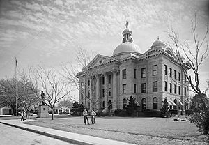
Fort Bend County was the site of the Jaybird–Woodpecker War in 1888–89. After a few murders were committed, the political feud culminated in a gun battle at the courthouse on August 16, 1889, when several more people were killed and the Woodpeckers were routed from the county seat.
Governor Lawrence Sullivan Ross sent in militia forces and declared martial law. With his support, the Jaybirds ordered a list of certain Blacks and Woodpecker officials out of the county, overthrowing the local government. The Jaybirds took over county offices and established a "White-only pre-primary," disenfranchising African Americans from the only competitive contests in the county. This device lasted until 1950, when Willie Melton and Arizona Fleming won a lawsuit against the practice in United States District Court, though it was overturned on appeal. In 1953, they ultimately won their suit when the Supreme Court of the United States declared the Jaybird primary unconstitutional in Terry v. Adams, the last of the white primary cases.
20th century to present
In the 1960s, the first of several master-planned communities that came to define the county were developed, marking the beginning of its transformation from a largely rural county dominated by railroad and oil and gas interests to a major suburban county dominated by service and manufacturing industries. Among the earliest such developments were Sugar Land's Sugar Creek and Missouri City's Quail Valley, whose golf course hosted the Houston Open during the 1973 and 1974 seasons of the PGA Tour. Another was First Colony in Sugar Land, a 9,700-acre development commenced in the 1970s by Houston developer Gerald D. Hines that eventually became the southwest Greater Houston area's main retail hub, anchored by First Colony Mall and Sugar Land Town Square.
Since the 1980s, new communities have continued to develop, with Greatwood, New Territory, and Sienna (originally Sienna Plantation) among the more recent notable developments. In addition to continued development in the eastern part of the county around Sugar Land and Missouri City, the Greater Katy area began to experience rapid growth and expansion into Fort Bend County in the 1990s, led by the development of Cinco Ranch. By 2010, the county's population exceeded 500,000, and it had become the second-largest county in the greater Houston area (behind Harris County).
In 2017, Hurricane Harvey caused significant flooding in Fort Bend County, leading to the evacuation of 200,000 residents and over 10,000 rescues. The unprecedented flooding, the result of record rainfall and overflow from the Brazos River and Barker Reservoir, resulted in damage to or destruction of over 6,800 homes in the county.
Geography
According to the United States Census Bureau, the county has a total area of 885 square miles (2,290 km2), of which 24 square miles (62 km2) (2.7%) are covered by water.
Adjacent counties
- Waller County (north)
- Harris County (northeast)
- Brazoria County (southeast)
- Wharton County (southwest)
- Austin County (northwest)
Communities
Cities (multiple counties)
- Houston (mostly in Harris County and a small part in Montgomery County)
- Katy (partly in Harris and Waller Counties)
- Missouri City (small part in Harris County)
- Pearland (mostly in Brazoria County and a small part in Harris County)
- Stafford (small part in Harris County)
Cities
Town
Villages
Census-designated places
- Cinco Ranch (small part in Harris County)
- Cumings
- Fifth Street
- Four Corners
- Fresno
- Greatwood
- Mission Bend (partly in Harris County)
- New Territory
- Pecan Grove
- Sienna
Former census-designated places
- Town West (Townwest)
Unincorporated communities
- Booth
- Clodine
- Crabb
- Foster
- Guy
- Juliff
- Long Point
- Powell Point
- Riverstone
- Tavener
Ghost towns
Demographics
From 1930 to 1950, the county showed a decline in the rate of expansion and even a decrease in population. This was a period when many African Americans migrated in the second wave of the Great Migration from Texas and other parts of the South to the West Coast, where a buildup in the defense industry provided more job opportunities. Other minorities settled in the county during its residential development, and African Americans are now a minority.
Historical population | |||
---|---|---|---|
Census | Pop. | %± | |
1850 | 2,533 | — | |
1860 | 6,143 | 142.5% | |
1870 | 7,114 | 15.8% | |
1880 | 9,380 | 31.9% | |
1890 | 10,586 | 12.9% | |
1900 | 16,538 | 56.2% | |
1910 | 18,168 | 9.9% | |
1920 | 22,931 | 26.2% | |
1930 | 29,718 | 29.6% | |
1940 | 32,963 | 10.9% | |
1950 | 31,056 | −5.8% | |
1960 | 40,527 | 30.5% | |
1970 | 52,314 | 29.1% | |
1980 | 130,846 | 150.1% | |
1990 | 225,421 | 72.3% | |
2000 | 354,452 | 57.2% | |
2010 | 585,375 | 65.1% | |
2020 | 822,779 | 40.6% | |
2023 (est.) | 916,778 | 56.6% | |
U.S. Decennial Census 1850–2020 2010 2020 |
Race / Ethnicity (NH = Non-Hispanic) | Pop 1990 | Pop 2000 | Pop 2010 | Pop 2020 | % 1990 | % 2000 | % 2010 | % 2020 |
---|---|---|---|---|---|---|---|---|
White alone (NH) | 121,245 | 163,788 | 211,680 | 243,726 | 53.79% | 46.21% | 36.16% | 29.62% |
Black or African American alone (NH) | 45,678 | 69,579 | 123,267 | 167,964 | 20.26% | 19.63% | 21.06% | 20.41% |
Native American or Alaska Native alone (NH) | 411 | 621 | 1,159 | 1,269 | 0.18% | 0.18% | 0.20% | 0.15% |
Asian alone (NH) | 13,978 | 39,545 | 98,762 | 181,522 | 6.20% | 11.16% | 16.87% | 22.06% |
Pacific Islander alone (NH) | N/A | 97 | 174 | 276 | N/A | 0.03% | 0.03% | 0.03% |
Some Other Race alone (NH) | 217 | 544 | 1,341 | 4,055 | 0.10% | 0.15% | 0.23% | 0.49% |
Mixed Race or Multi-Racial (NH) | N/A | 5,407 | 10,025 | 25,387 | N/A | 1.53% | 1.71% | 3.09% |
Hispanic or Latino (any race) | 43,892 | 74,871 | 138,967 | 198,580 | 19.47% | 21.12% | 23.74% | 24.14% |
Total | 225,421 | 354,452 | 585,375 | 822,779 | 100.00% | 100.00% | 100.00% | 100.00% |
As of the census of 2000, 354,452 people, 110,915 households, and 93,057 families resided in the county. The population density was 405 people per square mile (156 people/km2). The 115,991 housing units averaged 133 units per square mile (51/km2). The racial or ethnic makeup of the county was 56.96% White (46.21% White non-Hispanic), 19.85% Black or African American, 0.30% Native American, 11.20% Asian, 0.04% Pacific Islander, 9.10% from other races, and 2.56% from two or more races. About 21.12% of the population were Hispanic or Latino of any race. Other self-identifications were 8.8% of German ancestry, 6.3% American, and 5.8% English ancestry.
In 2000, of the 110,915 households, 49.80% had children under the age of 18 living with them, 68.80% were married couples living together, 11.40% had a female householder with no husband present, and 16.10% were not families. About 13.50% of all households were made up of individuals, and 3.10% had someone living alone who was 65 years of age or older. The average household size was 3.14, and the average family size was 3.46.
In the county, the age distribution of the population was 32.00% under the age of 18, 7.60% from 18 to 24, 32.30% from 25 to 44, 22.40% from 45 to 64, and 5.70% who were 65 years of age or older. The median age was 33 years. For every 100 females, there were 99.10 males. For every 100 females age 18 and over, there were 96.30 males.
Ethnic backgrounds
Since the 1970s, Fort Bend County has been attracting people from all ethnic backgrounds. According to a 2001 Claritas study, it was the fifth-most diverse U.S. county, among counties with a population of 100,000 or more.
It is one of a growing number of U.S. counties with an ethnic plurality, with no single ethnic group forming a majority of the population. Fort Bend County also has the highest percentage of Asian Americans in the Southern United States; the largest groups are of Vietnamese, Chinese, Indian, and Filipino ancestry. By 2011, Fort Bend was ranked the fourth-most racially diverse county in the United States by USA Today. The newspaper based the ranking on calculating the probability that two persons selected at random would be of different ethnic groups or races. According to the USA Today methodology, the chance of people of being two different ethnic groups/races being selected was 75%. Karl Eschbach, a former demographer with the State of Texas, has said that many people from Houston neighborhoods and communities with clear racial identities, such as the East End, Sunnyside, and the Third Ward, moved to suburban areas that were too new to have established racial identities. Eschbach explained, "[a]s a large minority middle class started to emerge, Fort Bend was virgin territory that all groups could move to."
In 2020 Fort Bend County had the highest percentage of Asian Americans of any county in Texas. In 2019 Indian Americans make up almost 50% of the Asian Americans in the county, with the second and third largest subsets being Chinese Americans and Vietnamese Americans. From 2010 to 2020 the percentage of non-Hispanic white people declined by 4.8%, the Asian American community grew by 83,167 (83.7% increase), the percentage of Hispanic people increased by 42.9% and the percentage of black people increased by 35.9%. Fort Bend County also has the highest percentage of Filipino Americans in the Greater Houston area and in state of Texas. Filipinos are also the fourth largest Asian subset in the county.
Economic characteristics
According to the 2008 American Community Survey, the median income for a household in the county was $81,456, and for a family was $90,171. Males had a median income of $54,139 versus $41,353 for females. The per capita income for the county was $30,862. About 5.50% of families and 7.10% of the population were below the poverty line, including 8.50% of those under age 18 and 9.40% of those age 65 or over.
As of 2006, Fort Bend County is the wealthiest county in Texas, with a median household income of $95,389 and a median family income of $105,944, having surpassed Collin and Rockwall Counties since the 2000 census. However, the Council for Community and Economic Research ranked Fort Bend County America's third-wealthiest county when the local cost of living was factored in.
This estimate does not include property taxes and local taxes, as effective tax rates and home insurance were not measured. Along with other Texas counties, Fort Bend County has one of the nation's highest property-tax rates. In 2007, it was ranked fifth in the nation for property taxes as a percentage of the homes' value on owner-occupied housing. The list includes only counties with a population over 65,000. Fort Bend County also ranked in the top 100 in property taxes paid and percentage of taxes of income. Part of this is due to Texas's complex Robin Hood plan school financing law.
Economy
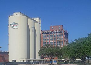
In contrast to greater Houston in general, Fort Bend County's economy is more diverse, with numerous service-sector jobs in healthcare, energy, education, hospitality, and other areas. Major companies with a presence in the county include Schlumberger, Minute Maid, Fluor, and Sunoco's logistics operations in Sugar Land. The Houston Business Journal reported in 2010 that the diversity of industries promoted decades of rapid population growth. After Memorial Hermann Hospital and St. Luke's Episcopal Hospital opened facilities in Fort Bend County, already home to local facilities for Houston Methodist Hospital in Sugar Land, as well as locally based OakBend Medical Center in Richmond, many doctors moved their offices to the county. Compared to Montgomery County, which has experienced rapid growth in corporate employment following ExxonMobil's decision to move its greater Houston operations to an area directly south of The Woodlands, Fort Bend County has yet to experience significant corporate growth, though Schlumberger recently announced plans to move its North American headquarters to Sugar Land.
Healthcare
The county does not have a hospital district. OakBend Medical Center serves as the county's charity hospital which the county contracts with.
Education
Public school districts
School districts in the county include:
- Brazos Independent School District (formerly Wallis-Orchard ISD)
- Fort Bend Independent School District
- Katy Independent School District
- Lamar Consolidated Independent School District
- Needville Independent School District
- Stafford Municipal School District
Kendleton Independent School District, which formerly served parts of the county, closed in 2010 and merged into LCISD.
Higher education
- University of Houston Sugar Land campus
The Texas Legislature assigns these community college districts to the following:
- Houston Community College System: Katy ISD, Stafford MSD, and portions of FBISD in the Houston, Missouri City, and Pearland city limits, and areas not in Wharton County Junior College (in other words, not in Sugar Land, not in Sugar Land's extraterritorial jurisdiction)
- Wharton County Junior College: The City of Sugar Land and its extraterritorial jurisdiction, Lamar CISD (including the former Kendleton ISD), Needville ISD, and Brazos ISD (stated in the legislation as Wallis-Orchard)
Technical school
- Texas State Technical College
Libraries
Fort Bend County Libraries operates many libraries in the county.
Houston Public Library operates one branch in the county, the Stimley Blue Ridge Neighborhood Library in Blue Ridge, Houston.
Media
Local newspapers in the county include three weeklies: the Fort Bend Star, headquartered in Stafford; the Fort Bend Independent; and the Fort Bend Sun, headquartered in Sugar Land. The daily Fort Bend Herald and Texas Coaster focuses on news coverage in the Richmond-Rosenberg area. Fort Bend County is also a major service area for the Houston Chronicle, which provides separate local coverage for the Sugar Land and Katy areas.
Transportation
Major highways
- Interstate 10
- Interstate 69
- U.S. Route 59
U.S. Route 90 Alternate- State Highway 6
- State Highway 36
- State Highway 99 — Grand Parkway (Under Construction)
- Fort Bend Parkway
- Westpark Tollway
Major Farm to Market Roads
- Farm to Market Road 359
- Farm to Market Road 442
- Farm to Market Road 521
- Farm to Market Road 762
- Farm to Market Road 1092
- Farm to Market Road 1093
- Farm to Market Road 1462
- Farm to Market Road 1463
- Farm to Market Road 1464
- Farm to Market Road 1876
- Farm to Market Road 2234
- Farm to Market Road 2759
- Farm to Market Road 2977
- Farm to Market Road 3345
Airports
The sole publicly owned airport in the county is Sugar Land Regional Airport in Sugar Land.
Privately owned airports for public use include:
- Houston Fort Bend Airport in an unincorporated area east of Beasley
- Houston Southwest Airport in Arcola
- Westheimer Air Park in an unincorporated area between Fulshear and Houston
Privately owned for private use:
- Cardiff Brothers Airport in an unincorporated area near Fulshear and Katy
- Dewberry Heliport is a general-aviation heliport (privately owned, for private use) in unincorporated areas between Fulshear and Katy.
The closest airport with regularly scheduled commercial service is Houston's William P. Hobby Airport in Harris County. Fort Bend County is also within the primary service area of George Bush Intercontinental Airport in Houston.
Mass transit
Fort Bend County officially created a department of public transportation in 2005 that provides commuter buses to Uptown, Greenway Plaza, and Texas Medical Center. It also provides demand-and-response buses to senior citizens and the general public that travel only in Fort Bend County. Parts of the county, such as Katy and Missouri City, participate in the Metropolitan Transit Authority of Harris County and are served by several park-and-ride routes.
Freeway system
The TTC-69 component (recommended preferred) of the once-planned Trans-Texas Corridor went through Fort Bend County.
Toll roads
The Fort Bend County Toll Road Authority in Sugar Land manages and operates tolled portions of these toll roads operating in the county:
- Fort Bend Parkway
- Westpark Tollway
- Grand Parkway Toll Road
Notable people
- Brittney Karbowski, American voice actress
- CeeDee Lamb, Wide Receiver for the Dallas Cowboys
See also
In Spanish: Condado de Fort Bend para niños