Juliff, Texas facts for kids
Quick facts for kids
Juliff, Texas
|
|
|---|---|

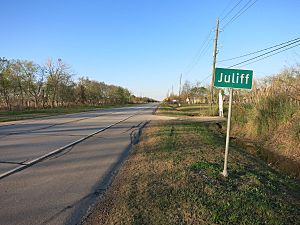
Juliff sign on FM 521 looking north
|
|
| Country | United States |
| State | Texas |
| County | Fort Bend |
| Elevation | 59 ft (18 m) |
| Time zone | UTC-6 (Central (CST)) |
| • Summer (DST) | UTC-5 (CDT) |
| ZIP code |
77583
|
| Area code(s) | 979 |
| GNIS feature ID | 1378507 |
Juliff is a small, unincorporated community located in Fort Bend County, Texas, United States. It is part of the larger Greater Houston metropolitan area. An "unincorporated community" means it's a settlement that doesn't have its own local government. Instead, it is governed by the county.
Contents
History of Juliff
The history of Juliff goes back to the time before the American Civil War. This period is sometimes called the "Antebellum" era. The area where Juliff is located was once part of a large farm called the Arcola Plantation.
How Juliff Got Its Name
The community received its name from an early settler named John J. Juliff. In the 1850s, Juliff was an important shipping point along the Brazos River. This river helped transport goods.
Railways and Post Offices
In 1858, a railway called the Houston Tap and Brazoria Railway opened in the community. This helped Juliff grow. A post office was established in 1891, allowing people to send and receive mail. A general store also opened in 1896. The post office closed for a short time in 1908 but reopened in 1914.
"Diddy Wa Diddy" Era
In 1933, a man named Thurman "Doc" Duke bought land near the railroad. He opened a store and rented out other parts of his land. People who rented from him opened a dance hall and several taverns. The community became known by the nickname "Diddy Wa Diddy," inspired by a popular song.
Population Changes and Modern Times
By 1940, Juliff had about 50 residents, a church, and three businesses. The population grew to 150 people during the 1940s. The post office closed permanently in 1958. By the 1960s, many of the local businesses had closed or moved to Houston.
In 1981, a road called FM 521 took over part of the old State Highway 288, running through Juliff. By 2014, the old railroad tracks had been removed from the area.
Geography of Juliff
Juliff is located on FM 521. This road is between County Road 56 (which is also called Juliff-Manvel Road) and County Road 57 (Fort Bend County Road).
Location Details
The community is about 3.3 miles (5.3 km) south of Arcola. It is also about 7.2 miles (11.6 km) north of Rosharon. In 2008, a signpost on FM 521 (Almeda Road) marked the location of Juliff.
Education in Juliff
Students living in Juliff attend schools that are part of the Fort Bend Independent School District (FBISD).
School Board and Divisions
The community is located within the East Division of the school district. This division controls school board positions 5 through 7.
Zoned Schools
Students from Juliff are currently zoned to attend these schools:
- Heritage Rose Elementary School
- Thornton Middle School
- Almeta Crawford High School
Past School Zones
Over the years, Juliff has been zoned to different schools. Before Hightower High School opened, students attended Elkins High School. For a time, Juliff was zoned to Hightower. It was also served by Ridge Point High School for a period. In the past, students attended Schiff Elementary School and Billy Baines Middle School.
Community College Access
The Texas Legislature has decided that the Houston Community College (HCC) system serves Juliff. This means that residents of Juliff can attend Houston Community College.
 | George Robert Carruthers |
 | Patricia Bath |
 | Jan Ernst Matzeliger |
 | Alexander Miles |


