
Richmond, Texas facts for kids
Quick facts for kids
Richmond, Texas
|
|
|---|---|

St. John's United Methodist Church, a historic landmark.
|
|
| Motto(s):
"A Charming Past. A Soaring Future"
|
|

Location of Richmond, Texas
|
|
| Country | United States |
| State | Texas |
| County | Fort Bend |
| incorporated | 1837 |
| Government | |
| • Type | Commission-manager |
| Area | |
| • Total | 4.44 sq mi (11.50 km2) |
| • Land | 4.09 sq mi (10.58 km2) |
| • Water | 0.35 sq mi (0.92 km2) |
| Elevation | 92 ft (28 m) |
| Population
(2020)
|
|
| • Total | 11,627 |
| • Density | 3,077.56/sq mi (1,188.39/km2) |
| Time zone | UTC-6 (Central (CST)) |
| • Summer (DST) | UTC-5 (CDT) |
| ZIP codes |
77406, 77407, 77469
|
| Area code(s) | 281/346/713/832 |
| FIPS code | 48-61892 |
| GNIS feature ID | 1345187 |
Richmond is a city in Texas, United States. It is a suburb of Houston and the main city of Fort Bend County. Richmond is part of the larger Houston metropolitan area. In 2020, about 11,627 people lived in the city.
Contents
History of Richmond
In 1822, early settlers from Stephen F. Austin's colony traveled up the Brazos River. They stopped near where Richmond is today and built a fort called "Fort Bend." The city was named after Richmond, England.
Richmond was one of the first 19 cities to become an official town in 1837. This happened during the time of the Republic of Texas, which was a country before Texas joined the United States.
Many famous people from Texas history lived in Richmond. These include Jane Herbert Wilkinson Long, Deaf Smith, and Mirabeau Lamar. They are all buried in Richmond. Also buried there is Walter Moses Burton, who was the first Black elected sheriff in the United States.
On August 16, 1889, Richmond was the site of a conflict known as the "Battle of Richmond." This was a fight that ended the Jaybird–Woodpecker War. This war was a disagreement over who would lead Fort Bend County after the American Civil War.
A man named Hilmar Moore was the mayor of Richmond for a very long time. He served from 1949 until he passed away in 2012.
In the past, Richmond was mostly home to government offices and non-profit groups. Most of the private businesses in the area were located in the nearby city of Rosenberg.
Geography and Location
Richmond is located near the center of Fort Bend County. Most of the city is on the southwest side of the Brazos River. A smaller part of the city, called Richmond Landing, is on the northeast side. These two parts are connected by US Highway 90A.
The city of Rosenberg borders Richmond to the southwest. US 90A goes east about 8 miles (13 km) to Sugar Land. It also goes west through Rosenberg about 19 miles (31 km) to East Bernard. Downtown Houston is about 30 miles (48 km) to the northeast.
According to the United States Census Bureau, Richmond covers a total area of about 4.44 square miles (11.5 km²). Of this, about 4.09 square miles (10.6 km²) is land, and 0.35 square miles (0.9 km²) is water.
In 2003, a reporter from the Houston Chronicle said that some old buildings in Richmond had been turned into shops or law offices. She also noted that life in Richmond was becoming similar to a big city. It had stores like Wal-Mart and many fast-food restaurants.
As of 2006, there were several shopping centers along U.S. Route 59 south of town. At that time, the area also had horse ranches and tack stores. Another reporter from the Houston Chronicle described Richmond as a mix of old and new. He said it was "a city of contradiction and transition." It seemed unsure if it wanted to be a busy part of Houston or remain a quiet farm town.
Neighborhoods in Richmond
As of 2003, the wealthiest neighborhood in Richmond was Hillcrest.
Another neighborhood, Winston Terrace, began to have houses built in 1940. More homes were built there after World War II. Most of the houses were built between 1940 and 1965. A reporter described Winston Terrace as a "mid-20th-century America" area. It has large oak trees and colorful brick or wood homes. The neighborhood is named after the family of an important early settler.
"Mud Alley" was a nickname for an area in Richmond known for its older bars in 1985. This area was where most of the African Americans in Richmond lived at that time. "Mud Alley" was also called "Little Boomtown" by some.
Areas Near Richmond
Many new communities have been built near Richmond. These areas are close to the Grand Parkway (SH 99) and the Westpark Tollway. They have Richmond addresses, but they are not officially part of the city of Richmond. This means they do not get city services like water or fire services directly from Richmond. Instead, special local districts provide these services. The Fort Bend County Sheriff's department provides police help.
These communities include Pecan Grove, The Lakes of Bella Terra, Long Meadow Farms, and Harvest Green. Many large stores and restaurants have opened along the Grand Parkway in these areas. This part of Fort Bend County is growing very quickly. It is estimated that over 25,000 homes and 10,000 apartments could be built there. This would mean a population of more than 85,000 people.
Climate in Richmond
Richmond has a warm climate. The summers are hot, and the winters are mild. The city gets a good amount of rain throughout the year.
| Climate data for Richmond, TX | |||||||||||||
|---|---|---|---|---|---|---|---|---|---|---|---|---|---|
| Month | Jan | Feb | Mar | Apr | May | Jun | Jul | Aug | Sep | Oct | Nov | Dec | Year |
| Record high °F (°C) | 84 (29) |
89 (32) |
92 (33) |
95 (35) |
99 (37) |
102 (39) |
105 (41) |
105 (41) |
108 (42) |
98 (37) |
91 (33) |
90 (32) |
108 (42) |
| Mean daily maximum °F (°C) | 65 (18) |
68 (20) |
74 (23) |
81 (27) |
88 (31) |
93 (34) |
95 (35) |
96 (36) |
91 (33) |
84 (29) |
75 (24) |
67 (19) |
81.4 (27.4) |
| Daily mean °F (°C) | 55 (13) |
58 (14) |
64 (18) |
71 (22) |
79 (26) |
84 (29) |
86 (30) |
87 (31) |
81 (27) |
74 (23) |
65 (18) |
56 (13) |
71.7 (22.1) |
| Mean daily minimum °F (°C) | 44 (7) |
48 (9) |
53 (12) |
61 (16) |
69 (21) |
75 (24) |
77 (25) |
77 (25) |
71 (22) |
63 (17) |
54 (12) |
45 (7) |
61.4 (16.3) |
| Record low °F (°C) | 6 (−14) |
9 (−13) |
21 (−6) |
32 (0) |
47 (8) |
56 (13) |
63 (17) |
60 (16) |
47 (8) |
30 (−1) |
22 (−6) |
6 (−14) |
6 (−14) |
| Average rainfall inches (mm) | 3.55 (90) |
3.18 (81) |
3.43 (87) |
3.36 (85) |
4.30 (109) |
5.65 (144) |
3.97 (101) |
4.43 (113) |
5.10 (130) |
5.28 (134) |
4.84 (123) |
3.37 (86) |
50.46 (1,282) |
People and Population
| Historical population | |||
|---|---|---|---|
| Census | Pop. | %± | |
| 1870 | 816 | — | |
| 1880 | 1,156 | 41.7% | |
| 1890 | 993 | −14.1% | |
| 1910 | 1,371 | — | |
| 1920 | 1,273 | −7.1% | |
| 1930 | 1,432 | 12.5% | |
| 1940 | 2,026 | 41.5% | |
| 1950 | 2,030 | 0.2% | |
| 1960 | 3,668 | 80.7% | |
| 1970 | 5,777 | 57.5% | |
| 1980 | 9,692 | 67.8% | |
| 1990 | 9,801 | 1.1% | |
| 2000 | 11,081 | 13.1% | |
| 2010 | 11,679 | 5.4% | |
| 2020 | 11,627 | −0.4% | |
| U.S. Decennial Census | |||
| Race | Number | Percentage |
|---|---|---|
| White (NH) | 2,625 | 22.58% |
| Black or African American (NH) | 1,949 | 16.76% |
| Native American or Alaska Native (NH) | 8 | 0.07% |
| Asian (NH) | 213 | 1.83% |
| Pacific Islander (NH) | 3 | 0.03% |
| Some Other Race (NH) | 27 | 0.23% |
| Mixed/Multi-Racial (NH) | 165 | 1.42% |
| Hispanic or Latino | 6,637 | 57.08% |
| Total | 11,627 |
In 2020, Richmond had 11,627 people living in the city. There were 4,231 households and 2,668 families.
In 2000, the city had 11,081 people. There were 3,413 households. About 39.6% of these households had children under 18. About 53.6% were married couples.
The population was spread out by age. About 31.6% of people were under 18. About 10.1% were 65 years or older. The average age was 30 years old.
Economy and Jobs
The Texas Department of Criminal Justice operates several prison units near Richmond. These include the Jester I Unit, Carol Vance Unit, Jester III Unit, and Wayne Scott Unit. They are located about 4 miles (6 km) east of Richmond in an area not officially part of the city.
Arts, Culture, and Libraries

Richmond is home to the George Memorial Library. This is the main library for Fort Bend County Libraries. It also holds the administrative offices for the library system. The library is located along Farm to Market Road 762. Richmond also has the Fort Bend County Law Library.
The main library moved to its current location in Richmond in 1986. The George Foundation helped pay for the 77,000 square foot (7,200 m²) library building. It was built on 6 acres (2.4 ha) of land. The library was designed to allow for future growth. The library has expanded several times, including in 1995 and 2002. The 2002 expansion added two conference rooms.
Education in Richmond

Students living in Richmond attend schools in the Lamar Consolidated Independent School District.
Elementary schools within Richmond city limits include Jane Long, Pink, and Smith.
Wessendorff Middle School, Lamar Junior High School, and Lamar Consolidated High School serve students from Richmond. These three schools are located in Rosenberg.
Some schools in the Lamar Consolidated Independent School District and the Fort Bend Independent School District have "Richmond, Texas" addresses. However, these schools do not serve students who live within the actual city limits of Richmond. Examples include George Ranch High School and Foster High School.
The local community college for the Lamar Consolidated Independent School District is Wharton County Junior College.
Transportation
Fort Bend County Public Transportation provides local bus service in Richmond.
Images for kids
-
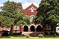
St. John's United Methodist Church, designated as a Recorded Texas Historic Landmark in 1983.
-
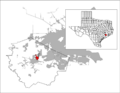
Location of Richmond, Texas
See also
 In Spanish: Richmond (Texas) para niños
