
Long Point, Texas facts for kids
Quick facts for kids
Long Point, Texas
|
|
|---|---|

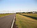
Looking southeast on FM 361 at its intersection with FM 1994
|
|

Long Point, Texas
Location in Texas

Long Point, Texas
Location in the United States
|
|
| Country | United States |
| State | Texas |
| County | Fort Bend |
| Elevation | 75 ft (23 m) |
| Time zone | UTC-6 (Central (CST)) |
| • Summer (DST) | UTC-5 (CDT) |
| ZIP code |
77461
|
| Area code(s) | 979 |
Long Point is a fascinating ghost town located in Fort Bend County, Texas, United States. It's about 24 miles (39 km) southeast of Richmond. You can find it where two roads, Farm to Market Road 1994 (FM 1994) and FM 361, meet. Even though there isn't a sign saying "Long Point," the roads nearby are named after it. Back in the 1930s, people found and took out petroleum (oil) and sulphur from the ground near this area. Today, you can see tall electric towers passing through the site, and there's a county landfill not too far away.
Contents
The Story of Long Point
How Long Point Got Its Name
Local stories say that Long Point got its name from a "point of timber." This was a stretch of trees that stuck out into the wide, open prairie nearby. It was a unique feature that helped people identify the area.
Early Days and Development
By 1936, Long Point was a small community with some important features. It had a road with a metal surface, which was good for travel. A Gulf, Colorado and Santa Fe Railway line also ran through the area, making it easier to transport goods and people. There was even a sulfur mine operating, and a row of homes where people lived.
Mail and Oil Discoveries
Long Point never had its own post office. So, starting in 1947, all the mail for the village was delivered through the nearby town of Needville. An oilfield, known as the Long Point oilfield, was discovered to the east of the community. It started operating in 1936 and was still producing oil in 1987. Even though Long Point appeared on county maps in 1987, we don't know how many people lived there at any point in its history.
Long Point's Location
Roads and Landmarks
While you won't see a sign for Long Point, its name lives on through the roads that meet there. FM 361, which goes northwest from Long Point towards Fairchilds, is also called Fairchilds-Long Point Road. FM 1994 runs from northeast to southwest. To the northeast, it's known as Whaley-Long Point Road, and as it goes southwest towards Guy, it's called Guy-Long Point Road.
Surrounding Features
About half a mile (0.8 km) northeast of where the two farm-to-market roads meet, there's a county landfill that looks like a small hill. You'll also notice large electric transmission towers passing right over the road intersection. These towers carry electricity from the W. A. Parish power plant in Thompsons towards the southwest. An old, unused railway path runs alongside these transmission towers. FM 1994 runs almost parallel to the towers and actually passes directly underneath them at the intersection with FM 361.
Education in the Area
The very first school in Long Point was set up in 1936. Today, Long Point is part of the Needville Independent School District. This means that students from the community attend schools within this district, including Needville High School.
Images for kids
-
View is southeast on FM 361 toward Long Point.
-
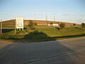
A county landfill is a short distance from Long Point.
-
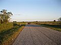
Cattle graze on Davis Estate Road looking southeast.
-
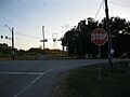
Power lines pass over the intersection of FMs 1994 and 361.


