
Simonton, Texas facts for kids
Quick facts for kids
Simonton, Texas
|
|
|---|---|

Location of Simonton, Texas
|
|
| Country | United States |
| State | Texas |
| County | Fort Bend |
| Area | |
| • Total | 2.37 sq mi (6.14 km2) |
| • Land | 2.35 sq mi (6.09 km2) |
| • Water | 0.02 sq mi (0.05 km2) |
| Elevation | 115 ft (35 m) |
| Population
(2020)
|
|
| • Total | 647 |
| • Density | 376.17/sq mi (145.22/km2) |
| Time zone | UTC-6 (Central (CST)) |
| • Summer (DST) | UTC-5 (CDT) |
| ZIP code |
77476
|
| Area code(s) | 281/346/713/832 |
| FIPS code | 48-67964 |
| GNIS feature ID | 1347151 |
Simonton is a small city in Fort Bend County, Texas, United States. It is part of the larger Houston–Sugar Land–Baytown area. You can find Simonton where Farm roads 1093 and 1489 meet. It's about 14 miles northwest of Richmond. In 2020, 647 people lived here.
Contents
History of Simonton
Early Days: The Simonton Plantation
Simonton's story began in the 1840s. Brothers James and Theophilus Simonton bought 4,000 acres of land. They built a large farm, called a plantation, next to the Brazos River. Here, they grew cotton.
The year 1850 is seen as the start of Simonton. The U.S. Census from that year showed the brothers, their mother, and Theophilus's family living on the land. Another brother, Joseph, joined them later. The Simonton family became important in Fort Bend County. Simonton became one of the main towns in this part of Texas.
Simonton During the American Civil War
By 1860, the Simonton plantation was one of the biggest in Fort Bend County. The family owned many enslaved people. Records show 105 enslaved people worked on their land. The plantation grew a lot of corn and cotton.
Like many Texans, the Simontons supported the Confederacy during the Civil War. They even gave some enslaved people to help the Confederate army. After the war, James Simonton signed an oath to the United States.
After the Civil War: Reconstruction Era
After the war, the plantation land was divided and sold. New settlers bought parts of it. The Simonton family did not like the changes happening during Reconstruction.
They joined a group called the "Jaybirds." This group wanted to remove the "Woodpeckers" from county government. The Woodpeckers were mainly Black people and their white supporters. This conflict was known as the Jaybird–Woodpecker War. It caused a lot of tension in Fort Bend County.
Changes in the Pioneer Era
Over time, the Simonton family's influence lessened. The original brothers passed away. Many immigrants came to Texas through Galveston. They settled in areas like Simonton.
The deaths of the Simonton brothers and the rise of new industries changed the town. Simonton, like other places, saw its economy and social structure shift.
In the early 1900s, the Ku Klux Klan was present in Simonton. This was common in many Texas towns. They were active partly because new immigrants came to work on farms and ranches.
From Busy Town to Quiet Community
A big change for Simonton was the arrival of the San Antonio and Aransas Pass Railroad around 1888. The railroad needed water for its steam trains. Simonton became a key stop for water.
With the railroad came more people and new ways to ship farm products. Simonton grew into a strong farming community.
- Red Potato Farming: In 1906, Dave Mullins started growing red potatoes. Soon, farmers shipped 800 train cars of potatoes from Simonton. It became a major potato producer. Later, new types of potatoes and diseases reduced this demand. Farmers then grew alfalfa, cotton, pecans, and raised cattle.
- Cattle Ranching: The Simonton area became famous for pure-bred cattle. Ranches like Diamond C and Pecan Acres raised special breeds. They were closely linked to the annual Houston Livestock Show.
- Prison Farm: From 1898 to 1909, Simonton had a prison farm. Convicts cleared land for growing ribbon cane. A barn used by these convicts stood near the town's center for many years.
- Busy Downtown: Simonton had a busy downtown. There were three general stores, one with a hotel. Another hotel was known for its good food. The town also had a blacksmith shop, two cotton gins, a lumber yard, a post office, and a railroad depot.
- Education: The first school for white students opened in 1893. In 1925, a new two-story school was built. It was used for dances, elections, and church services during the Great Depression. The school joined the Lamar Consolidated ISD in 1950. A school for Black students was also established.
- H. Berkman & Co. General Store: Hyman "Harry" Berkman opened this store in 1913. It had the post office, a general store, and a butcher shop. Maurice and Flo Berkman ran the store for over 62 years.
As farming and railroad traffic slowed down, people moved away. Many went to Houston for jobs. The train depot closed in 1953. Simonton became a much quieter place.
Then, new developments began. Vernon Evans and A.E. "Snake" Bailey bought land to create Valley Lodge. This was a western-themed community with stables and a rodeo arena. It was one of the first new neighborhoods outside Houston that people could commute from.
International Visit: Deng Xiaoping in 1979
In 1979, Deng Xiaoping, a top leader from China, visited the United States. During his trip, he came to Simonton. He spent an evening at the Roundup Rodeo.
The Roundup Rodeo was a large indoor arena built in 1963. It held rodeos every Saturday night. Deng rode in a stagecoach. A barrel racer gave him a cowboy hat and a duster coat. He put them on for the crowd.
Deng's visit to the Simonton rodeo was a big moment. It helped improve relations between the U.S. and China. The rodeo closed in 1997.
Pictures of Deng in the cowboy hat were in newspapers. They showed a friendly side of the Chinese leader. His hat is now displayed in the National Museum of China.
Simonton Becomes a City
In 1979, Simonton officially became a city. Its population grew to 603 in 1980. By 2010, it had 814 residents. In 2020, the population was 647.
Geography

Simonton is in the northwest part of Fort Bend County. It is about 2 miles east of the Brazos River. Downtown Houston is about 38 miles to the east.
The city has a total area of about 2.37 square miles. Most of Simonton is in the FEMA 100-year floodplain of the Brazos River. This means it is an area that has a 1% chance of flooding in any given year.
Simonton has had several floods from the Brazos River:
- A major flood in 1913.
- In October 1991, 100 homes flooded.
- In December 1995, 125 homes flooded, causing about $2.5 million in damage.
- In May 2016, cows were stranded by floodwaters.
- In August 2017, Hurricane Harvey caused more flooding.
To help with flooding, Simonton bought two large drainage pumps. These pumps help reduce the impact of river floods. A grant from FEMA helped pay for them.
Demographics
| Historical population | |||
|---|---|---|---|
| Census | Pop. | %± | |
| 1980 | 603 | — | |
| 1990 | 717 | 18.9% | |
| 2000 | 718 | 0.1% | |
| 2010 | 814 | 13.4% | |
| 2020 | 647 | −20.5% | |
| U.S. Decennial Census | |||
Demographics tell us about the people who live in a place. This includes their age, race, and how many households there are.
2020 Census Information
| Race | Number | Percentage |
|---|---|---|
| White (NH) | 406 | 62.75% |
| Black or African American (NH) | 32 | 4.95% |
| Native American or Alaska Native (NH) | 1 | 0.15% |
| Asian (NH) | 8 | 1.24% |
| Some Other Race (NH) | 14 | 2.16% |
| Mixed/Multi-Racial (NH) | 33 | 5.1% |
| Hispanic or Latino | 153 | 23.65% |
| Total | 647 |
In 2020, Simonton had 647 people. There were 229 households and 188 families living in the city.
Education
Students in Simonton go to schools in the Lamar Consolidated Independent School District (LCISD).
- Current schools for Simonton students
- Huggins Elementary School (in Fulshear)
- Leaman Junior High School (in Fulshear)
- Fulshear High School (in Fulshear)
- Previous schools for Simonton students
- Foster High School (Richmond area)
- Briscoe Junior High School (Richmond area)
Private schools
- Simonton Christian Academy (in Simonton)
The local community college for LCISD is Wharton County Junior College.
Media
Simonton is one of the towns featured in a 2009 movie called "The Heart of Texas Movie."
Notable person
- Dobie Gray, a famous singer, was from Simonton.
Images for kids
-
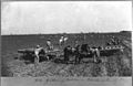
Harvesting potatoes in Fort Bend County, Texas
-

Deng Xiaoping at the start of his visit to the United States in 1979.
-
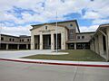
Churchill Fulshear High School
-
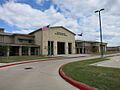
Dean Leaman Junior High School
-
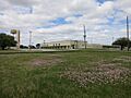
Huggins Elementary School
-
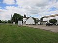
Simonton Community Church on FM 1489 south

.jpg)


See also
 In Spanish: Simonton (Texas) para niños
