
Damon, Texas facts for kids
Quick facts for kids
Damon, Texas
|
|
|---|---|

US Post Office in Damon, Texas
|
|

Location of Damon, Texas.
|
|
 |
|
| Country | United States |
| State | Texas |
| County | Brazoria |
| Area | |
| • Total | 1.4 sq mi (3.6 km2) |
| • Land | 1.4 sq mi (3.6 km2) |
| • Water | 0 sq mi (0.0 km2) |
| Elevation | 79 ft (24 m) |
| Population
(2020)
|
|
| • Total | 436 |
| • Density | 396/sq mi (152.9/km2) |
| Time zone | UTC-6 (Central (CST)) |
| • Summer (DST) | UTC-5 (CDT) |
| ZIP code |
77430
|
| Area code(s) | 979 |
| FIPS code | 48-19108 |
| GNIS feature ID | 1355614 |
Damon is a small community in Brazoria County, Texas, in the United States. It's known as a "census-designated place" (CDP), which means it's a community that isn't officially a city but is recognized for census purposes. In 2020, about 436 people lived there. Damon is located about 20 miles (32 km) south of Rosenberg and sits partly on top of a special underground rock formation called a salt dome. This salt dome has been important for finding oil, sulfur, and limestone in the past.

Contents
Exploring Damon's Location and Land
Damon is found in the northwestern part of Brazoria County. It covers an area of about 1.4 square miles (3.6 square kilometers), and all of it is land.
Rivers and Nearby Towns
The community is located about 2 miles (3 km) from the San Bernard River and 8 miles (13 km) from the Brazos River. Damon is situated between the towns of Needville in Fort Bend County and West Columbia in Brazoria County.
Damon Mound: A Unique Hill
Damon is home to the highest point in Brazoria County, called Damon Mound. This mound rises about 144 feet (44 meters) above sea level. The western part of Damon sits right on top of this mound.
What is Damon Mound?
Damon Mound is actually the top part of a "salt dome." Imagine a huge plug of salt pushing up through layers of rock from deep underground. The top of this salt is about 500 feet (150 meters) below the surface. Above the salt, you can find rocks like limestone, gypsum, and anhydrite.
Oil and Minerals at the Mound
Over time, oil got trapped around the salt dome in layers of sandstone and limestone. A lot of oil has been taken out of this area. For example, by 1924, five million barrels of crude oil were extracted from 85 wells. In 1930 alone, the mound produced 224,000 barrels of oil.
A Look Back: Damon's History
Before Europeans arrived, the Karankawa people lived on Damon Mound. We know this because arrowheads, burial grounds, broken pottery, and stone tools have been found there. Ancient people believed the mound's "sour earth" had healing powers. This was due to natural sulfur and other minerals near the surface.
Early Settlers and Growth
The first European settler, Samuel Damon, arrived from the United States in 1831. He built his home on the south side of the mound. By 1890, the settlement, then called Damon Mound, had about 100 residents. Cattle ranching was a very important business.
Becoming Damon and New Services
In 1895, the post office reopened after being closed for three years, and the town was renamed Damon. A Baptist church was built in 1896. In 1918, a railroad line was built from Rosenberg to Damon. This railroad was used to transport limestone and sulfur, which were dug out from the mound.
Changes Over the Years
By 1925, Damon had 300 residents, and a Catholic church was established. The population dropped to 260 in 1931, but the town still had its own school district. The railroad line was shortened in 1944. Despite this, Damon's population grew to nearly 400 people from the 1940s to the 1980s. In 1989, there were 375 residents, along with businesses like a feed store, a cotton gin, and a quarry. By 2000, the population was 535, and the town had several churches.
Community Services in Damon
Damon has its own volunteer fire department, which helps keep the community safe.
Damon's Population Over Time
| Historical population | |||
|---|---|---|---|
| Census | Pop. | %± | |
| 2000 | 535 | — | |
| 2010 | 552 | 3.2% | |
| 2020 | 436 | −21.0% | |
| U.S. Decennial Census 1850–1900 1910 1920 1930 1940 1950 1960 1970 1980 1990 2000 2010 2020 |
|||
Damon was first officially counted as a "census-designated place" in the 2000 U.S. Census.
Population Details from 2000
In 2000, there were 535 people living in Damon, with 207 households and 149 families. About 30.4% of households had children under 18. Most households (59.4%) were married couples. The average household had 2.58 people.
Population Details from 2010
According to the 2010 census, Damon's total population was 552. There were slightly more males (280) than females (272). About 25.9% of the population was under 18, and 12.9% was 65 or older. The average age was 38.3 years. Most people (83.7%) identified as White, and 31.0% identified as Hispanic.
Damon's "City Limit" Sign
Even though Damon is not an officially incorporated city, it has a "Damon City Limit" sign. You can see it when heading south on State Highway 36 from FM 1462. Usually, only official cities have such signs.
Learning in Damon: Education
Students in Damon are served by the Damon Independent School District. This district provides schooling for students from kindergarten through 8th grade.
High School Education
For high school, Damon students attend Needville High School. This school is part of the Needville Independent School District. Damon ISD and Needville ISD made an agreement in 1949 for Damon students to go to Needville High.
College Opportunities
For students who want to go to community college, Brazosport College is the designated college for residents of the Damon Independent School District.
Images for kids
-
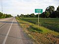
Looking southeast on State Hwy. 36
-
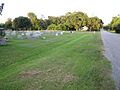
Damon Catholic cemetery
-
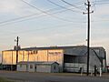
Barta Gin Company on State Hwy. 36
-
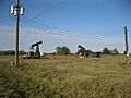
Oil pump jacks along Old Guy Road


See also
 In Spanish: Damon (Texas) para niños
