Snipe, Texas facts for kids
Quick facts for kids
Snipe, Texas
|
|
|---|---|

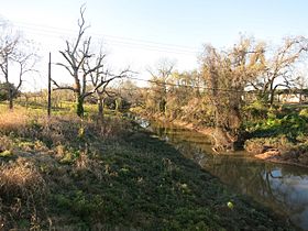
Oyster Creek at the FM 290 bridge
|
|
| Country | United States |
| State | Texas |
| County | Brazoria |
| Elevation | 30 ft (9 m) |
| Time zone | UTC-6 (Central (CST)) |
| • Summer (DST) | UTC-5 (CDT) |
| ZIP codes |
77515
|
| Area code(s) | 979 |
| GNIS feature ID | 1380567 |
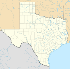
Snipe is a small place in central Brazoria County, Texas. It is an "unincorporated community." This means it does not have its own local government. Snipe is located near the big city area of Greater Houston.
A Look Back at Snipe's History
Snipe got its name in a funny way! Raymond Weems was the first postmaster there. His father's hunting friend made a joke about the place, calling it "Snipe." Raymond liked the name and used it.
Snipe started in an area that used to be a large farm called the Ward Plantation. Around 1905, a railroad called the St. Louis, Brownsville and Mexico Railway built tracks through the community. People living there wanted the train station to be named after an early settler, Ed Matthews. But the station was named Edmonds instead.
A post office served Snipe from 1921 to 1949. This post office also helped the nearby Retrieve Prison Farm. In 1929, there was a railroad bunkhouse and a store for workers. In the early 1930s, Snipe had only one business and about 15 people living there. A big storm in 1932 destroyed the Ward Plantation.
The number of people living in Snipe grew to 75 by 1970. Four years later, it had 78 residents. But by 1988, the community seemed to disappear from records.
Where is Snipe Located?
Snipe is located about 3 miles (5 km) southwest of Angleton. It is found along the Union Pacific Railroad tracks and near a waterway called Oyster Creek.
Learning in Snipe: Education
Today, children living in the Snipe area go to schools in the Angleton Independent School District. Younger students attend Westside Elementary School. Older students go to Angleton Junior High School and Angleton High School. All these schools are located in Angleton.


