Burr, Texas facts for kids
Quick facts for kids
Burr, Texas
|
|
|---|---|

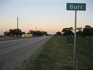
Burr sign
|
|
| Country | United States |
| State | Texas |
| County | Wharton |
| Elevation | 95 ft (29 m) |
| Time zone | UTC-6 (Central (CST)) |
| • Summer (DST) | UTC-5 (CDT) |
| ZIP code |
77488
|
| Area code(s) | 979 |
| GNIS feature ID | 1379484 |
Burr, also known as Lawson's Corner or Kriegel Switch, is a small, unincorporated community in eastern Wharton County, Texas. It's located on Farm to Market Road 1301 (FM 1301), east of the county seat, Wharton. This community began just before the American Civil War when two large farms, called plantations, were started here. In the 1890s, Burr was a busy place, but its population started to decrease by the 1940s. As of 2013, it was still home to a few businesses, homes, and farms.
Contents
History
Early Beginnings (1850s-1880s)
In 1859, Burr Albert Harrison moved his family to this area. He and his workers built a large farm, known as a plantation, along Caney Creek. They also built mills for grinding grain, making sugar, and syrup. Around the same time, another family named Callaway started their own plantation nearby. Records from 1860 show that the Callaways had 90 enslaved people, and the Harrisons had 83.
The community was first called Lawson's Corner. This name came from Dick Lawson, who opened a general store between his plantation and the Harrison farm. Property owners worked together to build a church, but it unfortunately burned down shortly after the Civil War. Burr Harrison passed away in 1881. His son, Gerard Alexander Harrison, took over the plantation. In 1889, he built a large general store that was as good as any in Wharton. This brick building was still standing in 1991.
Growth and Change (1890s-1910s)
A Baptist church was built in Burr in 1892, and another church followed a few years later. In 1896, a German immigrant named Charles Kriegel moved to the area. He bought the Lawson store the next year. A post office was set up in 1899 and was named after Kriegel.
In 1900, the New York, Texas and Mexican Railway (part of the Galveston, Harrisburg and San Antonio Railway) was built. It ran from Wharton to Van Vleck and Sargent. A train station called Kriegel Switch was built in the Kriegel community, across from its school. At that time, Kriegel was roughly halfway between Dinsmore to the west and Burr to the east.
In 1910, the Kriegel post office closed when Kriegel sold his store. Gerard Harrison moved the post office to his own store and renamed it Burr, in honor of his father. By 1915, the Burr community had a church and two stores.
Later Years (1918-Present)
The Burr post office closed in 1918. After that, mail was delivered from Wharton. In 1939, Burr had one business and 83 residents. However, within two years, many people moved away. By 1989, there were only two businesses left in the community.
Geography
Burr is located about 6.6 miles (10.6 km) east of Wharton. It is also about 4.9 miles (7.9 km) northwest of Boling. Caney Creek flows in a very winding path to the south of FM 1301.
Education
A school opened in Lawson sometime after 1889. In 1893, a new school was built in a better location. At that time, most local residents were African-American. The school for white students, known as the Lawson school, had a short school year, lasting only four months.
In 1905, the Lawson school for white students had one teacher and 21 students. Two years later, it had 31 students. In 1907, the Kriegel school had nine teachers and 358 black students. The Lawson school continued to operate in 1915 and was rebuilt in 1919. By 1942, the Lawson school had 100 students. In 1947, it became part of the Boling Independent School District.
 | James Van Der Zee |
 | Alma Thomas |
 | Ellis Wilson |
 | Margaret Taylor-Burroughs |


