
Sargent, Texas facts for kids
Quick facts for kids
Sargent, Texas
|
|
|---|---|

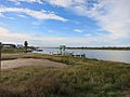
FM 457 swing bridge at the Intracoastal Waterway
|
|
| Country | |
| State | |
| Counties | Matagorda |
| Settled | 1834 |
| Named for | George Thomas Sargent |
| Elevation | 3 ft (0.9 m) |
| Population
(2015)
|
|
| • Total | 2,764 |
| Time zone | UTC-6 (CST) |
| • Summer (DST) | UTC-5 (CDT) |
| ZIP code |
77414
|
| Area code(s) | 979 |
| FIPS code | 48321 |
| GNIS feature ID | 2805811 |
| Farm Roads | |
Sargent is a small town in Matagorda County, Texas, USA. It's a popular spot for fishing, boating, and water sports. Many people visit Sargent on weekends from bigger cities like Houston, Austin, and San Antonio.
Sargent is located on Farm to Market Road 457. It's about five miles northwest of the Gulf of Mexico. It is also twenty-four miles southeast of Bay City. Around 501 people live in Sargent permanently. But on holiday weekends, the population can grow to as many as 5,000 visitors!
Because Sargent is close to the Gulf of Mexico, East Matagorda Bay, the Intracoastal Waterway, and Caney Creek, it's a great place for fishing. Many people who fish for fun or for work live here. Some popular fish and seafood caught here include Red drum (also called Redfish), Spotted Seatrout (or Speckled Trout), Flounder, Blue Crab, and shrimp.
One special thing about Sargent is that many homes are right on the water. Some neighborhoods, like Caney Creek Estates, started in the late 1950s and early 1960s. After Hurricane Carla caused a lot of damage in 1961, new areas like Downey's Caney Creek and Caney Court were built. These new areas often had waterfront lots created by digging canals from Caney Creek and the Intracoastal Waterway.
Many waterfront lots were first sold as places for camping. Sargent still feels like a fishing camp, with many recreational vehicles around. However, most homes now have permanent houses. You'll also see many private wooden piers and docks. People use these to park their boats. Most piers have electric fishing lights, which are great for night fishing. In colder months, Spotted Seatrout are known to feed near these lights as they move inland.
Sargent Beach has faced problems with coastal erosion. In the 1960s, several rows of beach houses were lost to the sea. Efforts have been made to protect this narrow strip of land. It's bordered by the Gulf of Mexico, the Intracoastal Waterway, Mitchell's Cut, and the San Bernard River.
Contents
Sargent's History
Sargent was named for George Thomas Sargent. He and his family moved to Texas from England in 1834. By 1838, they had settled in Matagorda County. George Sargent quickly became a major landowner in the area.
Sadly, George and his daughter-in-law, Sarah Ann, drowned in a hurricane in 1875. They are buried in a small family cemetery in Caney Creek Estates. Local residents still take care of this cemetery. In 1986, the Texas Historical Commission placed a special historical marker there to remember their story.
Exploring Sargent's Geography
Mitchell's Cut: A Key Waterway
Mitchell's Cut is like an extension of Caney Creek. Caney Creek is long enough to be a river and often has slightly salty water, even far inland. The "Pass" leads into the Gulf of Mexico. It's about a quarter-mile past the entrance to East Matagorda Bay.
This "cut" is a favorite spot for families and people who love to fish. Many local boaters park their boats here, anchor, and wade into different fishing spots. Sometimes, a clear blue ocean current flows into the 50-foot-wide pass near the beach. This makes for excellent fishing.
The cut also lets boats travel to the Gulf for offshore fishing and shrimping. It's very important for businesses that sell live bait and shrimp in the community. Mitchell's Cut is the only pass from Freeport to Matagorda. This makes it very important for East Matagorda Bay, Sargent, and the people who live nearby.
The shoreline between Sargent's pass is a strip of land between the Gulf and East Matagorda Bay. It's part of the Matagorda Peninsula. The pass helps drain water from Caney Creek past the Intracoastal Waterway into the Gulf or East Matagorda Bay. This is especially helpful when there's a lot of rain in the areas near Caney Creek. The water depth and sandbars here change throughout the year. A common issue is a sandbar about 100 yards out that can make it hard for bigger shrimp boats to pass during low tide.
Protecting and Developing Sargent
A big effort to protect Sargent Beach was building a granite breakwater (a wall-like structure). The U.S. Army Corps of Engineers designed and installed it in the early 1990s. This structure helps stop coastal erosion. It also protects homes from storm surge if a tropical cyclone (like a hurricane) hits the area.
In 2013, a company called Coastal Technology Corporation and the Conrad Blucher Institute from Texas A&M University-Corpus Christi received grants. These grants, totaling $340,000, came from the Port of Bay City Authority. The money was used to study ways to improve the pass.
In early 2017, construction started on a pier at Sargent Beach. This pier was made with concrete poles and extended into the Gulf. The pier project was first suggested in 2013. It was paid for by a federal program called the Coastal Impact Assistance Program (CIAP). The U.S. Fish and Wildlife Service managed the project.
The pier was planned to be 10 feet wide and about 500 feet long. It was supposed to end with a 140-foot-wide T-shaped head. The pier surface was planned to be about 17.9 feet above the low tide mark. However, on April 13, 2017, it was announced that construction of the Sargent Fishing Pier would stop temporarily due to a lack of money. This meant the pier ended up being much shorter, only about 180 feet long. It barely reached the water at low tide.
Sargent's Population
| Historical population | |||
|---|---|---|---|
| Census | Pop. | %± | |
| U.S. Decennial Census 1850–1900 1910 1920 1930 1940 1950 1960 1970 1980 1990 2000 2010 |
|||
Learning in Sargent
The schools in Sargent are part of the Van Vleck Independent School District. For college, students from Van Vleck ISD can attend Wharton County Junior College.
Images for kids
-
Caney Creek looking downstream at Crab Trap Grill
-
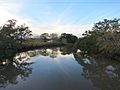
Caney Creek looking upstream at Hawkins Road bridge


