Matagorda Bay facts for kids
Quick facts for kids Matagorda Bay |
|
|---|---|
 |
|
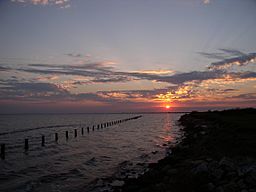
Matagorda Bay at Jensen Point
|
|
| Location | Central Texas Gulf Coast |
| Coordinates | 28°33′56″N 96°12′36″W / 28.56556°N 96.21000°W |
| River sources | Colorado River (Texas), Lavaca River |
| Ocean/sea sources | Gulf of Mexico |
| Basin countries | United States |
| Surface area | 244,490 acres (98,940 ha) |
| Settlements | Port Lavaca, Texas |
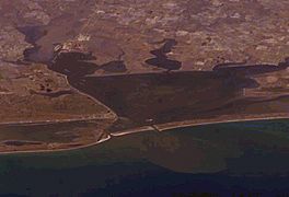
Matagorda Bay is a very large bay on the Texas coast in the United States. It's located about 80 miles (129 km) northeast of Corpus Christi. This bay is one of seven main estuaries along the Texas Gulf Coast. An estuary is where a river meets the sea, mixing fresh and saltwater.
Many streams flow into Matagorda Bay, especially the Lavaca and Colorado Rivers. Important towns like Port Lavaca, Palacios, and Port O'Connor are found along its shores. The bay is separated from the Gulf of Mexico by the Matagorda Peninsula. The land around the bay is rich in wildlife, which helps with tourism like birdwatching and fishing. It's also important for catching seafood like shrimp and blue crab. The fertile land nearby is also great for farming, especially for growing rice.
Contents
History of Matagorda Bay
Early European explorers had different names for this bay, like Espíritu Santo. The first map showing the bay was made by Spanish explorer Alonso Álvarez de Pineda in the late 1510s.
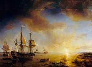
In 1685, French explorer René-Robert Cavelier, Sieur de La Salle tried to start a colony called Fort St. Louis here. He was trying to find the Mississippi River but missed its entrance. Sadly, many colonists died from disease, and others were killed by Karankawa Indians. Only five children survived. This became known as a "lost colony." Spanish explorers later rescued the children from the Karankawa. In 1722, the Spanish built a fort, Presidio La Bahía, and a mission, Mission Nuestra Señora del Espíritu Santo de Zúñiga, at the same spot.
The town of Linnville was founded on Matagorda Bay in 1831. It became a major port for the Republic of Texas. But in 1840, the town was destroyed during the Great Comanche Raid. Its people moved to a nearby place that later became Port Lavaca.
Port Lavaca was founded in 1841 and took over as the main port. However, sandbars in Lavaca Bay made it hard for ships to pass. So, in the 1850s, Indianola became the most important port on Matagorda Bay. Indianola was started in 1846 for German immigrants. It grew quickly and was the second-largest port in Texas by the 1860s, after Galveston.
During the American Civil War, control of Matagorda Bay was very important. The bay changed hands several times between the Union and Confederate forces. The Union forces left the area in June 1864. After the war, Indianola continued to grow. But two strong hurricanes, one in 1875 and another in 1886, caused huge damage. The 1886 hurricane was one of the strongest in U.S. history. Indianola was completely abandoned the next year. Port Lavaca was also hit by the hurricanes but survived and became the largest port on the bay again. It's still the biggest port there today.
Around 1900, East Matagorda Bay was connected to Matagorda Bay. But the Colorado River caused flooding. To fix this, people started a big project in the 1920s to dredge the bay. This didn't stop the flooding, as sediment built up and created new marshland. So, in 1934, the Colorado River was moved to flow directly into the Gulf of Mexico, bypassing Matagorda Bay. This project separated East Matagorda Bay from the main bay. In 1992, the river was sent back into the bay.
Features of Matagorda Bay
The land around Matagorda Bay is part of the Texas Coastal Plain. Near the Colorado River, the area is swampy with lots of wetlands and marshes. You can also find wide coastal prairies with native grasses.
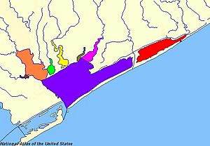
The Matagorda Bay system is usually about 6.5 feet (2 meters) deep. It covers an area of about 422 square miles (1,093 square kilometers). The main parts of the bay include:
- Lavaca Bay, which stretches west to the Lavaca River.
- Tres Palacios Bay, which goes northeast to the Tres Palacios River.
- East Matagorda Bay, which is almost separate from the main bay because of the Colorado River delta.
Other smaller inlets include Turtle Bay, Carancahua Bay, Keller Bay, and Cox Bay.
Matagorda Bay and its connected bays form one of the seven major estuaries along the Texas Gulf Coast. It's the third-largest estuary system in Texas. Water flows into the bay from the Colorado and Lavaca Rivers, plus many smaller creeks. About 150 cubic meters (40,000 gallons) of water flow into the bay every second. Water also moves between the bay and the Gulf of Mexico through places like Pass Cavallo. Because of this mix of fresh and saltwater, the bay's saltiness (salinity) is about 19 parts per thousand. This is less salty than the ocean, which is about 35 parts per thousand.
Ecosystem and Wildlife
Matagorda Bay is home to many different kinds of plants and animals. The Mad Island-Oyster Lake conservation area, on the eastern side of the bay, is a special place for over 300 types of birds. These include songbirds, shorebirds, and waterfowl. This area has seen more bird species than any other place in the U.S. during the National Audubon Society's annual Christmas Bird Count.
Other animals found around the bay include bobcats, white-tailed deer, river otters, Texas horned lizards, and alligators. You can also spot birds like the reddish egret, white-tailed hawk, peregrine falcon, and the piping plover.
Many types of fish live in the bay. Some of the fish caught here include:
- Striped bass
- Gafftopsail catfish
- Atlantic croaker
- Black drum
- Red drum
- Southern flounder
- Spotted seatrout
- Blacktip shark
The bay is also a very important "nursery" for young fish, shrimp, and crabs. This means it's a safe place for them to grow before they move to the open ocean.
Industry and Economy
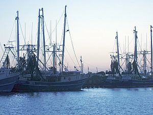
The Matagorda Bay area is famous for fishing because it's an estuary rich in nutrients. The local towns rely on seafood processing, manufacturing, farming, and tourism.
Commercial fishermen catch oysters, blue crabs, and shrimp. Port Lavaca is a top place for processing shrimp in the country. In 1985 alone, over four million tons of seafood passed through its port. Palacios has the largest blue crab processing plant in the United States. It also has the only plant in Texas that quickly freezes shrimp individually.
Recreational fishing is also popular and helps the local economy through tourism. Many visitors enjoy fishing from the Port Lavaca State Fishing Pier. Other fun activities for tourists include hunting, oyster roasts, looking for shells on the beach, and birdwatching.
Several factories are located along the bay, providing jobs for local people. Companies like Aluminum Company of America, Union Carbide, Du Pont, and Formosa Plastics have plants in Point Comfort. The South Texas Nuclear Generating Station is also nearby in Bay City. Oil and natural gas were found in the bay in the 1930s.
The land around the bay is good for farming. Crops like maize (corn), cotton, soybeans, and rice grow well here, especially in the fertile delta area.
See also
 In Spanish: Bahía de Matagorda para niños
 | Leon Lynch |
 | Milton P. Webster |
 | Ferdinand Smith |


