Alonso Álvarez de Pineda facts for kids
Alonso Álvarez de Piñeda (born 1494 – died 1520) was a Spanish conquistador and mapmaker. He was the first person to prove that the Gulf of Mexico was a large bay, not a sea passage to Asia. He did this by sailing all the way around its coast. Alonso was born in Aldeacentenera, Spain. He also created the first map that showed what is now Texas and parts of the Gulf Coast of the United States.
Exploring the Gulf Coast
In 1519, Alonso Álvarez de Piñeda led several trips to map the western coastlines of the Gulf of Mexico. He sailed from the Yucatán Peninsula all the way to the Pánuco River. He also mapped parts of Florida, which many people at that time thought was an island.
Francisco de Garay, who was the Governor of the Colony of Santiago, prepared three ships for Piñeda. These ships had 270 soldiers. Piñeda left Santiago in early 1519. He sailed west to follow the northern coast of the Gulf.
When he reached the western tip of southern Florida, he tried to sail east. But the winds made it too hard. So, he sailed west from the Florida Keys along the Gulf Coast instead.
On June 2, 1519, Álvarez de Piñeda sailed into a large bay. There was a big Native American village on one side of the bay. Many historians think he was describing Mobile Bay and the Alabama River. He also sailed up the Mississippi River for a short distance.
Later in June 1519, around a special day called the Feast of Corpus Christi, Piñeda sailed into a bay he named Corpus Christi Bay. There is no clear proof that he ever stepped onto the land of what is now Texas. However, he did anchor his ships near Veracruz, Veracruz shortly after Hernán Cortés had left.
Cortés returned when he heard that Piñeda had arrived. Piñeda wanted to set a border between the lands he was claiming for Garay and the lands Cortés had already claimed. Cortés did not want to make a deal. So, Piñeda left and sailed back north along his route.
Soon after, he sailed up a river he called Las Palmas. He spent over 40 days there fixing his ships. The Las Palmas River was most likely the Pánuco River. This river is near the city of Tampico in Mexico today.
What He Discovered
Piñeda's journey helped to map the rest of the Gulf of Mexico. It proved that there was no easy sea passage through the Gulf to Asia. His trip also showed that Florida was a peninsula (land surrounded by water on three sides) and not an island.
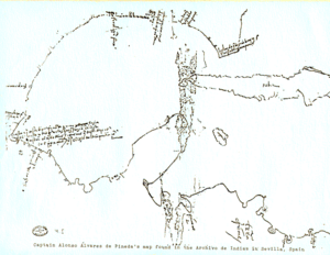
Alonso Álvarez de Piñeda was the first European to see the coastal areas of what is now western Florida, Alabama, Mississippi, Louisiana, and Texas. He called these lands "Amichel". His map is the first known document about the history of Texas. It was also the first map of the entire Gulf Coast of the United States. This important map is kept in Spain at the Archivo General de Indias.
His Death
Alonso Álvarez de Piñeda was killed in a fight with the native Huastec people near the Pánuco River. But his valuable map made it back to Governor Garay.
See also
 In Spanish: Alonso Álvarez de Piñeda para niños
 | Emma Amos |
 | Edward Mitchell Bannister |
 | Larry D. Alexander |
 | Ernie Barnes |


