
Alabama River facts for kids
Quick facts for kids Alabama River |
|
|---|---|

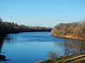
The Alabama River at Montgomery in 2004
|
|

The Mobile, Alabama, and Coosa rivers are essentially a single river the name of which changes at the confluences of major tributaries.
|
|
| Country | United States |
| Physical characteristics | |
| Main source | Tallapoosa and Coosa rivers near Montgomery, Alabama |
| River mouth | Mobile River |
| Length | 318 miles (512 km) |
The Alabama River is a major river in the state of Alabama in the United States. It starts where two other rivers, the Tallapoosa and Coosa rivers, meet. This meeting point is about 6 miles (10 km) north of Montgomery, near a town called Wetumpka.
The river flows west towards Selma. Then, it turns southwest. About 45 miles (72 km) from Mobile, it joins with the Tombigbee River. Together, they form the Mobile and Tensaw rivers, which then flow into Mobile Bay.
Contents
About the Alabama River
The Alabama River takes a very winding path, like a snake. Its width changes quite a bit, from about 50 yards (46 m) to 200 yards (183 m). The depth also varies, from 3 feet (0.9 m) to 40 feet (12 m) deep. The United States Geological Survey says the river is about 318.5 miles (512.6 km) long. If you measure it by how far a steamboat would travel, it's about 420 miles (676 km) long!
The river flows through some of the richest farming and timber areas in Alabama. Railways connect the river to the parts of northern Alabama where minerals are found.
After the Coosa and Tallapoosa rivers, the most important river that flows into the Alabama River is the Cahaba River. The Cahaba is about 194 miles (312 km) long and joins the Alabama River about 10 miles (16 km) downstream from Selma.
The Coosa River, one of the main branches of the Alabama, goes through Alabama's mineral region. Smaller boats can travel on the Coosa from Rome, Georgia, down to about 117 miles (188 km) above Wetumpka. The U.S. government has worked to make the river channel better for boats.
The Tallapoosa River starts in Paulding County, Georgia, and is about 265 miles (426 km) long. However, boats cannot travel on it because of shallow areas (called shoals) and a 60-foot (18 m) waterfall at Tallassee. This waterfall is just a few miles north of where the Tallapoosa joins the Coosa River. The good news is that the Alabama River itself is deep enough for boats all year long!
Historical Importance of the River
In the 1800s, the Alabama River was very important for moving goods and people. It helped the region's economy grow. Today, the river is still used to transport farm products. However, it's not as important as it used to be because we now have many roads and railways.
Europeans first wrote about the Alabama, Coosa, and Tallapoosa rivers in 1701. These rivers were the homeland of the Creek Indians for a very long time. In the 1830s, the Creek people were forced by the United States government to move to a new area called the Indian Territory.
Edmund Pettus Bridge
The Edmund Pettus Bridge crosses the Alabama River near Selma. This bridge is famous because it was the site of important marches for voting rights in 1965. The first of these marches became known as "Bloody Sunday." This was because state and county police attacked and beat the peaceful protesters after they crossed out of the city.
River Locks and Dams
The Alabama River has three special structures called lock and dams between Montgomery and the Mobile River. These structures help boats move up and down the river by changing the water level.
- The Robert F. Henry Lock & Dam is located at river mile 236.2.
- The Millers Ferry Lock & Dam is located at river mile 133.0.
- The Claiborne Lock & Dam is located at river mile 72.5.
Gallery
-
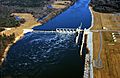
Claiborne Lock and Dam on the Alabama River, about 5 miles (8 km) upriver from Claiborne, Monroe County
-
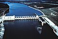
Robert F. Henry Lock and Dam on the Alabama River, about 15 miles (24 km) east of Selma
-
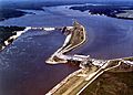
Millers Ferry Lock and Dam on the Alabama River in Wilcox County, about 9.5 miles (15.3 km) northwest of Camden
-
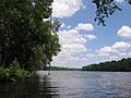
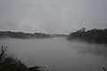
The Alabama River in Dallas County looking upstream towards Selma.
-
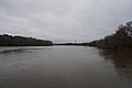
The Alabama River in Lowndes County as seen from Benton Park in Benton, Alabama.
-
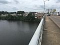
The Edmund Pettus Bridge in Selma overlooking the Alabama River.
-
The Alabama River in Selma
-
Alabama River at Riverfront Park in Montgomery


.jpg)
.jpg)
See also
 In Spanish: Río Alabama para niños
