Cahaba River facts for kids
Quick facts for kids Cahaba River |
|
|---|---|
| Country | United States |
| State | Alabama |
| Physical characteristics | |
| Main source | Jefferson County, Alabama 33°41′15″N 86°36′0″W / 33.68750°N 86.60000°W |
| River mouth | Alabama River Dallas County, Alabama 32°19′9″N 87°05′41″W / 32.31917°N 87.09472°W |
| Length | 194 mi (312 km) |
| Basin features | |
| Basin size | 1,870 sq mi (4,800 km2) |
| Tributaries |
|
The Cahaba River is the longest river in Alabama that flows mostly freely, without many dams. It is one of the most beautiful and diverse rivers in the United States. The Cahaba River is a big branch of the Alabama River and is part of the larger Mobile River system.
The river starts near Birmingham. It flows southwest, then turns southeast at Heiberger. Finally, it joins the Alabama River at the old town of Cahaba in Dallas County. The Cahaba River is entirely within central Alabama. It is about 194 miles (312 km) long and drains an area of 1,870 square miles (4,800 km2).
Contents
River's Journey and Land Types
The Cahaba River flows through three main types of land areas in Alabama. These are the Appalachian Plateau, the Ridge and Valley region, and the Coastal Plain. The Mobile River system, which the Cahaba is part of, has the largest drainage area on the Gulf Coast east of the Mississippi River. The Cahaba is one of seven river systems that feed into it. The area around the river is mostly eastern deciduous forest, which means it has trees that lose their leaves in the fall.
Where the River Flows
The Cahaba River starts in the Valley and Ridge region. This area is bordered by the Piedmont to the southeast and the Cumberland Plateau to the northwest. The river has two main parts: the Upper Cahaba and the Lower Cahaba. It eventually flows into the Alabama River.
The Upper Cahaba covers about the first 100 miles (160 km) of the river. It starts at the very beginning of the river and continues to the Fall Line. The Fall Line is a special area where the Appalachian Mountains end and the Gulf Coastal Plain begins. The river passes through several towns in this upper section. These include Trussville, Leeds, Irondale, Birmingham, Mountain Brook, Hoover, Vestavia, Helena, West Blocton, and Centreville.
The Lower Cahaba begins at the Fall Line. It flows through Selma and then empties into the Alabama River at the historic town of Cahaba.
River History
The Cahaba River basin has a rich history, with evidence of people living there for thousands of years.
Ancient Settlements
Near the Cahaba River basin is the Moundville Archaeological Site. This was a very large community of the Mississippian culture that existed from 1000 to 1450 AD. It was the second-largest community of its kind. The Black Warrior River and the Cahaba River flow side-by-side for over 100 miles (160 km), sometimes as close as 30 miles (48 km) apart.
Another important ancient site is the Bottle Creek Site. This site, active from 1250 to 1550 AD, is located further downriver in the Mobile–Tensaw River Delta. It also had an impact on the region. A large mound, which is a type of ancient earthwork, can still be seen on the river just south of Centreville. The area where the town of Cahaba later stood was home to a large village from 100 to 1550 AD, during the Woodland and Mississippian periods.
The Town of Cahaba
The Cahaba River ends at the former town of Cahaba, also known as Cahawba. Early settlers were drawn to this area because the land was perfect for growing cotton. At first, settlement was slow because there weren't many trees and the water lacked lime. But once people realized how rich the land was for cotton, there was a rush to settle in the Black Belt area.
The town of Cahaba was Alabama's first capital city from 1820 to 1825. The town became busy with visitors, ferries, hotels, state buildings, and stores. It even had its own newspaper, the Cahaba Press. William Wyatt Bibb, Alabama's first governor, chose Cahaba because of its beautiful scenery, fertile land, and navigable rivers. The plan was for Cahaba to be the capital only until 1825, when a more permanent location could be chosen.
From 1819 to 1822, Cahaba faced tough economic times and health problems. However, in 1821, a steamboat named the Harriet managed to travel up the Alabama River past Cahaba. This made the river a major trade route, and the city grew. Even after the capital moved to Tuscaloosa in 1825, Cahaba continued to be important. It also served as the main town for Dallas County. After the American Civil War, the county seat moved to Selma.
With the economy collapsing, floods, and diseases, people started to leave Cahaba. It became a community for freed slaves, and later a place for hunting and fishing camps. Today, Cahaba is an abandoned town and a state historical site. The Alabama Historical Commission manages it.
River's Geology
The Ridge and Valley region of Alabama, where the Cahaba River begins, was formed a very long time ago. This happened when the African Plate crashed into the North American Plate during the Paleozoic era. The soils in the valleys are made of gravel, sand, and clay. The ridges are made of chert (a hard rock) and sandstone. The upper Cahaba region has gravel, clay, and sand from the Cenozoic era. In the lower Cahaba region, the soils are calcareous, which means they are chalky.
Amazing River Life

The waters of the Cahaba River are home to an incredible variety of life. More than 131 types of freshwater fish live here, and 18 of them are found nowhere else in the world! The river also has 40 kinds of mussels and 35 kinds of snails. In fact, the Cahaba has more fish species than all the bodies of water in California combined. Sadly, 69 of these animal species are endangered.
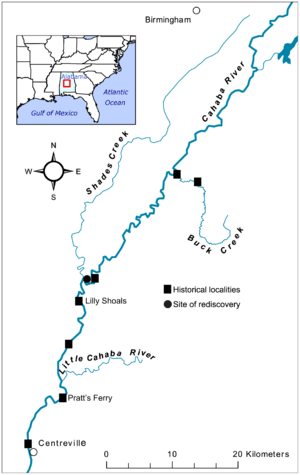
One freshwater snail, Elimia cahawbensis, is named after the river because it is only found there. Another snail, Leptoxis compacta (the Oblong rocksnail), was thought to be extinct but was found again in the Cahaba in 2011.
Over time, the river has lost some species due to dams, pollution, and erosion. Almost a quarter of the original mussel species have disappeared, and fish and snail numbers have also decreased. However, many new species are still being found in and around the river. The Cahaba is also home to 13 snail species that are found nowhere else on Earth.
In the early 2000s, a botanist (plant expert) named Jim Allison discovered eight new flower species along the river. Later, eight more were identified that had never been seen in Alabama before. This region is especially famous for its many types of mollusks and snails. These creatures are important because they feed other aquatic animals, help clean the water by eating algae, and can even show if there are pollution problems because they are sensitive to changes. There are also 14 types of fish in the Cahaba River that are not native to the area.
The Beautiful Cahaba Lily
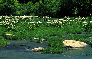
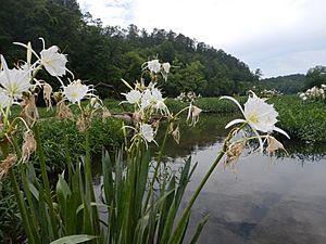
Among the many plants that grow in and around the Cahaba is the Hymenocallis coronaria, known in Alabama as the Cahaba lily. Because there are so many of these lilies here, and because they are threatened in the three states where they grow, a part of the Cahaba River near West Blocton has been made into the Cahaba River National Wildlife Refuge.
These special flowers are found only in South Carolina, Georgia, and Alabama. While they once grew all over the Southeast, they now exist in about 70 groups, and a quarter of these groups are in the Cahaba River. The lily seeds travel with the river's flow. Small cracks in the shoals (rocky areas across the river) protect the seeds as they start to grow.
The Cahaba lilies bloom in early May, and the blooming season ends by mid-June. The flowers open in the evening instead of during the day. This is because they are pollinated by sphinx moths, which are active at night. Each flower blooms and lasts for only one day before it wilts.
Smaller Rivers Joining the Cahaba
Many smaller rivers and streams flow into the Cahaba River. Some of these include:
- Buck Creek, located northwest of Helena.
- Little Cahaba River (of Shelby County), which joins from the southeast near Cahaba Heights.
- Little Cahaba River (of Bibb County), which joins from the east, a few miles north of Centreville.
- Shades Creek, which flows from the northwest after running next to the Cahaba for some distance.
How People Use the River
The Cahaba River flows through busy areas, including the Birmingham metropolitan area. It provides drinking water for over 1 million people in its upper parts. The river is also a popular place for canoeing and other water activities.
Cities Along the Cahaba
Several cities in Alabama are located on the banks of or very close to the Cahaba River. These include:
- Birmingham – where the Cahaba begins.
- Hoover – the Cahaba flows southwest here.
- Helena – the Cahaba flows southwest here.
- Centreville – the Cahaba flows southwest here.
- Heiberger – the Cahaba makes a sharp turn to the southeast here.
- Marion – the Cahaba flows southeast (east of Marion).
- Selma – the Cahaba flows southeast (west of Selma).
- Cahaba – where the Cahaba joins the Alabama River. This was Alabama's first permanent state capital and is now a historic site.
Protecting the Cahaba River
Many groups work to protect and care for the Cahaba River. They help keep the water clean and the river healthy for all its plants and animals.
- The Cahaba Riverkeeper checks the river weekly for safety for swimming and posts the results online. Their goal is to protect the river's natural health and ensure clean water for everyone to enjoy. They also look for any activities that might break clean water laws.
- The Cahaba River Society is Alabama's biggest group focused on river conservation. They are known across the country for their work. They use a balanced, science-based approach to restore and protect the Cahaba River and its amazing variety of life.
- The Nature Conservancy Sustainable Waters Program works with different groups to solve water issues related to farms, energy, cities, and floodplains.
- The Cahaba River Basin Clean Water Partnership aims to find problems, explore solutions, and make suggestions for managing the Cahaba River basin. They try to balance protecting the environment with helping the economy.
- The Alabama Rivers Alliance works to bring people together in Alabama to protect their right to clean, healthy water.
- Alabama Water Watch helps volunteers monitor the water quality in Alabama's rivers.
- The Presbytery of Sheppards and Lapsley, a church group, is building a camp and conference center called Living River on the Cahaba River. They are working hard to develop this center in a way that protects the environment. They also helped remove the Marvel Slab Dam, which allowed a large part of the river to flow freely again.
- The Freshwater Land Trust is a non-profit group that buys and cares for land to improve water quality and protect open spaces in Central Alabama.
 | Emma Amos |
 | Edward Mitchell Bannister |
 | Larry D. Alexander |
 | Ernie Barnes |


