
Gulf Coastal Plain facts for kids

The Gulf Coastal Plain is a large, flat area of land. It stretches around the Gulf of Mexico in the Southern United States and eastern Mexico. This plain is like a wide belt of low-lying land.
In the United States, it covers parts of Florida, Georgia, Alabama, Mississippi, Tennessee, Kentucky, Illinois, Missouri, Arkansas, Louisiana, Oklahoma, and Texas. In Mexico, it continues along the Gulf through Tamaulipas, Veracruz, Tabasco, and the Yucatán Peninsula.
Contents
Geography of the Plain
The Gulf Coastal Plain touches the Gulf of Mexico in the south. In Mexico, it reaches the Sierra Madre de Chiapas mountains. To the north, it extends to the Ouachita Highlands and the southern Appalachian Mountains. Its northernmost point is in southern Illinois, along the Mississippi embayment. To the east, it connects with the South Atlantic Coastal Plain in Georgia. This happens where rivers flow either to the Gulf or the Atlantic.
The land here is mostly flat or gently rolling. It has many streams, rivers, and wetlands like marshes.
United States Section
The Gulf Coastal Plain is a western part of the Atlantic Coastal Plain. It wraps around the Gulf of Mexico. The areas closest to the sea are very flat. But further inland, the land becomes more hilly with valleys. This is because rivers have cut through the land over time.
Some special features of the Gulf Plain include:
- The peninsula of Florida that sticks out into the sea.
- Different types of land and soil arranged in "belts" in Alabama and Texas.
- The Mississippi embayment, which is an inland extension of the plain. It goes halfway up the Mississippi River to where it meets the Ohio River in Cairo, Illinois.
Florida Peninsula
Florida's lowland peninsula is a wide, low arch of land. The northern part of Florida is made mostly of a soft limestone. Because of this, much of the water drains underground. This creates many sinkholes, which are holes in the ground that form when limestone dissolves. Many small lakes in Florida also formed this way.
The southern part of Florida includes the Everglades. This is a huge area of low, flat, marshy land covered with tall grass. The eastern coast has long sand reefs. These reefs create narrow, long lagoons behind them. At the southern tip of Florida are the Florida Keys. These are a chain of coral islands. They grew from corals and other sea creatures.
Alabama and Mississippi Belted Plain
A good example of a "belted" coastal plain is in Alabama and nearby Mississippi. Here, the plain is about 150 miles (240 km) wide. The lowest layer of rock is mainly soft limestone. This limestone has worn away in some areas. It formed a flat, inner lowland with rich black soil. This area is called the "black belt."
This lowland is surrounded by a higher area or escarpment. This escarpment is called Chunnenugga Ridge. It is made of sandier layers of rock. The escarpment slopes steeply down to the inner lowland. It then slopes very gently towards the coast. Near the Gulf, the land becomes very low, flat, and marshy. It is often bordered by sand reefs offshore.
Mississippi Embayment
The coastal plain stretches 500 miles (800 km) inland along the Mississippi embayment. This is where the plain extends far into the continent. It crosses over older landforms like the Appalachian Mountains and the Ozark plateau. These older landforms gently dip down and are covered by the coastal plain's layers of rock.
The Ozark plateau in southern Missouri and northern Arkansas is similar to the Appalachian plateau. The Ozarks and Ouachita Mountains are the only major mountain regions between the Rocky Mountains and the Appalachians. As the coastal plain turns west towards Texas, it borders the Ouachita Mountains and the Arbuckle Mountains in Oklahoma.
Mississippi River Basin
In the Mississippi embayment, there are some low, hilly areas. These areas have features like a belted coastal plain. The most noticeable is a hilly belt in western Mississippi. Important salt deposits are found near the coast in the plain's rock layers.
The most striking feature of this area is the wide valley that the Mississippi River has carved. The Missouri River joins the Mississippi River, greatly increasing its flow. The lower Mississippi River does not have many large rivers joining it from the east. But it has two important ones from the west: the Arkansas River and the Red River of Louisiana. The Mississippi River drains about one-third of the United States.

The Mississippi River flows south for about 560 miles (900 km) through the plain. It has carved a valley about 40 to 50 miles (64 to 80 km) wide. This valley is enclosed by bluffs that are 100 to 200 feet (30 to 60 m) high in the north. These bluffs get lower towards the south.
The floor of this valley is covered with a floodplain of fine silt. This floodplain slopes gently southward. The river itself is about 1,060 miles (1,710 km) long from the Ohio River to the Gulf, due to its many curves. The river carries a lot of silt from its tributaries. It also picks up and drops silt from its own bed and banks.
The river often forms large curves called meanders. These meanders tend to make the river longer. But sometimes, the river cuts across a meander, making it shorter again. This helps keep the river's length fairly constant.
Mississippi River floods usually happen in spring or summer. Because the river basin is so large, it's rare for all its main branches to flood at the same time. But if two large branches flood together, the lower river can rise 30, 40, or even 50 feet (9 to 15 m).
The silt carried by the river eventually reaches the Gulf of Mexico. Here, the river slows down. The salty sea water also helps the silt settle. This forms a remarkable delta. The Mississippi delta is not the usual triangular shape. This is because the river's current is very strong. It divides into four main channels or "passes" near its mouth.
Coastal Plain in Louisiana and Texas
The coastal plain narrows to about 250 miles (400 km) in western Louisiana. It then continues southwest into Texas. In southern Texas, near the Colorado River, it narrows to about 130 miles (210 km). But it widens again to 300 miles (480 km) at the border with Mexico. This is partly because of the Rio Grande valley and its delta.
This area covers over 100,000 square miles (260,000 km²). It has a "belted" arrangement of landforms and soils. This is due to different types of rock wearing away at different rates. Most of the plain is treeless prairie. But the sandier belts have forests. Two of these are called "cross timbers." This is because they run across the general direction of the main rivers.
An inland part of the coastal plain in north-central Texas leads to a large escarpment called Grand Prairie. This escarpment is held up by strong limestone. It slopes gently towards the sea. Many branching streams cut through it.
As the plain approaches the Colorado River in its southern part, the Grand Prairie escarpment breaks into a belt of hills. The western cross timbers follow a sandy belt at the base of the Grand Prairie. The eastern cross timbers follow another sandy belt. This is in the lowland between the Grand Prairie and the Black Prairie escarpment.
The Black Prairie escarpment is supported by a chalk formation. It has a gentle, rolling slope towards the sea. This area has rich black soil and is an important cotton-growing region. Then comes the East Texas timber belt. This is a low, hilly escarpment of sandy rock. Finally, there is the Coast Prairie. This is a very young plain with a very gentle slope towards the sea. Its smooth surface is only broken by the flat floodplains of the rivers.
Near the Colorado River, the Grand Prairie escarpment changes into the Edwards plateau. This plateau ends in a large fault scarp. This scarp is about 300 or 400 feet (90 or 120 m) high. It forms the northern boundary of the Rio Grande embayment. From the Colorado River to the Rio Grande, the Black Prairie, timber belt, and Coast Prairie blend into a vast plain. This plain is covered with chaparral, which are shrub-like, often thorny trees. It widens eastward into the Rio Grande delta and extends south into Mexico.
The Coast Prairie is a very new landform that was once under the sea. Its small rivers flow into bays. However, larger rivers like the Mississippi and Rio Grande have built large deltas. These deltas push the land forward into the sea. The Mississippi River is rapidly building its finger-shaped delta. The Rio Grande has built its delta about 50 miles (80 km) forward from the general coastline.
Most of the coast is fringed by long sand reefs or barrier islands. These are built by waves from the very shallow sea bottom. Because the tides are weak, these barrier islands stretch for long distances without breaks.
Habitats
The northern uplands of the Gulf Coastal Plain are mostly covered by pine trees. Originally, these were longleaf and slash pines in the south. In the north, shortleaf pines mixed with hardwood trees. These forests are managed by natural processes like fire. In wetter areas, you find bald cypress and hardwoods. Large lowland areas have bottomland hardwood forests.
The southern part of the region has tropical and subtropical moist broadleaf forests. It also has western Gulf coastal grasslands. These areas include large habitats of freshwater wetlands, salt marshes, and coastal mangrove swamps. Many water birds spend the winter in the lower parts of the Gulf Coastal Plain.
Groundwater
Scientists have studied groundwater resources using satellites. They found that groundwater is shrinking because too much is being used. This causes worries about water safety as the climate changes. The quality of surface water is also getting worse. This is due to more people, less water in streams, and land sinking along some coastlines.
The Atlantic and Gulf Coastal Plain Aquifer has low to moderate stress. However, the region's economy and how land is used show that humans are putting more and more stress on water resources.
Images for kids
-
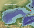
The Gulf of Mexico and Coastal Plain
-
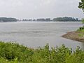
The Missouri River (center) joins with the Upper Mississippi River (right), more than doubling the flow south (left). Wood River, Illinois is in the foreground.
See also
 In Spanish: Llanura costera del Golfo para niños
